SPECIAL ANNOUNCEMENT |
 |
We're going to keep it simple today. A SPECIAL AVALANCHE ADVISORY is in effect for the mountains of northern Utah. In terrain above about 8000 feet that faces west through north through southeast, natural avalanches are possible and human triggered avalanches are almost certain on numerous slopes.
Beaver Mountain opens tomorrow (Monday), and you can get discount lift tickets (here). All proceeds from sales will support the Utah Avalanche Center through the Friends of the Utah Avalanche Center...... |
|
|
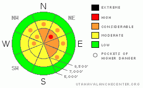
BOTTOM LINE
Danger by aspect and elevation on slopes approaching 35° or steeper.
(click HERE for tomorrow's danger rating)
|
Danger Rose Tutorial
|
There’s a CONSIDERABLE danger in the backcountry today and dangerous avalanche conditions exist on steep slopes with recent and older deposits of wind-drifted snow. Avalanches on some slopes may step down into old buried weak layers.
Avoid steep slopes and obvious or historic avalanche paths and use conservative decision making, careful route finding, and good travel habits. Training and experience are essential in the backcountry today.
|
|
|
CURRENT CONDITIONS |

|
Expect another cloudy and snowy day in the mountains. Mountain temperatures climbed a bit overnight and will continue to warm up into the twenties this morning at 8000'. Showery snowfall should continue at higher elevations and a couple inches of accumulation is not out of the question...
The mountains around Logan picked up over three-and-a-half inches of water equivalent in the past week, much of this in the form of light powder. The Tony Grove Snotel picked up a few inches of snow with another half inch of water during the day yesterday, which brings the 48 hr water equivent gain to 1.1" There's a bit over 40" of total snow on the ground at 8400'
Overnight westerly winds at the Campbell Scientific weather station on Logan Peak averaged less than 15mph, with gusts in the 20s, and it's now a balmy 6 degrees at 9400'.
The Tony Grove Road is not maintained for wheeled vehicles this time of year, and you should not try to drive up it without a shovel...Word is, that Beaver plans to open on Monday. Ted doesn't mind a little help packing down the slopes, but the unopened area should still be treated as backcountry. A hike on the familiar runs of the Beav might offer you a safer and more easily accessable option this weekend. Riding conditions have improved drastically with last week's snow. But, due to the danger of tagging a shallowly buried rock and uncertain avalanche conditions, most people I've talked to are sticking to the deep powder in the low angle meadows and avoiding the bigger, steeper hills..... |
|
|
RECENT ACTIVITY |

|
Significant natural and human triggered avalanches continue to plague the Central and Southern Wasatch Range and the list of recent backcountry avalanches in the Salt Lake and Park City areas is staggering. (see Wasatch avalanche list). Snow safety personnel up at one of the Ogden Area resorts yesterday triggered a large avalanche with explosives on a northeast facing slope at 9000', which broke into facets near the ground below the stout mid-November rain-crust.
On Friday, we were able to trigger a couple small soft slabs on a test slope. These were around a foot deep, failing on weak surface snow formed earlier in the week. Last weekend, skiers triggered a couple avalanches in the Logan Area Backcountry, (photos), but I've not observed any, and no avalanches were reported locally since then...
It's only a matter of time (and weight) before we start seeing dangerous and large avalanches breaking into old snow in some areas.....Buried weak layers are present and a slab is building up on top of them. It's difficult to tell exactly when a slope will reach the critical balance that will allow you to trigger it. |
|
|
THREAT #1 |

|
| WHERE |
PROBABILITY |
SIZE |
TREND |

|
|
|
|
| |
|
|
Over the next
24 hours.
|
|
|
It's only a matter of time (and weight) before we start seeing dangerous and large avalanches breaking into old snow in some areas.....
Strong pre-frontal southwest winds on Friday built tricky wind-slabs in exposed terrain, mainly on north and east facing slopes. Some of these now sit atop a weak layer consisting of surface hoar or frost crystals formed during Tuesday and Wednesday nights under clear cold weather conditions. These wind slabs, (technically now persistent slabs) are now buried by yesterday's nice light powder.
Friday's snow and strong winds overloaded both buried and surface weak layers. I noted a weak snowpack structure at mid-elevations this week, and the mid-November rain-crust, which is currently "bridging" the building slab over extremely weak faceted snow, appears to be deteriorating somewhat, especially in areas with shallow snow cover. Hard to predict exactly when, but avalanches on some slopes may break into older snow layers with the recent additional load . |
|
|
THREAT #2 |

|
| WHERE |
PROBABILITY |
SIZE |
TREND |

|
|
|
|
| |
|
|
Over the next
12 hours.
|
|
|
Watch for and avoid areas with fresh drifts of smooth, stiffer, wind deposited snow especially in and around terrain features like gullies, cliff bands or roll-offs. |
|
|
MOUNTAIN WEATHER |

|
A chilly, moist weather pattern will continue today and a few inches of snow are expected in our area. Mountain temperatures will rise significantly and we can expect high temperatures up near 20 degrees at 9000'. The next strong Pacific storm, tracking in from the northwest, looks like it will produce significant snowfall for the region, with two feet or more accumulation possible Sunday night and Monday. Looks like the productive pattern will continue through most of the rest of the month.... |
|
|
GENERAL ANNOUNCEMENTS |
The major access to upper elevation snow is via the Tony Grove Road, which is not maintained for wheeled vehicles in the winter. It is however, heavily used by different wintertime user groups, and this time of year patience and restrained speeds in congested areas are important safety concerns....
If you have observations from the backcountry, especially if you see or trigger an avalanche, please let us know. You can leave a message at (435) 755-3638 or 1-800-662-4140, or email us at uac@utahavalanchecenter.org. (Fax 801-524-6301).
The UAC depends on contributions from users like you to support our work. To find out more about how you can support our efforts to continue providing the avalanche forecasting and education that you expect please visit our Friends page.
The information in this advisory is from the U.S.D.A. Forest Service, which is solely responsible for its content. This advisory describes general avalanche conditions and local variations always occur. |
|
|
This information does not apply to developed ski areas or highways where avalanche control is normally done. This advisory is from the U.S.D.A. Forest Service, which is solely responsible for its content. This advisory describes general avalanche conditions and local variations always occur. |
|
This advisory provided by the USDA Forest Service, in partnership with:
The Friends of the Utah Avalanche Center, Utah Division of State Parks and Recreation, Utah Division of Emergency Management, Salt Lake County, Salt Lake Unified Fire Authority and the friends of the La Sal Avalanche Center. See our Sponsors Page for a complete list. |
