SPECIAL ANNOUNCEMENT |
 |
Please consider an end of the year donationto your favorite non-profit –The Friends of the Utah Avalanche Center. The Utah Avalanche Center depends on contributions from users like you to support our work..... |
|
|
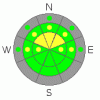
BOTTOM LINE
Danger by aspect and elevation on slopes approaching 35° or steeper.
(click HERE for tomorrow's danger rating)
|

Danger Rose Tutorial
|
You'll find heightened avalanche conditions and a level 2 or Moderate danger in steep backcountry terrain. You could trigger stiff wind slab avalanches running on shallowly buried persistent weak layers on some steep drifted slopes. Also on very steep slopes, you are still likely to trigger loose dry sluffs, which could entrain significant volumes of snow and be potentially long running. In both cases, the greatest danger may come from being swept into shallowly buried rocks or trees below. You should continue to evaluate the snow and terrain carefully in steep upper and mid-elevation terrain.... |
|
|
CURRENT CONDITIONS |

|
A spike in westerly windspeeds overnight heralded a change in the weather pattern. Even a little snow will help out the shallow conditions in the backcountry, and we might see a little this week.The CSI Logan Peak weather station at 9700' reports overnight westerly winds averaging around 30 mph for several hours and a current temperature of 14 degrees. The Tony Grove Snotel at 8400' reports 26 degrees, and there is 31 inches of total snow on the ground. With 7.4 inches of water equivalent, the station sits at 59% of average for the date. Riding conditions are still quite boney, with many riders reporting significant sled damage from off track ventures. |
|
|
RECENT ACTIVITY |

|
No avalanches have been reported recently in the Logan Zone.... A couple ski areas in the Central Wasatch Range reported sluffs that gouged deeply into sugary or faceted snow and entrained a significant volume. |
|
|
THREAT #1 |

|
| WHERE |
PROBABILITY |
SIZE |
TREND |

|
|
|
|
| |
|
|
Over the next
12 hours.
|
|
|
Overnight west winds picked it up a notch, and despite somewhat limited available snow to transport, probably built wind slabs in some exposed terrain. Also, some 4-day-old stiffer wind slabs may be balanced on weak sugary facets or feathery surface hoar. Wind slab avalanches could be up to around a foot deep and you might trigger them remotely, from a distance or below.. Watch for stiffer, wind drifted fresh snow on the lee sides of ridges and subridges and in and around terrain features like gullies, scoops, and cliff bands... Even a fairly small avalanche could be quite dangerous if you are caught and carried over shallowly buried rocks or into trees below.... |
|
|
THREAT #2 |

|
| WHERE |
PROBABILITY |
SIZE |
TREND |
|
|
|
|
| |
|
|
Over the next
24 hours.
|
|
|
Triggered loose dry sluffs entraininug significant volumes of weak sugary snow are again probable on very steep slopes with unconsolidated snow, so avoid terrain where you could be swept into gullies, rocks or trees below.. Be sure you are not above or below your partners or other parties, and be sure to watch above as you descend. |
|
|
MOUNTAIN WEATHER |

|
An increasingly moist zonal or westerly flow will develop over our area. A series of fast moving but weak disturbances should break up the inversion and bring some light accumulating snow to the mountains around midweek.Expect mostly sunny and breezy conditions today, with increasing clouds. Clouds will thicken overnight, and we might see a few snowflakes tomorrow. Don't expect much snow yet, but we could pick up a few inches Wednesday and Wednesday night. The impacts of the zonal flow will stay in the north this week, with the best chance for accumulation near the Idaho State Line. The pattern shows signs of amplifying by the end of the week, and there are hints of more significant moisture in the future. At least there is a definate change in the weather.. |
|
|
GENERAL ANNOUNCEMENTS |
Please send us your observations from the backcountry especially if you see or trigger an avalanche, but also even if you don't.. go to avalanche and snow observations. You can also call me directly at 435-757-7578 or leave us a message at our office, 801-524-5304.... And, you can always send us a simple email by clicking HERE
I will update this advisory by around 7:30 in the morning on Mondays, Wednesdays, Fridays, and Saturdays.....
This advisory is from the U.S.D.A. Forest Service, which is solely responsible for its content. This advisory describes general avalanche conditions and local variations always occur. |
|
|
This information does not apply to developed ski areas or highways where avalanche control is normally done. This advisory is from the U.S.D.A. Forest Service, which is solely responsible for its content. This advisory describes general avalanche conditions and local variations always occur. |
|
This advisory provided by the USDA Forest Service, in partnership with:
The Friends of the Utah Avalanche Center, Utah Division of State Parks and Recreation, Utah Division of Emergency Management, Salt Lake County, Salt Lake Unified Fire Authority and the friends of the La Sal Avalanche Center. See our Sponsors Page for a complete list. |
