Observation: Big Cottonwood Canyon

Observation Date
2/8/2024
Observer Name
Gagne
Region
Salt Lake » Big Cottonwood Canyon
Location Name or Route
Mid-BCC
Weather
Sky
Obscured
Precipitation
Light Snowfall
Wind Direction
Southwest
Wind Speed
Light
Weather Comments
Periods of obscured visibility with glimpses of the sun through a partially-opaque sky.
Snow Characteristics
New Snow Depth
2"
New Snow Density
Medium
Snow Surface Conditions
Powder
Snow Characteristics Comments
Light snowfall today totaled 5 cms. Brilliant riding conditions.
Red Flags
Red Flags
Recent Avalanches
Avalanche Problem #1
Problem
New Snow
Trend
Decreasing Danger
Problem #1 Comments
The 60-120 cms of storm snow over the past 7 days has several storm snow interfaces within the storm slab, with moderate to hard shears at these interfaces. Today, the shears were poor quality (Q2 or Q3), indicating the interfaces continue to bond.
Avalanche Problem #2
Problem
Persistent Weak Layer
Trend
Same
Problem #2 Comments
The heavy dose or snow, water weight, and wind-loading have complicated the PWL issue where the thinner snowpack areas where PWL avalanches have been triggered over the past two weeks is now not as thin, and has a stronger slab on top. Dave Kelly said it perfectly in his observation from Days Fork: the thicker slab on top now means the avalanches will be bigger.
Snow Profile
Aspect
Northwest
Elevation
9,400'
Comments
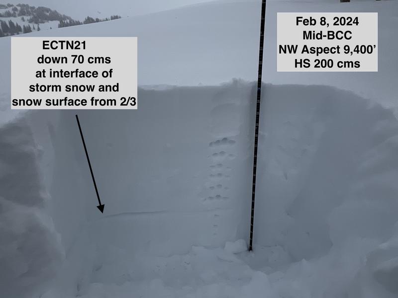
Travel today was Beartrap Fork, Desolation Ridgeline / Desolation Lake, and Park City Ridgeline. Overall, instabilities within the storm snow are settling out and should continue to on Friday and into this weekend. The weakest snow I was finding was down 70 cms at the interface with the storm snow from this week and the old snow surface, but ECT scores were all ECTN (no propagation) with poor quality shears at the fracture.
Visibility was poor today, but a bit of clearing provided this glimpse of West Desolation Ridgeline.
Today's Observed Danger Rating
Considerable
Tomorrows Estimated Danger Rating
Considerable
Coordinates