Forecast for the Uintas Area Mountains

Craig Gordon
Issued by Craig Gordon for
Tuesday, March 26, 2024
MID MORNING HEADS UP-
A band of enhanced snowfall bumped the avy danger up a notch since o'dark thirty and it's more touchy than expected.
At mid and upper elevations aound the dial you'll find MODERATE avalanche danger. Human triggered storm snow avalanches are POSSIBLE on sustained, steep slopes.
Low elevation terrain offers LOW avalache danger and human triggered avalanches are UNLIKELY.

Low
Moderate
Considerable
High
Extreme
Learn how to read the forecast here
Special Announcements
Please help support the UAC rebuild our website backend platform to ensure the ongoing security of the website and the data stored on the site by donating to our spring campaign. Save lives by making a donation today!
Weather and Snow
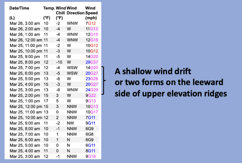
Nowcast- Overnight, a little wiggle in the jet stream did its wiggle thing and delivered a couple traces of snow across the range. Though in fairness to the said wiggle... a few favored areas stacked up close to an inch of snow. A break in the clouds reveals a waning Worm Moon as temperatures hover in the mid teens. Winds are light and blow from the west and northwest, clocking in at 10-15 mph near the peaks. Riding and turning conditions are quite good, especially on wind sheltered, upper elevation slopes facing the north half of the compass.
Forecast- Partly cloudy skies are on tap for a good portion of the morning, but another round of snow is expected to roll in late this afternoon. High temperatures climb into the upper 20's while winds blow 15-25 mph from the west and northwest along the high ridges. Overnight lows dip into the teens.
Futurecast- A break in the action is slated for Wednesday with unsettled weather in the queue rounding out the workweek.
Recent Avalanches
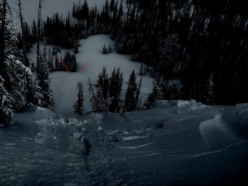
I thoroughly appreciate Uinta local Micheal J's backcountry obs. Over the weekend, MJ stomped on a small piece of overhanging cornice in the Hoyt Peak environs, which in turn triggered a shallow wind drift on the slope below. Arrows indicate the small avalanche ran a bit further than you might expect.

For all Uinta observations and archived avalanche activity click HERE.
Ad
Avalanche Problem #1
New Snow
Type
Location
Likelihood
Size
Description
The snowpack is deep, it's homogeneous, it's happy in its own skin, and it's generally bomb dot com. Yeah... avy danger is straight-forward and there's plenty of room to roam on a go-anywhere base.
A couple things to consider as we stretch our wings-
Image above, 24 hour data dump from Windy Peak (10,662')
  • A handful of shallow wind drifts formed on the leeward side of upper elevation ridges late yesterday and may still be sensitive to our additional weight. Hardly big enough to bury us, shallow drifts running on a slick bed surface under the storm snow may pack enough punch to catch us off guard in sustained, steep terrain.
  • It's spring and weather changes on a dime and often, from one drainage to another. Remember ... during times of heavy snow showers or intense sunshine the surface snow will come to life.
Additional Information
The Uinta weather station network was upgraded this summer and all that real-time info is found HERE. Simply click on "western Uinta" tab and then "weather stations" tab.

We are always looking for snow and avalanche observations or just general riding conditions. So... if you see something, say something. You can reach me directly at [email protected] or 801-231-2170.
Also, if you're looking for more avy education opportunities for yourself, your crew, or your club please don't hesitate to reach out to me and we'll find a presentation, class, or clinic for ya!
General Announcements

Re-issued at 10:50 on Tuesday, March 26th this forecast will be updated by 0700 Wednesday, March 27th, 2024.
This forecast is from the U.S.D.A. Forest Service, which is solely responsible for its content. This forecast describes general avalanche conditions and local variations always occur.