Forecast for the Provo Area Mountains

Dave Kelly
Issued by Dave Kelly for
Monday, March 25, 2024
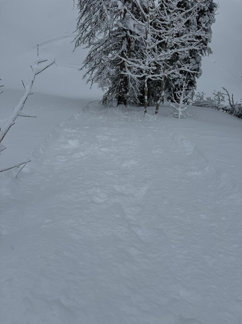
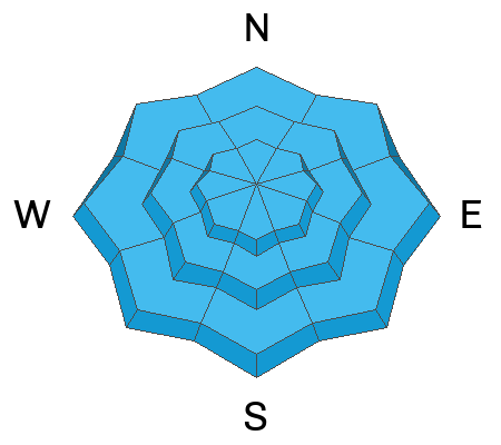
There is a MODERATE avalanche danger on all aspects at the mid and upper elevations where human triggered soft slab avalanches are possible. The avalanche danger is LOW in lower elevation terrain.
Today, avalanches will fail on a density change within the newest snow. During periods of heavy snowfall or wind transporting snow the likelihood of triggering an avalanche will increase.
Low
Moderate
Considerable
High
Extreme
Learn how to read the forecast here
Special Announcements
Support the UAC website backend platform to ensure the ongoing security of the website and the data stored on the site rebuild by donating to our spring campaign.
Weather and Snow
Currently under partly cloudy skies temperatures are in the mid 20's °F. Winds are blowing lightly at most mountain locations. There was a trace to an 1" of new snow overnight. Storm totals in select locations are 8"-12" of snow and .50"-.84" of snow water equivalent. In many lower elevation locations in Provo the storm started as rain yesterday morning leading to lower snowfall amounts.
Today, look for partly cloudy skies with increasing clouds and precipitation this afternoon. Temperatures are forecast to be 32-38°F with winds blowing from the north-northwest 10 gusting to 15 MPH at the 9,000' ridge-lines and 20 gusting to 25 MPH at the 11,000' ridge-lines. Look for a trace-1" of new snow with the off chance of 1"-3" and up to .30" water in select areas with increasing snowfall rates and winds this afternoon. There is a chance of lightning with the storm passing through. The freezing level should stay around 5,000' which means that with cloudy skies and colder temperatures the snow surface will stay soft making for excellent travel today.
Read the updated forecast discussion from our partners at the National Weather Service HERE.
Recent Avalanches
Yesterday, north of the Provo forecast region there were 16 avalanches reported to the Utah Avalanche Center. Most of these avalanches were human triggered and running on a density change within the newest snow, 4"-10" deep. Some of these soft slab avalanches were breaking 10'-15' above backcountry travelers and in a few cases where people were caught and carried, they lost gear. There were reports of an increase in these avalanches during times of heavier snowfall.
Photo of a 6" deep intentionally triggered soft slab avalanche in Snake Creek on an east facing slope at 7,800'
Read all the observations HERE.
Ad
Avalanche Problem #1
New Snow
Type
Location
Likelihood
Size
Description
Yesterday's new snow was very reactive to riders. The layer of weakness in most cases was a density change a couple of inches above the melt-freeze crust or associated with increased snowfall rates throughout the day. This weak layer in the new snow was starting to settle out below 8,000' where it became more difficult to trigger avalanches as the day went on.
Today, it will be more difficult but not impossible to trigger a new snow avalanche failing on a density change within the newest snow. Any new snow that comes in this afternoon will be sensitive to backcountry travelers on steep slopes. IF the slope has had any wind affect it will be much more sensitive and like we saw yesterday you may be able to trigger soft slab avalanches 10"-14" deep breaking above you.
When an avalanche breaks above you vs at your skis or board it is more dangerous because you are now part of that avalanche and have less control over how you move through that terrain. Soft slab avalanches have enough power and oomph to take you of your feet and in terrain where they have the potential to gather more snow debris, piles can be quite deep.
Avalanche Problem #2
Normal Caution
Type
Location
Likelihood
Size
Description
Springtime in the mountains. What this means is that like the last weekend at your favorite ski resort most anything goes. You may see new snow avalanches, wind-drifted snow avalanches, wet snow avalanches, green-housing (filtered sun creating rapid warming of the snowpack at all elevations and aspects), glide avalanches, and thunder snow.
It's the time of year when it's easy to fall back on heuristic traps based on past experience, particularly familiarity. Keep your head about you when traveling in the mountains as even a small avalanche could have real consequences. Read more about heuristics and decision making from local avalanche researcher Ian McCammon HERE.
General Announcements
This information does not apply to developed ski areas or highways where avalanche control is normally done. This forecast is from the U.S.D.A. Forest Service, which is solely responsible for its content. This forecast describes general avalanche conditions and local variations always occur.