Forecast for the Provo Area Mountains

Nikki Champion
Issued by Nikki Champion for
Thursday, March 21, 2024
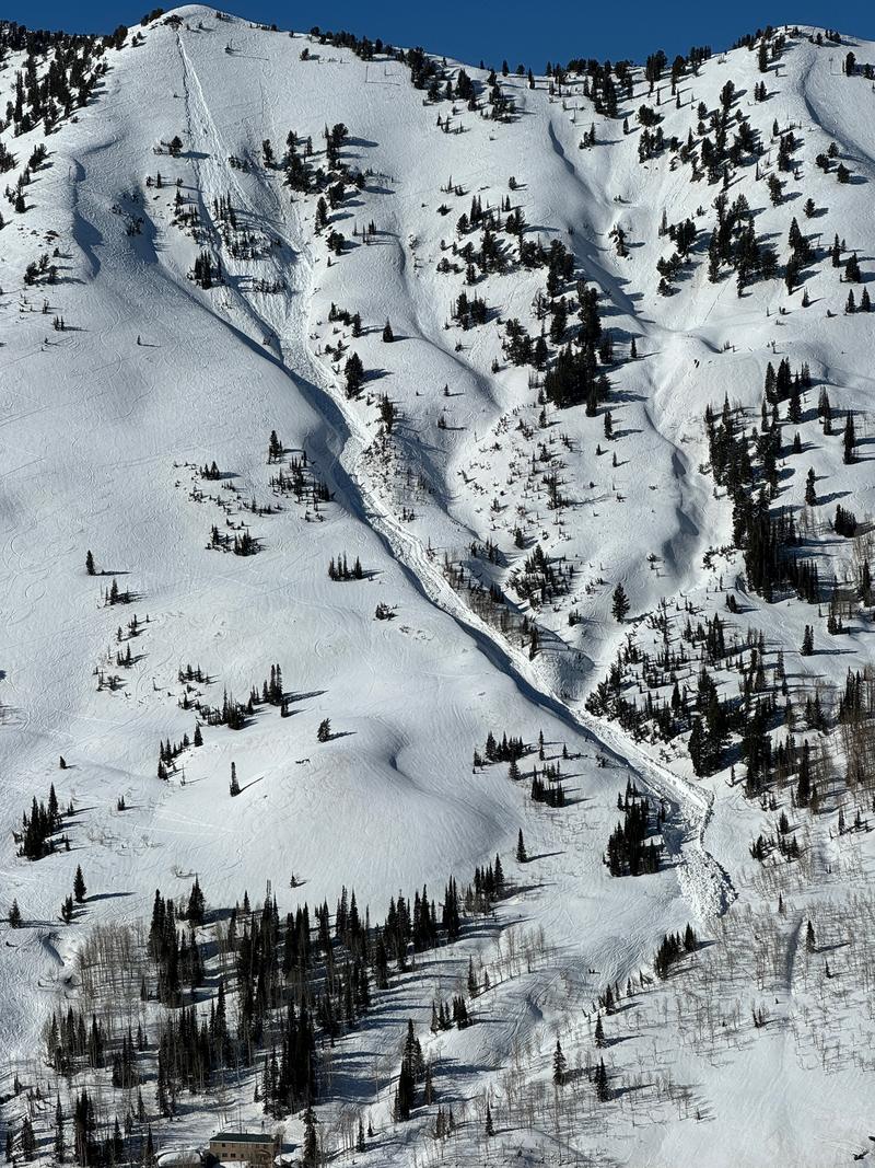
The avalanche danger is currently LOW this morning. However, with a poor overnight refreeze and temperatures expected to climb well into the 40s F, the danger may rise to MODERATE for wet snow avalanches on steep solar aspects and some lower and mid elevation polar aspects during periods of strong sunshine before a weak front moves through the area late this afternoon.
Watch for changing conditions; once the snow becomes wet, unsupportable, and unstable, it's time to move off of these aspects.
Avoid traveling on or underneath corniced ridgelines, as cornices may collapse due to warming. Terrain prone to glide avalanches should also be avoided.
Low
Moderate
Considerable
High
Extreme
Learn how to read the forecast here
Special Announcements
Support the UAC website backend platform to ensure the ongoing security of the website and the data stored on the site rebuild by donating to our spring campaign. Save lives by making a donation today!

The Utah Avalanche Center is hosting The Banff Film Festival on Thursday, March 21, and Friday, March 22 in Moab.
Weather and Snow
This morning, under scattered skies, temperatures range from the mid 30s to mid-40s °F, without any periods of temperatures below freezing overnight in most areas. Westerly winds have increased to near 10 mph with gusts near 15 mph at most elevations, and gusts near 25 mph at the uppermost elevations.
Today will be mostly sunny, becoming partly cloudy with isolated snow showers. It will be another warm day, with strong sunshine and temperatures rising well into the upper 40s. Winds will be from the west and rising a bit, with gusts around 40 mph. Wind, sun, and warm temperatures have taken a toll on snow surfaces, but dry, chalky snow may still be found on upper-elevation northerly aspects and a few hours of corn in the late morning hours.
Outlook: A strong cold front is forecasted to cross the area Saturday afternoon into Saturday evening, bringing a period of heavy snow. Anticipate a shift to northwest flow following the front. There might be a period of light or no precipitation Sunday morning before widespread snow showers redevelop in the afternoon, spurred by the spring sun's heating.
Recent Avalanches
Continued reports of small point releases, rollerballs, and pinwheels on many aspects during periods of afternoon heating.
While very few reports have come in from the Provo area mountains. In the Flagstaff Gully, a natural wet loose avalanche occurred, triggered by an unknown factor, potentially linked to a rock pile above the starting zone, resulting in a 14-inch deep, 100-foot wide avalanche with a vertical drop of 1,250 feet, depositing 15-20 feet of wet debris on the mining road above the town of Alta.
Photo of the Flagstaff natural wet-loose avalanche that entrained a lot of snow. D. Kelly
Check out all recent Observations HERE.
Ad
Avalanche Problem #1
Wet Snow
Type
Location
Likelihood
Size
Description
The increased winds, slightly cooler temperatures, and approaching front should minimize wet snow occurrences compared to earlier this week. However, temperatures are still expected to reach the upper 40s, accompanied by strong sunshine. During these sunny periods, avalanches involving wet snow are likely, especially on steep slopes facing east/south/west and low and mid elevation northerly terrain as temperatures rise. Wet snow can be managed by moving to shadier slopes once the surface heats up. Watch for signs like rollerballs and sluffing.
Avoid traveling under large cornices, as they may collapse due to heating. Glide avalanches remain a concern in areas like Stairs Gulch, Broads Fork, Mill B South, and Mineral Fork.
"Slide for life" conditions will become present with the incoming cooler temperatures, causing previously damp surfaces to freeze solid, making self-arrest nearly impossible. Ensure you have sharp equipment and the necessary skills for self-arrest if traveling on these slopes.
General Announcements
This information does not apply to developed ski areas or highways where avalanche control is normally done. This forecast is from the U.S.D.A. Forest Service, which is solely responsible for its content. This forecast describes general avalanche conditions and local variations always occur.