Forecast for the Moab Area Mountains

Dave Garcia
Issued by Dave Garcia for
Wednesday, April 3, 2024
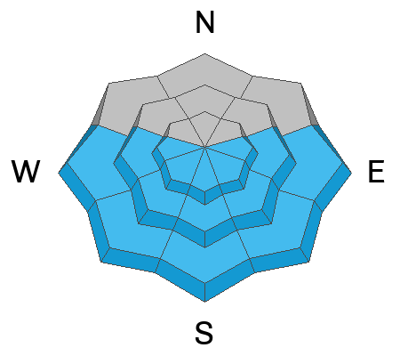
The overall avalanche danger is MODERATE. Slabs of wind-drifted snow exist on all aspects above treeline. Strong NE winds yesterday morning deposited fresh slabs on leeward slopes. Additionally, it is still possible to trigger lingering wind slabs on Northerly aspects that were formed on Sunday.
Solar aspects will start with a LOW danger, but the danger will rise to MODERATE for wet-snow avalanches with daytime heating. Be aware of changing conditions on solar aspects today.
Low
Moderate
Considerable
High
Extreme
Learn how to read the forecast here
Special Announcements
Road Conditions: The lower end of the Geyser Pass road is now mostly dry dirt. Melting snow on the upper end will make for sloppy and muddy conditions later in the day.
Grooming: The trail into Gold Basin was rolled out Monday.
Weather and Snow
6:00 a.m. Snow and Weather Data
24 Hour Snow 0" 72 Hour Snow 7" Season Total Snow 190" Depth at Gold Basin 64"
Winds on Pre-Laurel Peak: 7-12 NNW Temp 22° F Percent of Normal: 139%

Weather
Under clear skies this morning it is 22 degrees in Gold Basin. Overnight winds have been light out of the NNW. Winds will shift to the WNW today and blow 5-10 MPH. Expect sunny skies, with 10,000' high temperatures around 32 degrees. Overnight lows will drop to 24 degrees, winds will shift to the SW and increase overnight. SW flow aloft allows warm air to move in and temperatures will continue to be on the rise tomorrow. Highs will be in the mid-30's on Thursday and SW winds will blow 20-25, increasing to 30-35 later in the day. SW winds will continue to increase and are forecast to blow in the 50 MPH range on Friday, with stronger gusts possible. These strong winds are ahead of a closed low that moves into the Great Basin on Friday. This system brings a cold front with it over the weekend. Temperatures will crash Friday night, and we will see a chance for snow Friday night into Saturday.
General Conditions
Skiing and riding conditions are still quite good in some areas, while other areas have been hammered by the wind. Strong Southerly winds early in the week stripped snow from the solar aspects and deposited slabs of wind-drifted snow on leeward slopes. Early morning yesterday, strong Northeast winds were blowing and drifting large amounts of snow onto South and West aspects above treeline. Because of these shifting wind directions, skiers and riders should be on the lookout for fresh slabs of wind-drifted snow on all aspects above treeline. The slabs that formed on Sunday have been stabilizing, but there may still be some places in the alpine where it is possible to trigger one of these older slabs. For quality skiing, sheltered, North-facing terrain remains your best bet. In my travels yesterday, I was able to find great turning in cold powder on some exposed North-facing slopes, while other open slopes were obviously affected by the strong Northeast winds.
Slabs of wind-drifted snow continue to be your main avalanche problem. In our recent travels, Eric and I have found wind slabs on top of weak, faceted layers of snow in areas with a shallow snowpack. This weak structure is not widespread, but it exists on some slopes that have previously avalanched this season.
Strong April sunshine, and warm temperatures will make wet avalanche activity possible today. When the snow gets wet and saturated on the sunny slopes, it is time to move to a different aspect.
Snowpack and Weather Data
Gold Basin Storm Stake (10,000')
Gold Basin SNOTEL site (10,000')
SNOTEL site near Geyser Pass Winter Trailhead (9600')
Wind Station on Pre-Laurel Peak (11,400')
NWS forecast for the La Sal Mountains.
Recent Avalanches
Click here to see the La Sal avalanche database. Prudent backcountry travelers will want to know what slopes have previously avalanched, as some of these slopes hold shallow, weak snow.
Ad
Avalanche Problem #1
Wind Drifted Snow
Type
Location
Likelihood
Size
Description
Strong NE winds on Tuesday morning whipped up a fresh round of wind-drifted snow above treeline. Deposition occurred primarily on South and West aspects, but strong mountain winds can swirl and change direction, and sensitive drifts may exist on all aspects. Cracking and collapsing will be obvious signs of instability. Ski-cutting slopes is an effective tool for recently formed, sensitive wind drifts.
Lingering slabs that formed on Sunday still exist on Northerly aspects in the alpine. These slabs have been stabilizing over the last few days, but the possibility of triggering one of these older slabs still exists. Continue to avoid fat, round looking pieces of snow above treeline.
In shallow snowpack areas, slabs of wind-drifted snow exist on top of weak, faceted snow. These areas include slopes that have previously avalanched. When in doubt, grab your probe to check for depth. If the snowpack is shallow, grab your shovel and look for faceted snow.
This photo was taken Tuesday morning. Strong NE winds were blowing and drifting snow onto leeward slopes above treeline.
Avalanche Problem #2
Wet Snow
Type
Location
Likelihood
Size
Description
Solar aspects will start the day with LOW danger this morning. Be alert to changing conditions as the day heats up. With warm temperatures in the forecast, and strong April sunshine, wet-loose activity will become possible. Signs of wet activity include roller balls, pinwheels, wet, slushy snow, or your boots sinking deep into the snow. When you observe these signs, it is time to head over to Northerly aspects.
Additional Information
Want some more insight into the La Sal Mountains as well as the communal impacts of a tragic avalanche? Check out the latest UAC podcast with forecaster Eric Trenbeath where he discusses the range, it's often treacherous snowpack, and how the devastating avalanche in February, 1992, affected the Moab community.
Our avalanche beacon checker sign and beacon training park are up and running. A huge thanks to Talking Mountain Yurts for sponsoring those this season!
Sign up for forecast region-specific text message alerts. You will receive messages about changing avalanche conditions, watches, warnings and road plowing closures.
Follow us on Instagram @utavy_moab
General Announcements
This forecast is from the U.S.D.A. Forest Service, which is solely responsible for its content. This forecast describes general avalanche conditions and local variations always occur.