Forecast for the Moab Area Mountains

Dave Garcia
Issued by Dave Garcia for
Tuesday, March 19, 2024
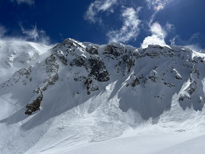
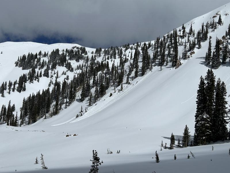
The overall avalanche danger is MODERATE, and there are three different problems to look out for today.
  • Your primary concern is recently formed slabs of wind-drifted snow that exist near and above treeline on slopes that face NW-N-NE-E. These wind slabs have produced widespread natural activity, and remain sensitive to the weight of skiers and riders.
  • In isolated areas on northerly aspects near treeline and below, weak faceted snow exists two feet below the surface. The distribution of this layer is spotty at best, but it deserves to be on your radar today.
  • With a strong March sun and forecast warm temperatures, we'll see a rising MODERATE danger for loose, wet avalanches on sun exposed slopes as the day heats up. Signs of instability include rollerballs, pinwheels, and sloppy wet snow.
Low
Moderate
Considerable
High
Extreme
Learn how to read the forecast here
Special Announcements
Road Conditions: The Geyser Pass Road was plowed on Monday 3/18.
Grooming: Trails have not been groomed
***Support the UAC website rebuild by donating to our spring campaign. Save lives by making a donation today! HERE

The Banff Film Festival is returning to Moab on Thursday 3/21 and Friday 3/22 For tickets and information visit our event page.
Weather and Snow
6:00 a.m. Snow and Weather Data
24 Hour Snow 0" 72 Hour Snow 7" Season Total Snow 168" Depth at Gold Basin 65"
Winds on Pre-Laurel Peak: ESE 1 - 4 Temp 20° F Percent of Normal: 122%

Weather
The nearly stationary closed low that has been parked over the Desert Southwest for almost a week is on its way out. Today will be mostly sunny, with some clouds moving in between noon and five, and a 20% chance of snow showers. No accumulation is expected. Winds will remain light, blowing just 5-10 MPH out of the SE, and shifting to the NW later this afternoon. High temperatures will be around 28 degrees. Wednesday will be sunny with a high of around 30, and NW winds remain light at 5-15 MPH. A gradual warming trend this week will see high temperatures climbing to 5-10 degrees above normal by Friday and Saturday. A storm system looks to bring more widespread precipitation and cooler temps Sunday into early next week.
General Conditions
Skiing and riding conditions remain excellent, with 22 inches of new snow since Wednesday morning. Warm temperatures and strong March sunshine have certainly affected solar aspects, and you can expect them to be crusted over this morning. We will see plenty of sunshine again today, and I expect another round of wet-loose activity on the Solars. Strong winds during the storm drifted the new snow, and many natural wind slab avalanches have been observed. Alpine terrain is not completely off-limits, but you will need to have a keen eye for observing and avoiding fat rounded pillows of drifted snow. In our travels yesterday, we found the recent slabs of drifted snow to be reactive to our weight and stability tests.
The weak layer of faceted snow that we have been tracking since 3/8, is still popping up in isolated areas. This layer is about two feet below the surface, and it exists in steep, sparsely treed, north-facing terrain near treeline and below. The distribution of this layer is spotty at best, but backcountry travelers should exercise caution when entering steep loosely treed slopes. When you do find this layer, it tends to be very obvious. Yesterday, we had a small collapse associated with this weak layer.
Snowpack and Weather Data
Gold Basin Storm Stake (10,000')
Gold Basin SNOTEL site (10,000')
SNOTEL site near Geyser Pass Winter Trailhead (9600')
Wind Station on Pre-Laurel Peak (11,400')
NWS forecast for the La Sal Mountains.
Recent Avalanches
In our travels on Sunday and Monday, we observed numerous avalanches that ran during the storm. Most of these avalanches involve slabs of wind-drifted snow. For a full updated list of recent avalanche activity click here.
This avalanche in Talking Mountain Cirque, appears to have failed deeper on a layer of facets. It is also possible that this avalanche in Horse Creek Chutes may have failed on facets as well. Both of these slopes are repeat runners, meaning they avalanched previously this season, leaving behind a shallow and weak snowpack.
The photo below shows recent avalanches in wind-drifted snow in the Meat Cleavers of Middle Cirque.
Ad
Avalanche Problem #1
Wind Drifted Snow
Type
Location
Likelihood
Size
Description
Strong easterly winds early in the storm cycle easily blew and drifted snow onto many slopes near treeline and above. Primary deposition occurred on slopes that face NW-N-NE-E. In our travels yesterday, we encountered drifts up to two feet deep. These fresh drifts remain sensitive to the weight of a human, and it is possible to trigger avalanches up to two feet deep. If you are navigating through alpine terrain today, keep an eye out for fat, rounded, pillowy looking slabs of snow. Wind-drifted snow is stiffer and more compacted than non-drifted snow, and you will feel the difference if you cross onto a wind slab. Shooting cracks in drifted snow are a sure sign of instability.
Avalanche Problem #2
Wet Snow
Type
Location
Likelihood
Size
Description
A strong March sun will rapidly warm sun exposed slopes today, and we'll see a rising danger for loose, wet avalanche activity. Be alert to signs of loose, wet snow instability such as rollerballs or pinwheels, and stay off of, and out from under steep slopes if they become wet and sloppy.
Additional Information
Want some more insight into the La Sal Mountains as well as the communal impacts of a tragic avalanche? Check out the latest UAC podcast with forecaster Eric Trenbeath where he discusses the range, it's often treacherous snowpack, and how the devastating avalanche in February, 1992, affected the Moab community.
Our avalanche beacon checker sign and beacon training park are up and running. A huge thanks to Talking Mountain Yurts for sponsoring those this season!
Sign up for forecast region-specific text message alerts. You will receive messages about changing avalanche conditions, watches, warnings and road plowing closures.
Follow us on Instagram @utavy_moab
General Announcements
This forecast is from the U.S.D.A. Forest Service, which is solely responsible for its content. This forecast describes general avalanche conditions and local variations always occur.