Forecast for the Moab Area Mountains

Dave Garcia
Issued by Dave Garcia for
Tuesday, February 27, 2024
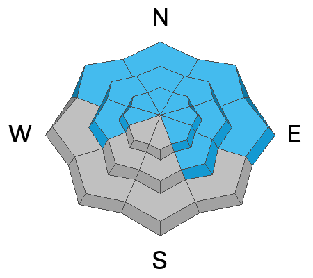
A quick-moving storm brings very strong winds and a few inches of new snow to the range. The avalanche danger is MODERATE and it is POSSIBLE to trigger avalanches in fresh slabs of wind-drifted snow on all aspects near treeline and above.
Although it is becoming less likely, very deep and dangerous avalanches failing on a persistent weak layer remain POSSIBLE on slopes that face W-N-E-SE. The danger is most prominent on slopes that face NW-N-NE-E and you are most likely to trigger one of these avalanches in thin snowpack areas.
Low
Moderate
Considerable
High
Extreme
Learn how to read the forecast here
Special Announcements
We are seeking a passionate individual to join us as Executive Director of the nonprofit Utah Avalanche Center. Click here for more information.
Road Conditions: The Geyser Pass Road is plowed, expect the surface to be frozen and slick today.
Grooming: Trails have not been groomed in over a week.
Weather and Snow
6:00 a.m. Snow and Weather Data
24 Hour Snow 0" 72 Hour Snow 0" Season Total Snow 132" Depth at Gold Basin 47"
Winds on Pre-Laurel Peak: WSW 29 G 34 Temp 27° Percent of Normal: 93%

Weather
Today will be a cold and windy day in the mountains. 10,000' temperatures will drop to around 20 degrees. Winds will shift, and blow out of the WNW at 35-45 MPH. Snow showers will develop this morning, and the mountains should pick up 3-5" of snow by the end of the day. Temperatures crash to 0 degrees overnight, and strong NW winds continue until the midnight hour. The winds will eventually back off in the early morning. Tomorrow will be sunny with WSW winds blowing 10 MPH and high temperatures will rise to the mid-twenties.
General Conditions
In my travels yesterday, I found a mixed bag of snow surface conditions. Solar aspects are a mix of sun and wind crusts. Any new snow we get today will not bond well to these surfaces. If we accumulate enough snow, there is the potential for fast-running sluffs in steep terrain on these aspects. Soft snow still exists on Northerly aspects, but it is largely wind-affected. The mountains are in need of a refresh, and hopefully, today's storm will deliver. Your best bet for soft turns will be sheltered terrain. Strong SW winds will blow and drift snow into fresh slabs throughout the day. Yesterday, I found the winds to be swirling in all directions. You should anticipate shallow and sensitive slabs of wind-drifted snow on all aspects near treeline and above. It remains possible to trigger very deep avalanches breaking down to our early season persistent weak layer. You are most likely to trigger one of these avalanches high in the alpine in steep, rocky, radical terrain with a shallow snowpack.
I poked around at a variety of aspects yesterday to get a lay of the land ahead of today's storm. You can read my report here.
Snowpack and Weather Data
Gold Basin Storm Stake (10,000')
Gold Basin SNOTEL site (10,000')
SNOTEL site near Geyser Pass Winter Trailhead (9600')
Wind Station on Pre-Laurel Peak (11,400')
NWS forecast for the La Sal Mountains.
Ad
Avalanche Problem #1
Wind Drifted Snow
Type
Location
Likelihood
Size
Description
SW winds have blown in the moderate to strong range for the past 36 hours. Today will be the peak of the winds and they will blow 35-45 MPH. Mountain winds of this speed and duration tend to swirl in all directions as they navigate the terrain. These strong winds will easily blow and drift any new snow into fresh, sensitive slabs on all aspects near treeline and above. Look for fresh drifts around any terrain features that facilitate loading, such as gully walls, under cliff bands, along sub-ridges, in scoops, saddles, and sinks. Cracking is a good indication that you have skied out onto a fresh drift.
Avalanche Problem #2
Persistent Weak Layer
Type
Location
Likelihood
Size
Description
Today's storm will not be enough to affect the deeply buried persistent weak layer. It will take the weight of a human in just the right spot to trigger one of these avalanches. Likely trigger points are steep, rocky, radical terrain with a shallow snowpack. The odds of triggering one of these slides continue to decrease, but it is not impossible. If you were to trigger one of these avalanches, it would break out deep and wide, and could be potentially unsurivable. Stack the odds in your favor by skiing in areas with a deeper snowpack.
Additional Information
Want some more insight into the La Sal Mountains as well as the communal impacts of a tragic avalanche? Check out the latest UAC podcast with forecaster Eric Trenbeath where he discusses the range, it's often treacherous snowpack, and how the devastating avalanche in February, 1992, affected the Moab community.
Our avalanche beacon checker sign and beacon training park are up and running. A huge thanks to Talking Mountain Yurts for sponsoring those this season!
Sign up for forecast region-specific text message alerts. You will receive messages about changing avalanche conditions, watches, warnings and road plowing closures.
Follow us on Instagram @utavy_moab
General Announcements
This forecast is from the U.S.D.A. Forest Service, which is solely responsible for its content. This forecast describes general avalanche conditions and local variations always occur.