

Forecast for the Logan Area Mountains

Issued by Toby Weed on
Thursday morning, April 4, 2024
Thursday morning, April 4, 2024
Overnight temperatures stayed well above freezing at all stations, and it will be even warmer in the mountains today than yesterday. The avalanche danger will rise to CONSIDERABLE on sunny slopes steeper than 30°. Dangerous conditions will develop with natural wet avalanches becoming likely and large cornice falls possible off the high ridges. People could trigger large, dangerous wet avalanches, especially in steep rocky terrain. There is also an elevated danger of triggering hard wind slab avalanches in some drifted upper-elevation terrain.
- Evaluate snow and terrain carefully and make conservative decisions.
- Avoid being on or under slopes with melt-softened saturated snow, and stay out from under large overhanging cornices that may fail in the heat of the day.

Low
Moderate
Considerable
High
Extreme
Learn how to read the forecast here
 Special Announcements
Donate today to help us rebuild our website backend platform to ensure uninterrupted access to avalanche information and the ongoing security of the website and the data stored on the site.
 Weather and Snow
Winds blowing from the south-southeast increased significantly overnight, likely producing shallow hard wind slabs of drifted snow in upper-elevation terrain. Temperatures stayed well above freezing at all stations overnight, and a superficial refreeze overnight has likely only formed a shallow surface crust in many areas, which will soften earlier this morning. Solar heating, potential greenhousing, and seasonal warmth will elevate the potential for dangerous wet avalanches that could entrain heavy piles of moist or saturated snow.
The Tony Grove Lake Snotel at 8400' reports a toasty 40° F this morning, and there is 99 inches of total snow at the site containing 122% of normal snow water equivalent.
At the 9700' CSI Logan Peak weather station, winds increased overnight, and at 5:00 AM, they were blowing from the south-southeast 36 mph with gusts in the mid-50s, and it was 36° F.
At our new Paris Peak weather station at 9500', it's 35 °F, and the wind blows from the south at 6 mph with gusts in the teens.
It's 38° F at our new Card Canyon weather station at 8800', and there is 86 inches of total snow.
Today, expect increasingly warm temperatures, mostly sunny skies, and breezy conditions in the mountains. Snow showers are likely tomorrow, with 4 to 6 inches of accumulation possible up high. Temperatures should drop into the twenties, and it will be breezy, with 20 to 30 mph winds blowing from the south. Snow showers are expected to continue Friday night and Saturday with another 4 to 8 inches possible.
For more information, visit our mountain weather page HERE
 Recent Avalanches
On Monday, a rider triggered a small, not unexpected, soft wind slab in a steep chute on a NE facing slope at 9200' in the Central Bear River Range. report
From the Highway in Sardine Canyon Tuesday afternoon, we could see large piles of fresh wet avalanche debris beneath Mitton Peak. More natural wet avalanches occurred yesterday in sunny terrain across the zone.
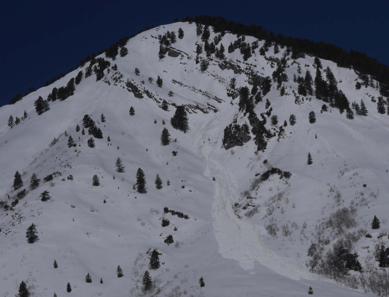 A good-sized natural wet avalanche that ran on Tuesday off Mitton Peak in the Wellsville Range is visible from Hwy 89/91.
Check out all local observations and avalanches HERE.

Avalanche Problem #1
Wet Snow
Type
Location

Likelihood
Size
Description
Intense sun will cause the risk of wet avalanches to increase rapidly today. Solar heating, potential greenhousing, and seasonal warmth will cause the snow to be soft and saturated throughout and prone to producing wet avalanches. Despite being rather slow-moving compared to dry avalanches, these could entrain large piles of heavy snow and grow to become large and dangerous avalanches on sustained slopes.
- If you are sinking deeply into wet/moist snow, move to a lower-angle slope or cooler aspect or elevation.
- Avoid being on or under steep slopes with moist or saturated snow. Collapsing or whumpfs and shooting cracks are red flags indicating unstable snow.
- Be aware of terrain traps below like trees, gullies, sinks, or rock outcroppings that wet avalanches could sweep you into.
- The heat will cause large overhanging cornices on the major ridges to sag and buckle, and some of these could calve off large chunks, perhaps causing avalanches on slopes below.
- Practice safe travel protocols to avoid exposing more than one person to avalanche danger.
Avalanche Problem #2
Wind Drifted Snow
Type
Location

Likelihood
Size
Description
Winds blowing from the south-southeast increased significantly overnight. Despite a lack of apparently transportable snow, these probably created hard wind slabs of drifted snow in some upper-elevation lee-slope terrain. Hard wind slabs can be devious, often allowing people to get out on them before releasing, like a big mouse trap.
Additional Information
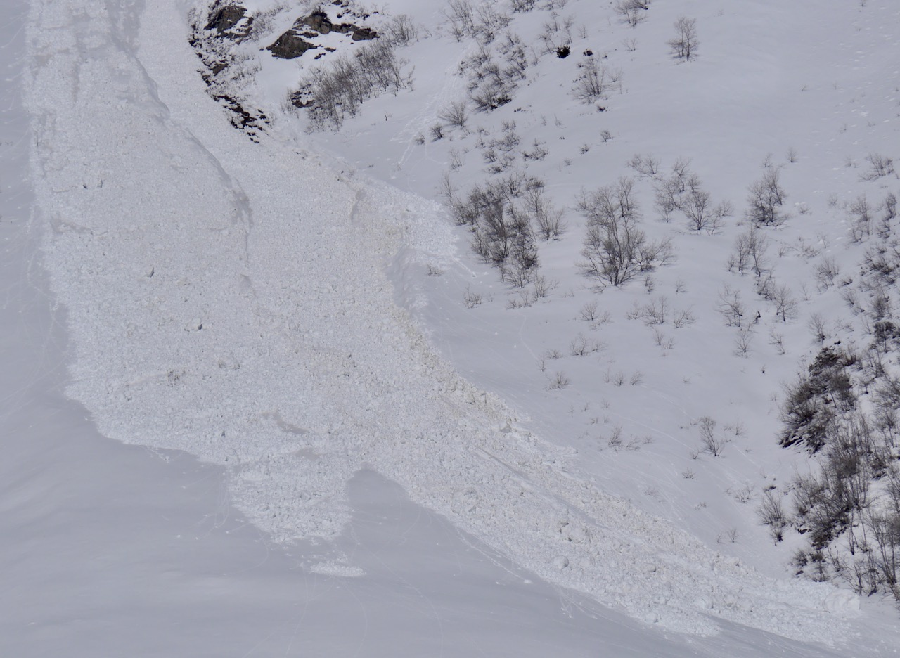
Large piles of fresh wet avalanche debris can be seen below Mitton Peak in the Wellsville Mountain Wilderness.
***Check out McKinley Talty's new blog post, "Do We Let Our Guard Down in the Spring?" about springtime mindsets and avalanche incidents... HERE
General Announcements
-National Forest Winter Recreation Travel Maps show where it's open to ride: UWCNF Logan, Ogden LRD Tony Grove, Franklin Basin CTNF Montpelier
-Sign up for forecast region-specific text message alerts. You will receive messages about changing avalanche conditions, watches, and warnings...HERE.
-For all questions on forecasts, education, Know Before You Go, events, online purchases, or fundraising, call 801-365-5522.
-To report an avalanche or submit an observation from the backcountry, go HERE.
-Come practice companion rescue at the Franklin Basin TH Beacon Training Park. It's free and open to everyone. For easy user instructions, go HERE.
-We will issue regular daily updates of our forecast through April 14.
-We will update this forecast tomorrow by 7:30 AM.
This forecast is from the U.S.D.A. Forest Service, which is solely responsible for its content. This forecast describes general avalanche conditions, and local variations always occur.