Forecast for the Logan Area Mountains

Toby Weed
Issued by Toby Weed for
Wednesday, January 24, 2024
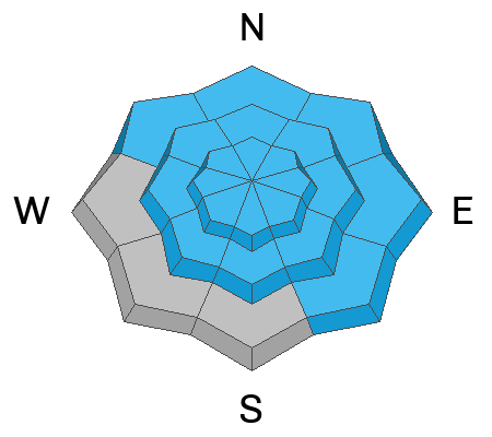
Elevated avalanche conditions exist, and people could trigger dangerous slab avalanches up to four feet deep and a couple hundred feet wide, failing on a buried persistent weak layer, especially where the snow is relatively shallow and in steep rocky terrain. Areas with CONSIDERABLE danger are found on many slopes with poor snow structure at mid and lower elevations and up high in outlying areas like the Wellsville Range, above Bear Lake, and the Logan Peak Area. The danger is MODERATE at upper elevations in the Central Bear River Range, where the heavy snow that fell in January is much deeper, and people are less likely to trigger avalanches.

Careful snowpack evaluation, cautious route finding, and conservative decision-making are essential for safe backcountry travel today.
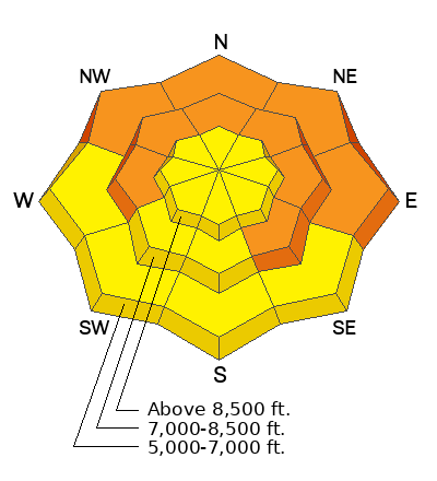
Low
Moderate
Considerable
High
Extreme
Learn how to read the forecast here
Special Announcements
Sign up for forecast region-specific text message alerts. You will receive messages about changing avalanche conditions, watches, and warnings...HERE.
Weather and Snow
Traveling in the backcountry is tricky as the snow gradually stabilizes and avalanche danger slowly decreases. Obvious signs of instability are fewer, but serious human-triggered avalanches, which could be large and destructive, remain likely in some areas. Although less frequently than last week, we are still experiencing and receiving reports of audible collapsing or whumpfs caused by poor snowpack structure in mid and low-elevation terrain. Excellent coverage across the zone makes it easy to find safe areas by staying in terrain less than 30°, off, and out from under steeper slopes. With recent warm temperatures, low-elevation snow is damp, sticky, or crusty, but up higher, the snow is dry, supportable, and fast.

This morning, the wind blows 10-15 mph from the west-northwest at the 9700' CSI Logan Peak weather station. At 9500' on Paris Peak, the wind is blowing 5 to 10 mph from the west, and it’s 19° F.
The Tony Grove Snotel at 8400' reports an inch of new snow. It's 27° F, and there is 78 inches of total snow containing 130% of average SWE (Snow Water Equivalent). Increadibly, the station reports acquiring 12" SWE between January 4 and January 21.

Today, expect high temperatures at 8500' around 29° F, with mostly cloudy skies and a few flurries but little accumulation. Winds will blow lightly from the west-southwest. Snow is likely tonight and Thursday, with 4 to 9 inches of accumulation possible up high and 10 mph wind from the west. Partly cloudy conditions and periods of sunshine are possible on Friday and Saturday.
Recent Avalanches
We received reports of more large naturals that occurred last week in Providence Canyon and several in Cherry Creek Canyon (Mt Naomi Wilderness), including a massive one that ran far and snapped some good-sized trees.
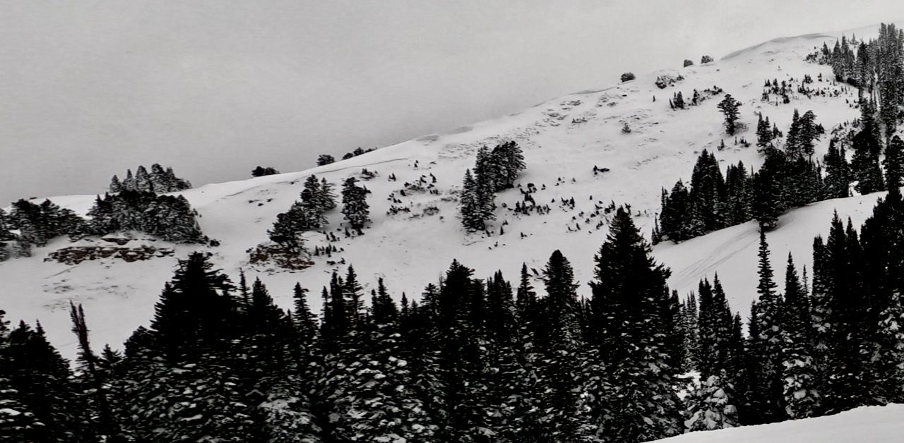
A large natural avalanche that most likely occurred on Thursday, 1-18-24 was observed on Saturday in Three Terraces in upper Providence Canyon.

Check out local observations and avalanches HERE.
Ad
Avalanche Problem #1
Persistent Weak Layer
Type
Location
Likelihood
Size
Description
Today, human-triggered slab avalanches failing on a buried persistent weak layer could be large and life-threatening. During the last storm, heavy snowfall and drifting by winds from the west overloaded slopes plagued by widespread buried layers of weak, sugary snow or facets and feathery surface hoar that developed during the prolonged December dry spell.
  • Avalanches could be triggered remotely, from a distance, or worse, from below.
  • Collapsing or whumpfs and shooting cracks indicate unstable snow.
  • Avalanches are possible even when there are no obvious signs of instability.
  • With unseasonably warm temperatures and rain, the low-elevation snowpack is soft and saturated. Triggering a wet avalanche in terrain with poor snow structure, like the steep banks next to the Logan River, is possible.
Additional Information
We examined the snow at upper elevations in the Central Bear River Range on Monday and found very deep snow.

It's a different story in terrain with shallower snow and a thinner slab layer. On Saturday, we found much more unstable conditions on a mid-elevation east-facing slope above Bear Lake.

Always follow safe travel protocols on or under slopes steeper than 30°.
  • Be sure everyone in your party has working avalanche rescue equipment, including a transceiver, probe, and shovel. Practice with this equipment regularly, and include and instruct new partners.
  • Cross avalanche paths and runout zones one person at a time, with the rest of the party watching from a safe place.
  • Reevaluate and be willing to change your plans if you encounter any signs of instability, like recent avalanches, audible collapses (whumpfs), or cracking in drifted snow.
General Announcements
-Come practice companion rescue with your backcountry partners at the Franklin Basin TH beacon training park. video HERE.
-For all questions on forecasts, education, Know Before You Go, events, online purchases, or fundraising: call 801-365-5522.
-To report an avalanche or submit an observation from the backcountry: go HERE.
-We will update this forecast by 7:30 AM tomorrow.
This forecast is from the U.S.D.A. Forest Service, which is solely responsible for its content. This forecast describes general avalanche conditions, and local variations always occur.