SPECIAL ANNOUNCEMENT |
 |
UDOT in LCC will be test firing the Gazex Avalanche Exploder this morning at 7:30 AM on the north side of the highway above Entry 4 at Snowbird. This will require a brief temporary restriction of the main road and bypass road at Snowbird Entry 4 for approximately 5-10 minutes.
Don't forget to go to our home page calendar to see what's going on this week. We have an avalanche awareness class tonight and again on Thursday with more going on through December. |
|
|
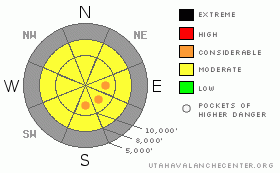
BOTTOM LINE
Danger by aspect and elevation on slopes approaching 35° or steeper.
(click HERE for tomorrow's danger rating)
|
Danger Rose Tutorial
|
Bottom Line for the Salt Lake mountains: The danger is MODERATE with pockets of CONSIDERABLE in areas that received the most snow and are now being wind drifted. This CONSIDERABLE is very isolated and pockety and exclusive to the upper reaches of the Cottonwoods. These suspect areas will be more pronounced on steep upper elevation north through southeast facing slopes and should be handled with kid gloves, if not avoided altogether. Watch as the sun activates some dry loose snow avalanches on the steepest slopes.
Bottom Line for the Ogden, Park City and Provo area mountains: There is a localized MODERATE danger in the uppermost areas for shallow wind drifted snow. These drifts may approach 8-10” deep and will more likely be found on northeast through southeast through south facing slopes. |
|
|
CURRENT CONDITIONS |

|
Vastly improved. Hopefully yesterday's storm was a teaser for what's in store for the weekend. Storm totals across the range are a foot in upper Little Cottonwood, half that in Big Cottowood, and perhaps half that in the outlying areas. Densities are of the cold smoke variety, clocking in at 5%. Temps plummeted with frontal passage and are currently in the single digits at most locations. With the passing of the storm, the winds continue to veer to the north and northeast, though they remain blustery along the highest ridgelines. Hourly averages remain 25-35mph with gusts in the 50's. These remain relegated to the more exposed locales, but will be in the mix for today's avalanche hazard. Riding conditions have improved dramatically with more buffer over the near ubiquitous November 28th rain crust. |
|
|
RECENT ACTIVITY |

|
One of the best days of the year and no obs. Go figure. Wandering the backcountry near the top of Little Cottonwood, we found a shallow natural cycle in the new snow, then subsequently remotely triggered four more soft slabs in the new snow. These were 8” deep and 25-75' wide running on steep northeast to east facing slopes above 10,000'. Last Thursday's 4” of 5% faceted under the clear weather and provided little hospitality to the new snow. I posted a web gallery here. |
|
|
THREAT #1 |

|
| WHERE |
PROBABILITY |
SIZE |
TREND |

|
|
|
|
| |
|
|
Over the next
24 hours.
|
|
|
We have a varied, though interesting, number of weak layers in the snowpack and clearly from yesterday, the old snow/new snow interface was the most hair-trigger. I don't think that we received enough snow to activate the other weaknesses within the snowpack, but it will be a game changer when we do. The sustained stronger northerly winds will continue to drift the loose snow into 1-2' slabs on the lee of the most exposed ridgelines and will be sensitive to the weight of a person or dropped cornice.
|
|
|
THREAT #2 |

|
| WHERE |
PROBABILITY |
SIZE |
TREND |

|
|
|
|
| |
|
|
Over the next
24 hours.
|
|
|
Remotely triggered slides on the Dec 4th layer may still be possible today and ups the ante on what we call 'manage-ability' of the problem. They may break above or adjacent to you and will not be predictable, other than to look for its (as Nancy Pfeiffer from Alaska likes to call it) habitat. Northwest through north through east may be the most likely areas for this trickery. It may be an outlier, but up high where wind drifted, any avalanche release may step down beneath the rain crust. |
|
|
MOUNTAIN WEATHER |

|
We'll see clear skies and rapidly warming temperature as a strong inversion sets in. 8000' temps will rise into the mid-20's with 10,000' temps pushing into the upper teens to low twenties. The warming trend will push 10,000' temps to the low thirties tomorrow. I expect the northerly winds to blow 15-20mph and perhaps twice that at 11,000'. We have a couple weak disturbances through the remainder of the week with a number of storms lined up for the weekend and beyond. |
|
|
GENERAL ANNOUNCEMENTS |
If you want to get this avalanche advisory e-mailed to you daily click HERE.
For the TEXT-only advisory, click here.
UDOT highway avalanche control work info can be found by calling (801) 975-4838. Our statewide toll free line is 1-888-999-4019 (early morning, option 8).
The UAC depends on contributions from users like you to support our work. To find out more about how you can support our efforts to continue providing the avalanche forecasting and education that you expect please visitour Friends page.
If you’re getting out and see anything we should know about please let us know. You can leave a message at (801) 524-5304 or 1-800-662-4140, or email us at uac@utahavalanchecenter.org. (Fax 801-524-6301).
The information in this advisory is from the U.S. Forest Service, which is solely responsible for its content. This advisory describes general avalanche conditions and local variations always occur.
I will update this advisory by 7:30am tomorrow. |
|
|
This information does not apply to developed ski areas or highways where avalanche control is normally done. This advisory is from the U.S.D.A. Forest Service, which is solely responsible for its content. This advisory describes general avalanche conditions and local variations always occur. |
|
This advisory provided by the USDA Forest Service, in partnership with:
The Friends of the Utah Avalanche Center, Utah Division of State Parks and Recreation, Utah Division of Emergency Management, Salt Lake County, Salt Lake Unified Fire Authority and the friends of the La Sal Avalanche Center. See our Sponsors Page for a complete list. |
