SPECIAL ANNOUNCEMENT |
 |
Check out our calendar off the HOME page. We have a three different events coming up this week and next, including some free avalanche awareness talks. Don't miss out on free avalanche education, Powderwhore movies in Park City, and beer from the Red Rock Brewery made especially for the Utah Avalanche Center at the 1st annual Canyon Sports Brewski. |
|
|
BOTTOM LINE
Danger by aspect and elevation on slopes approaching 35° or steeper.
(click HERE for tomorrow's danger rating)
|
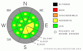
Danger Rose Tutorial
|
There is a MODERATE danger of human triggered avalanches on any slope approaching 35 degrees or steeper with recent deposits of wind drifted snow. These will look smooth and rounded with a hollow sound and will often crack or collapse under your weight. Out of the wind, watch for pockets of loose snow sluffing on steep slopes. |
|
|
CURRENT CONDITIONS |

|
The higher elevations of the Wasatch Range got a mighty 3-5 inches yesterday and overnight, which was mostly graupel, that Styrofoam ball-type of snow. Winds blew hard from the west as the storm approached yesterday afternoon, but most of the precipitation came down after dark and after the winds dropped. Temperatures this morning have dropped to 25 degrees at 8,000' and into the mid teens along the ridge tops. Skies are mostly cloudy with light snow showers, which we expect to continue through most of the day. |
|
|
RECENT ACTIVITY |

|
There was no avalanche activity reported from yesterday, but most of the snow came down in the late afternoon and evening, so avalanche control crews are just getting out this morning. |
|
|
THREAT #1 |

|
| WHERE |
PROBABILITY |
SIZE |
TREND |
|
|
|
|
| |
|
|
Over the next
24 hours.
|
|
|
The new snow came down with a moderate northwest winds, so Iexpect you will find the usual round of fresh with slabs along the upper elevation ridges, mostly on the east through south facing slopes, but they could be cross loaded into other terrain as well. I don't expect the new snow to weigh enough to overload some of the shallowly-buried weak layers of faceted snow and rime crusts. But in places where the wind has drifted the snow more than about a foot deep, I would expect there is enough weight to break down into the weak, faceted snow, which was on the snow surface before the weekend. |
|
|
MOUNTAIN WEATHER |

|
We will have a weak disturbance moving through from the northwest on Thursday, which should give us about 3 inches of new snow. Ridge top winds should remain reasonable at 5-10 mph from the south, switching to 15 mph from the northwest by mid day Thursday. Daytime highs on Thursday should be around 26 with the overnight low on Thursday night around 17. Skies should be mostly cloudy with light snow showers. On Friday we should have clearing skies with temperatures remaining in the mid teens to lower 20's.
The extended forecast calls for clear to partly cloudy skies through the weekend with another chance of snow on Monday. We still don't see any large snow storms on the way. |
|
|
GENERAL ANNOUNCEMENTS |
Evelyn Lees will update this forecast by 7:30 on Thursday morning.
If you want to get this avalanche advisory e-mailed to you daily click HERE.
For a text-only version of this advisory click here.
UDOT highway avalanche control work info can be found by calling (801) 975-4838. Our statewide toll free line is 1-888-999-4019 (early morning, option 8).
The UAC depends on contributions from users like you to support our work. To find out more about how you can support our efforts to continue providing the avalanche forecasting and education that you expect please visitour Friends page.
If you’re getting out and see anything we should know about please let us know. You can leave a message at (801) 524-5304 or 1-800-662-4140, or email us at uac@utahavalanchecenter.org. (Fax 801-524-6301).
The information in this advisory is from the U.S. Forest Service, which is solely responsible for its content. This advisory describes general avalanche conditions and local variations always occur. |
|
|
This information does not apply to developed ski areas or highways where avalanche control is normally done. This advisory is from the U.S.D.A. Forest Service, which is solely responsible for its content. This advisory describes general avalanche conditions and local variations always occur. |
|
This advisory provided by the USDA Forest Service, in partnership with:
The Friends of the Utah Avalanche Center, Utah Division of State Parks and Recreation, Utah Division of Emergency Management, Salt Lake County, Salt Lake Unified Fire Authority and the friends of the La Sal Avalanche Center. See our Sponsors Page for a complete list. |
