SPECIAL ANNOUNCEMENT |
 |
Check out our calendar off the HOME page. We have a number of events coming up this week and next, including some free avalanche awareness talks. Don't miss out on free avalanche education, Powderwhore movies in Park City, and beer from the Red Rock Brewery made especially for the Utah Avalanche Center at the 1st annual Canyon Sports Brewski. |
|
|
BOTTOM LINE
Danger by aspect and elevation on slopes approaching 35° or steeper.
(click HERE for tomorrow's danger rating)
|
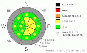
Danger Rose Tutorial
|
The danger is LOW this morning and may rise to MODERATE this afternoon with the storm. I expect a poor bond to many of the mid and upper elevation shady slopes and initially sluffing will be the primary issue. With expected sustained post frontal winds, watch for drifting in the steeper lee starting zones, most prominent in north through east through southeast facing slopes. |
|
|
CURRENT CONDITIONS |

|
Skies are mostly clear this morning with a few scattered clouds thrown in the mix. Mountain temps are at 24 hour highs and are in the mid to upper 30's above and below a thermal belt max of 40 degrees around 9000'. Winds have increased from the west to southwest, blowing 15-20mph, with the most exposed ridgelines recording hourly gusts into the 40's. All classic pre-frontal conditions in anticipation of today's cold front in the early afternoon. Saturday's rime event and graupel storm is the latest insult to our beleaguered snowpack, but, it's the only one we have, and we'll look to add a few inches of snow this afternoon and evening before the storm races on to the east. |
|
|
RECENT ACTIVITY |

|
The weekend's graupel event left some walking through a veritable sandbox in localized areas along the higher elevations and explosive work in the upper Cottonwoods on Sunday pulled out a few 1-2' deep class 2 pockets in steep uncompacted terrain. One was enough to leave 3-4' deep debris in the runout zone. |
|
|
THREAT #1 |

|
| WHERE |
PROBABILITY |
SIZE |
TREND |
|
|
|
|
| |
|
|
Over the next
24 hours.
|
|
|
It's critical to look at what we have and what we're gonna get. Our 1-2' deep snowpack (in mid and upper elevation shady terrain) is comprised of a number of facet/crust combinations above some deteriorating faceted snow. Evelyn's profile from yesterday gives a generalized idea of what we're looking at. Today's new snow is likely to sluff off many of the steeper slopes on the slick crusts and 'grease' of a thin surface hoar layer or low density snow. |
|
|
THREAT #2 |

|
| WHERE |
PROBABILITY |
SIZE |
TREND |

|
|
|
|
| |
|
|
Over the next
24 hours.
|
|
|
Drifting is likely on the steeper upper elevation slopes. What is less clear is what role the uppermost crust (from Saturday night) will play in the activity. More than likely, we won't receive enough snow for it to be a factor, but crusts can often allow the snow to accumulate prior to failure, resulting in significantly larger avalanches. We often attribute some of this thinking, locally, to Peter Lev – a long since retired UDOT forecaster. |
|
|
MOUNTAIN WEATHER |

|
We'll see increasing clouds ahead of today's cold front. Snowfall should begin in the early afternoon and continue into the evening. The northern Utah mountains may see 3-7” of snow by tonight as the fast moving storm races off into Colorado. Temps will plunge into the upper teens tonight and the veering winds, while gusty at the time of frontal passage, will start to relax tonight. Another, weaker disturbance clips northern Utah on Thursday ahead of another warming trend for the weekend. There may be some cause for optimism early next week. |
|
|
GENERAL ANNOUNCEMENTS |
We'll do intermittent updates as conditions change.
If you want to get this avalanche advisory e-mailed to you daily click HERE.
UDOT highway avalanche control work info can be found by calling (801) 975-4838. Our statewide toll free line is 1-888-999-4019 (early morning, option 8).
The UAC depends on contributions from users like you to support our work. To find out more about how you can support our efforts to continue providing the avalanche forecasting and education that you expect please visitour Friends page.
If you’re getting out and see anything we should know about please let us know. You can leave a message at (801) 524-5304 or 1-800-662-4140, or email us at uac@utahavalanchecenter.org. (Fax 801-524-6301).
The information in this advisory is from the U.S. Forest Service, which is solely responsible for its content. This advisory describes general avalanche conditions and local variations always occur. |
|
|
This information does not apply to developed ski areas or highways where avalanche control is normally done. This advisory is from the U.S.D.A. Forest Service, which is solely responsible for its content. This advisory describes general avalanche conditions and local variations always occur. |
|
This advisory provided by the USDA Forest Service, in partnership with:
The Friends of the Utah Avalanche Center, Utah Division of State Parks and Recreation, Utah Division of Emergency Management, Salt Lake County, Salt Lake Unified Fire Authority and the friends of the La Sal Avalanche Center. See our Sponsors Page for a complete list. |
