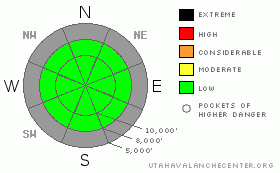
BOTTOM LINE
Danger by aspect and elevation on slopes approaching 35° or steeper.
(click HERE for tomorrow's danger rating)
|
Danger Rose Tutorial
|
What little snow exists in the Wasatch mountains is generally stable. If you're traveling in upper elevation shady terrain, a small sluff or even an old piece of shallow wind slab could be triggered on steep slopes and knock you off balance. However, hitting a rock is the more likely scenario for getting injured.
|
|
|
CURRENT CONDITIONS |

|
A cooling trend and cloud cover finally kept most mountain temperatures out of the 50's today, but they still reached into the 40's at many mid elevations. Ahead of tonight's dry cold front, winds today have shifted to a southwesterly direction, and are in the 10 - 15 mph range. Snow conditions are nothing to write home about – about 2 feet in shady upper Little Cottonwood and slightly less in Big Cottonwood and along the Park City ridge line. Upper elevation shady slopes have patches of soft, recrystallized snow, thin crusts and surface hoar that make for OK turning. However, tricky, breakable crusts are more the norm. The snow on the sunny slopes is rock hard when cold, but with enough sun softens into imitation corn. (photo)
|
|
|
RECENT ACTIVITY |

|
No avalanche activity has been reported from the backcountry or the resorts for the past couple of days.
|
|
|
THREAT #1 |

|
| WHERE |
PROBABILITY |
SIZE |
TREND |
|
|
|
|
| |
|
|
Over the next
24
hours.
|
|
|
The surface snow on the shady slopes definitely had my attention yesterday. The upper six inches has recrystallized into a layer of loose, weak snow disappointingly fast. (Snow Profile) With the current dry forecast, this recrystallization process will continue for a few more days. Currently, it's only danger is possibly producing a small sluff. However, it's role as a future weak layer will keep us on our toes. Where any snow is left on the sunny southerly and westerly aspects, the snow pack is strong when frozen. Brett Kobernik put together a nice gallery with some thoughts on our early season snowpack.
|
|
|
MOUNTAIN WEATHER |

|
A weak and generally dry cold front will cross northern Utah tonight. This will bring cooler temperatures with a trace to an inch of snow. Winds will shift to the northwest tonight, with average speeds remaining less than 15 mph across all but the highest terrain. Temperatures will drop into the teens and low 20's. Friday will be partly cloudy, with high temperatures in the lower 40's at 8,000' and the mid 30's at 10,000'. A second weak cold front will cross far northern Utah late Saturday night. Unfortunately, we have to look to at least mid week for any significant snow fall.
|
|
|
GENERAL ANNOUNCEMENTS |
We are only doing afternoon and/or intermittent avalanche advisories until winter returns or the avalanche conditions change.
If you want to get this avalanche advisory e-mailed to you daily click HERE.
UDOT highway avalanche control work info can be found by calling (801) 975-4838.
Our statewide toll free line is 1-888-999-4019 (early morning, option 8).
The UAC depends on contributions from users like you to support our work. To find out more about how you can support our efforts to continue providing the avalanche forecasting and education that you expect please visitour Friends page.
If you’re getting out and see anything we should know about please let us know. You can leave a message at (801) 524-5304 or 1-800-662-4140, or email us at uac@utahavalanchecenter.org. (Fax 801-524-6301)
This advisory will only be updated as conditions change. |
|
|
This information does not apply to developed ski areas or highways where avalanche control is normally done. This advisory is from the U.S.D.A. Forest Service, which is solely responsible for its content. This advisory describes general avalanche conditions and local variations always occur. |
|
This advisory provided by the USDA Forest Service, in partnership with:
The Friends of the Utah Avalanche Center, Utah Division of State Parks and Recreation, Utah Division of Emergency Management, Salt Lake County, Salt Lake Unified Fire Authority and the friends of the La Sal Avalanche Center. See our Sponsors Page for a complete list. |
