SPECIAL ANNOUNCEMENT |
 |
We will be going back to afternoon and/or intermittent avalanche advisories until winter returns or the avalanche conditions change.
|
|
|
BOTTOM LINE
Danger by aspect and elevation on slopes approaching 35° or steeper.
(click HERE for tomorrow's danger rating)
|
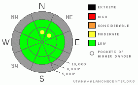
Danger Rose Tutorial
|
Bottom Line for the Ogden, Salt Lake, Park City and Provo area mountains:
While the avalanche danger is generally LOW, beware of unstable snow in isolated terrain. It may be possible to find a wind drift or two on steep upper elevation slopes that could be released by the weight of a person. Also, as the snow heats up each day, it may become possible to trigger large roller balls or a damp sluff that could knock you off your feet. As always, practice standard safe travel procedures – carry avalanche rescue gear and travel one at a time on steep slopes.
|
|
|
CURRENT CONDITIONS |

|
Under clear skies, temperatures are fairly uniform this morning - in the low to mid 20's from 7,000 to 11,000 feet. The northerly winds have been steadily diminishing over the past 24 hours, and speeds are generally less than 15 mph, with only a few ridge line stations still gusting in the 20's and 30's.
Turning and riding conditions were surprisingly good yesterday above about 9,500' with a skiff of recrystallized snow on top of cold dense supportable snow. At these higher elevations, the scattered rime and mist crusts are paper thin and easy to blast through, and there were far fewer wind drifts to trip me up than I though there would be. Below about 9,500 feet, challenging would be a kind way to describe this morning's icy snow conditions – inconsistent, supportable to breakable crusts are on all aspects, though they will become friendlier later today as they warm and soften. A mini corn cycle possible in a day or two?
|
|
|
RECENT ACTIVITY |

|
No avalanche activity was reported from the backcountry yesterday.
|
|
|
THREAT #1 |

|
| WHERE |
PROBABILITY |
SIZE |
TREND |

|
|
|
|
| |
|
|
Over the next
24
hours.
|
|
|
The combination of high winds, warm temperatures, damp snow and rain over the past few days has glued, pounded and strengthened the snow pack. Most wind drifts are stubborn and reluctant to move – however, I'm sure somewhere in the steepest, upper elevation terrain there's one or two drifts that could be triggered. So think consequences – a small slab released above a cliff or in rocky terrain could result in serious injuries. In mid elevation terrain, abundant sunshine and warming temperatures will soften the snow to the point that wet sluffs could be triggered, so avoid getting knocked off your feet. As temperatures warm over the next few days, even the upper elevation steep sunny slopes could get in on the wet sluff action.
|
|
|
MOUNTAIN WEATHER |

|
Today will be absolutely delightful in the mountains, with lots of sunshine and temperatures warming into the mid 40's at 8,000' and the mid 30's at 10,000'. Winds will continue to drop off, with speeds across even the most exposed terrain decreasing to less than 15 mph by evening. Unfortunately, a second, unwelcome Indian Summer has begun as the strong ridge of high pressure building into the area today will remain through much of the next week. Mostly clear skies tonight through Wednesday, with 8,000' highs in the low to mid 50's and lows in the 30's. 10,000' free air temperatures will peak around Monday-Tuesday, in the low 40's.
|
|
|
GENERAL ANNOUNCEMENTS |
Don't forget about Ski Utah's Fat Flake Festival is today at the Gallivan Center in downtown Salt Lake City. You can click HERE for more information.
If you want to get this avalanche advisory e-mailed to you daily click HERE.
UDOT highway avalanche control work info can be found by calling (801) 975-4838.
Our statewide toll free line is 1-888-999-4019 (early morning, option 8).
The UAC depends on contributions from users like you to support our work. To find out more about how you can support our efforts to continue providing the avalanche forecasting and education that you expect please visitour Friends page.
If you’re getting out and see anything we should know about please let us know. You can leave a message at (801) 524-5304 or 1-800-662-4140, or email us at uac@utahavalanchecenter.org. (Fax 801-524-6301).
This advisory will be updated every few days or as conditions change.
|
|
|
This information does not apply to developed ski areas or highways where avalanche control is normally done. This advisory is from the U.S.D.A. Forest Service, which is solely responsible for its content. This advisory describes general avalanche conditions and local variations always occur. |
|
This advisory provided by the USDA Forest Service, in partnership with:
The Friends of the Utah Avalanche Center, Utah Division of State Parks and Recreation, Utah Division of Emergency Management, Salt Lake County, Salt Lake Unified Fire Authority and the friends of the La Sal Avalanche Center. See our Sponsors Page for a complete list. |
