SPECIAL ANNOUNCEMENT |
 |
Unopened ski resorts must be treated as backcountry terrain. There is no avalanche control work being done nor is there ski patrol available for injuries or rescue until the resorts open for the season. You are responsible for your actions in these areas. Treat them as any other backcountry terrain. |
|
|
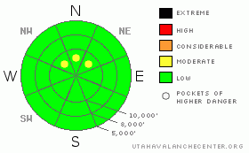
BOTTOM LINE
Danger by aspect and elevation on slopes approaching 35° or steeper.
(click HERE for tomorrow's danger rating)
|
Danger Rose Tutorial
|
The avalanche danger is generally LOW. You may find a pocket or two that could avalanche above around 10,000 feet on the northerly aspects of the upper Cottonwood Canyons. With a winter storm moving in, the avalanche danger will be on the rise but the danger probably won't increase dramatically by the end of the day unless we experience a period of more intense snowfall then is expected. |
|
|
CURRENT CONDITIONS |

|
Settlement is the first thing that comes to my mind this morning. The snow from our recent lake enhanced snow storm has settled almost 50%. (Seasonal Charts) The upper Cottonwoods have generally 2 to 3 feet of total snow depending on aspect and elevation while outlying areas in the Park City, Ogden and Provo areas have generally under a foot. (Mt Ogden-Snowbasin Photo) Warm temperatures over the last few days are a major contributor to the settlement. Many slopes became damp and rollerballs were seen on many slopes away from the higher elvation north aspects. This will produce a stout crust that will be difficult to negotiate until there's some more fresh snow. After the coldest reading last night at around 11pm temperatures are currently in the mid to upper 20s at the 9000 foot level. Winds have switched to a southerly direction and are averaging 10 to 15 mph gusting to around 30 along the higher ridges. |
|
|
RECENT ACTIVITY |

|
There was no avalanche activity reported from Saturday. (It's very early in the season and I've compiled a few early season reminders that you may want to take a look at to get you thinking snow again. Click HERE) |
|
|
THREAT #1 |

|
| WHERE |
PROBABILITY |
SIZE |
TREND |

|
|
|
|
| |
|
|
Over the next
24
hours.
|
|
|
For today, the thing I would be looking for is the condition of October's snow along the highest northerly slopes. It seems like the snowpack has settled into a fairly stable condition but we just haven't been out to a whole lot of areas yet this winter. We are looking at the snow right near the ground to see if it contains loose faceted crystals. We've found many areas where these crystals are damp and some areas where they are now frozen (Snowpit). It seems like any avalanching on this layer is unlikely but further sleuthing is mandatory as you may still find a pocket in the highest north aspects.
The few wind slabs that folks found a few days ago are more then likely a thing of the past. However, every experienced snow evaluator will test any obvious areas of wind affected snow by jumping on test slopes or doing a quick hand pit to reveal the truth. |
|
|
MOUNTAIN WEATHER |

|
A moist but not real cold winter storm will start producing snow today. Snow levels will start out around 8000 to 8500 feet and drop later today. The bulk of the storm is heading south of our area but with plenty of moisture associated we should see a few inches of snow during the day. Snowfall should intensify a bit with a cold front this evening. A moist northerly flow continues into Monday. If we're lucky we could see upwards of 10" of snow.
We'll get a little break then more moisture will move through in the continuing northwest flow through mid week before a large ridge (see below) moves in for the weekend. Currently the ridge doesn't look like it will persist long.

|
|
|
GENERAL ANNOUNCEMENTS |
Our statewide toll free line is 1-888-999-4019 (early morning, option 8).
If you’re getting out and see anything we should know about please let us know. You can leave a message at (801) 524-5304 or 1-800-662-4140, or email us at uac@utahavalanchecenter.org. (Fax 801-524-6301)
The information in this advisory is from the U.S. Forest Service, which is solely responsible for its content. This advisory describes general avalanche conditions and local variations always occur.
Bruce Tremper will update this forecast tomorrow, and thanks for calling. |
|
|
This information does not apply to developed ski areas or highways where avalanche control is normally done. This advisory is from the U.S.D.A. Forest Service, which is solely responsible for its content. This advisory describes general avalanche conditions and local variations always occur. |
|
This advisory provided by the USDA Forest Service, in partnership with:
The Friends of the Utah Avalanche Center, Utah Division of State Parks and Recreation, Utah Division of Emergency Management, Salt Lake County, Salt Lake Unified Fire Authority and the friends of the La Sal Avalanche Center. See our Sponsors Page for a complete list. |
