25th Annual Black Diamond Fall Fundraising Party
Thursday, September 13; 6:00-10:00 PM; Black Diamond Parking Lot
25th Annual Black Diamond Fall Fundraising Party
Thursday, September 13; 6:00-10:00 PM; Black Diamond Parking Lot
| Advisory: Uintas Area Mountains | Issued by Craig Gordon for Friday - April 6, 2018 - 3:01am |
|---|

|
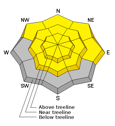
bottom line Initially starting as LOW, the danger of wet avalanches increases to MODERATE and human triggered slides and sluffs are possible as the day heats up. In addition, a MODERATE danger exists on steep wind drifted slopes at and above treeline, where a very isolated chance of triggering an unpredictably large avalanche still exists. The usual suspects include- steep, rocky terrain facing the north half of the compass, especially slopes with a thin, weak snowpack. Deep, dangerous, human triggered avalanches are POSSIBLE in terrain with these kind of characteristics.
|
 |
special announcement This Sunday April 8th will be the last of the regularly scheduled advisories for the western Uinta Mountains. |
 |
current conditions A moist and mild westerly flow delivered an inch of damp snow yesterday. This morning under a blanket of thickening clouds, overnight temperatures remained mild, hovering right around freezing. Southwest winds increased around 10:00 last night, blowing steadily in the 20's and 30's along the high ridges. Riding and turning conditions are hit or miss, but in between frozen tracks and swaths of sage and asphalt, a few patches of soft settled snow are found on sheltered, shady slopes.
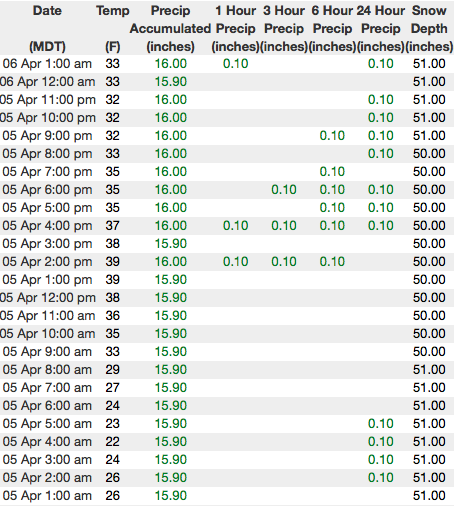
Above are 24 hour temperatures and snow depth in Chalk Creek along with winds and temperatures from Windy Peak. More remote Uinta weather stations are found here
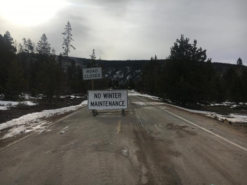
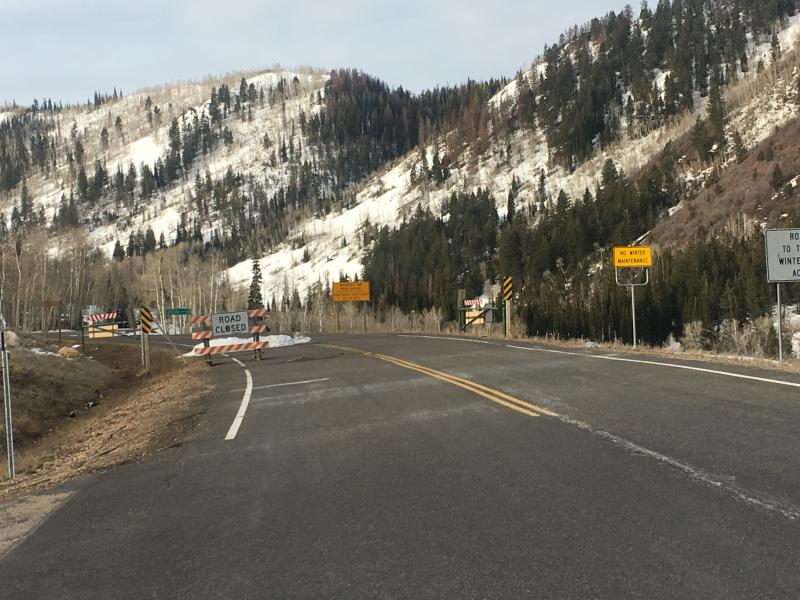
Well this is a heck of a way to run a winter. Pictured above... a tale of two trailheads. Common theme... while still closed, they're both toast and dry for miles. A great body of recent trip reports, observations, and snow data here. |
 |
recent activity No significant avalanche activity to report from yesterday. A full list of avalanches is found here. |
| type | aspect/elevation | characteristics |
|---|

|
|
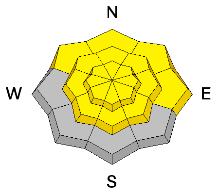
LIKELIHOOD
 LIKELY
UNLIKELY
SIZE
 LARGE
SMALL
TREND
 INCREASING DANGER
SAME
DECREASING DANGER
|
|
description
With mild temperatures in place along with rain and snow in the forecast, the danger for wet slides and sluffs increases throughout the day, especially if the sun peeks through the clouds. As always, if the snow you're riding on becomes damp and manky or the bottom starts falling out, it's time to either change aspect and elevation, or simply call it a day. |
| type | aspect/elevation | characteristics |
|---|

|
|
LIKELIHOOD
 LIKELY
UNLIKELY
SIZE
 LARGE
SMALL
TREND
INCREASING DANGER
SAME
DECREASING DANGER
|
|
description
We haven't heard of any avalanche activity breaking to deeply buried weak layers for over a week now and that's good news. Of course, Monday nights cold snap helped weld the snowpack in place. Where the pack is deep, it's happy in its own skin. For the most part, I think these instabilities have gone dormant for the moment. However, I'm not ready to let my guard down where the pack has remained thin and weak all year. Prime suspects include steep, rocky, upper elevation terrain facing the north half of the compass, along with slopes that already avalanched this season. |
 |
weather A warm, wet system is churning along the coast and has its sights on Utah, arriving Saturday. In the mean-time, today we can expect cloudy skies with a few scattered rain and snow showers on tap. High temperatures climb into the 40's and southwest winds blow in the 30's along the high ridges. Moisture surges into the area Saturday. Initially beginning as rain, colder air filters in towards the afternoon, though may be a little late to the party to produce big snow totals. |
| general announcements The information in this advisory expires 24 hours after the date and time posted, but will be updated by 7:00 AM Saturday April 7th, 2018. If you're getting out and about, please let me know what you're seeing especially if you see or trigger and avalanche. I can be reached at [email protected] or 801-231-2170 It's also a good time to set up one of our very popular avalanche awareness classes. Reach out to me and I'll make it happen. This information does not apply to developed ski areas or highways where avalanche control is normally done. This advisory is from the U.S.D.A. Forest Service, which is solely responsible for its content. This advisory describes general avalanche conditions and local variations always occur. |