25th Annual Black Diamond Fall Fundraising Party
Thursday, September 13; 6:00-10:00 PM; Black Diamond Parking Lot
25th Annual Black Diamond Fall Fundraising Party
Thursday, September 13; 6:00-10:00 PM; Black Diamond Parking Lot
| Advisory: Uintas Area Mountains | Issued by Craig Gordon for Tuesday - April 3, 2018 - 3:00am |
|---|


|
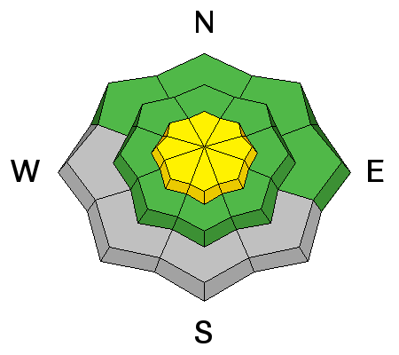
bottom line In a sea of generally LOW avalanche danger, a MODERATE danger exists on steep wind drifted slopes at and above treeline and human triggered avalanches are POSSIBLE. In addition, a very isolated chance of triggering a deep, dangerous avalanche still exists. The usual suspects include- steep, rocky terrain facing the north half of the compass, especially slopes with a thin, weak snowpack. Human triggered avalanches are POSSIBLE in terrain with these kind of characteristics.
|
 |
special announcement This Sunday April 8th will be the last of the regularly scheduled advisories for the western Uinta Mountains. |
 |
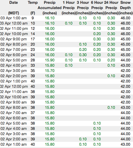
current conditions Yesterday's fast moving cold front delivered 3"-5" of snow across the north half of the range, with half that amount falling from Noblett's to Daniels. Skies are clear and it's cold with temperatures registering in the single digits. West and northwest winds blow in the 20's along the high ridges. Riding and turning conditions are aspect dependant. South facing slopes offer smooth, suportable, corn-like conditions that, with strong springtime sun, will soften later today. Whilst on the other half of the compass, shallow, soft snow is found on upper elevation wind sheltered, shady slopes.
Above are 24 hour temperatures and snow depth in Chalk Creek along with winds and temperatures from Windy Peak. More remote Uinta weather stations are found here A great body of recent trip reports, observations, and snow data here. |
 |
recent activity
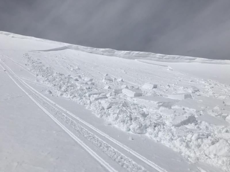
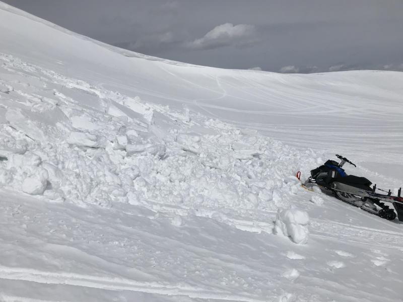
This slide triggered Sunday in Timberlakes knocked the legs out from under a large piece of corni, which then released a fresh slab on a heavily wind drifted, east facing slope. Certainly big enough to roll a rider. Thanks Jess for the info! A full list of recent avalanches is found here. |
| type | aspect/elevation | characteristics |
|---|

|
|
LIKELIHOOD
 LIKELY
UNLIKELY
SIZE
 LARGE
SMALL
TREND
 INCREASING DANGER
SAME
DECREASING DANGER
|
|
description
Winds have a little new snow to work with and fresh drifts, sensitive to our additional weight are today's most obvious and manageable avalanche problem. Predictably breaking at or below our skis, board or sled, today's shallow slabs are easy to detect and easy to avoid. Lose a little elevation and you lose the problem. Or simply steer clear of fat, rounded pieces of snow, especially if they feel or sound hollow like a drum. |
| type | aspect/elevation | characteristics |
|---|

|
|
LIKELIHOOD
 LIKELY
UNLIKELY
SIZE
 LARGE
SMALL
TREND
 INCREASING DANGER
SAME
DECREASING DANGER
|
|
description
We haven't heard of any avalanche activity breaking to deeply buried weak layers for over a week now and that's good news. Of course, last nights cold snap helped weld the snowpack in place. Where the pack is deep, it's happy in its own skin. For the most part, I think these instabilities have gone dormant for the moment. However, I'm not ready to let my guard down where the pack has remained thin and weak all year. Prime suspects include steep, rocky, upper elevation terrain facing the north half of the compass, along with slopes that already avalanched this season. |
 |
weather Today, look for clear skies, light winds, and cold temperatures with highs only reaching into the mid 20's. Clouds increase this evening ahead of a series of relatively weak but increasingly moist disturbances that cross the area through the end of the week and into the weekend. |
| general announcements The information in this advisory expires 24 hours after the date and time posted, but will be updated by 7:00 AM Wednesday April 4th, 2018. If you're getting out and about, please let me know what you're seeing especially if you see or trigger and avalanche. I can be reached at [email protected] or 801-231-2170 It's also a good time to set up one of our very popular avalanche awareness classes. Reach out to me and I'll make it happen. This information does not apply to developed ski areas or highways where avalanche control is normally done. This advisory is from the U.S.D.A. Forest Service, which is solely responsible for its content. This advisory describes general avalanche conditions and local variations always occur. |