25th Annual Black Diamond Fall Fundraising Party
Thursday, September 13; 6:00-10:00 PM; Black Diamond Parking Lot
25th Annual Black Diamond Fall Fundraising Party
Thursday, September 13; 6:00-10:00 PM; Black Diamond Parking Lot
| Advisory: Uintas Area Mountains | Issued by Craig Gordon for Wednesday - March 28, 2018 - 4:01am |
|---|

|
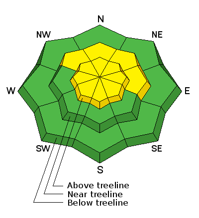
bottom line A MODERATE avalanche danger exists in mid and upper elevation terrain, particularly in the wind zone, above treeline. Deep and dangerous, human triggered dry snow avalanches are POSSIBLE on all steep wind drifted slopes, especially those facing the north half of the compass, and particularly those with an easterly component to their aspect. LOW avalanche danger is found on most south facing terrain and wind sheltered slopes.
|
 |
special announcement We couldn't get out on the snow without the great support from Polaris, Ski Doo, and Arctic Cat as well as KTM and Timbersled. Our local dealers make it happen. Tri-City Performance, Weller Recreation, Northstar's Ultimate Outdoors, Big Pine and Morgan Valley Polaris. We use these machines to monitor the snowpack across the state of Utah. We also use these machines to teach life-saving classes. |
 |
current conditions Clouds increased overnight and a few snow flurries are in the air this morning. West and northwest winds blow 20-30 mph along the high ridges and temperatures are in the teens and mid 20's. Riding and turning conditions are exceptionally good, especially on wind sheltered, shady slopes.
Above are 24 hour temperatures and snow depth near Trial Lake along with winds and temperatures from Windy Peak. More remote Uinta weather stations are found here A great body of recent trip reports, observations, and snow data here. |
 |
recent activity No new avy activity since Saturday, but it was quite active towards the end of last week.
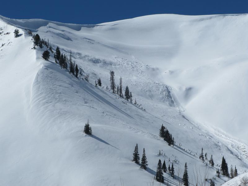
Saturday on Double Hill, a man riding with his family triggered a wind slab which then pulled out a deeper avalanche that broke to the ground. He was able to get off the moving piece of snow, but the debris ran farther than expected, coming within 5 feet of where his son was parked. A very close call indeed and this was a bullet dodged that fortunately, had a happy ending.
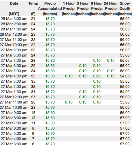
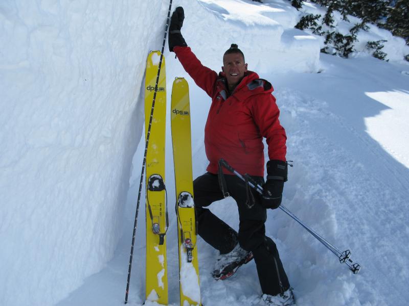
This slide monster slide was triggered Friday in Upper Moffit Basin, from a piece of cornice near the ridge dropping onto the slope below. Breaking deep, wide, and failing on faceted snow near a buried early season crust, this avalanche was certainly unsurvivable. More details along with a full list of recent avalanches is found here. |
| type | aspect/elevation | characteristics |
|---|

|
|
LIKELIHOOD
 LIKELY
UNLIKELY
SIZE
 LARGE
SMALL
TREND
 INCREASING DANGER
SAME
DECREASING DANGER
|
|
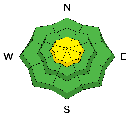
description
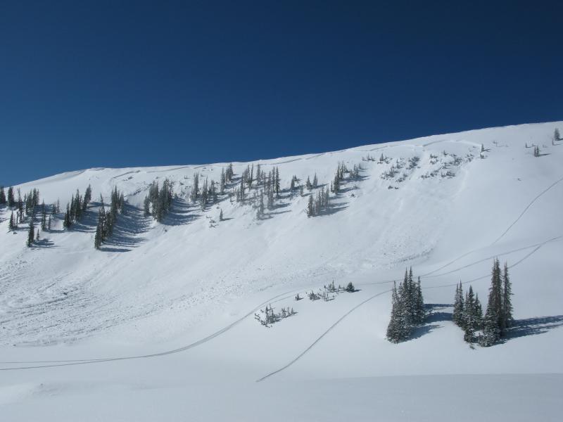
A few fresh drifts, like the one pictured above, developed overnight. Mostly prominent on the leeward side of upper elevation ridges, there might be a cross-loaded pocket around a terrain feature like a chute or gully wall. In any case, today you'll want to look for and avoid fat, rounded pieces of snow, especially if they sound and feel hollow like a drum. Once triggered, today's wind slabs have the potential to break deeper and wider than you might expect. |
| type | aspect/elevation | characteristics |
|---|

|
|
LIKELIHOOD
LIKELY
UNLIKELY
SIZE
 LARGE
SMALL
TREND
INCREASING DANGER
SAME
DECREASING DANGER
|
|
description
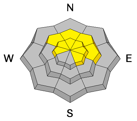
Deep slabs- They're tricky, they're dangerous, they're unpredictable, and now this notoriously deceptive avalanche dragon came alive late last week on the eastern front. The good news is... the weekend cold snap welded the snowpack in place and most of these instabilities appear to be dormant for the moment. The bad news is... our usual observations regarding snow stability often give misleading, green light feedback. That means tracks on the slope, cornice drops, or slope cuts are unreliable methods of testing the slope. In fact, this strong, cohesive slab often allows us to get well out onto the slope before it fails and now the snow is breaking to the ground taking out the entire seasons snowpack. So how do you manage an unmanageable avalanche problem? Well... we simply avoid it. Steep, mid and upper elevation terrain facing the north half of the compass are prime suspects as are slopes that already avalanched this season, and terrain that has remained thin all year. So here's the exit strategy... if you're looking for soft snow and safe riding, simply tone down your slope angles and avoid terrain with steep slopes hanging above you.
The natural slide in the images above broke to the dirt early Friday morning and stacked up a huge piles of body snapping debris... unsurviveable if you were on the receiving end. |
 |
weather Cloudy skies and light snow showers linger over the region this morning. High temperatures reach into the low 30's and overnight lows dip into the 20's. West winds blow 15-30 mph along the ridges. High pressure builds for the remainder of the work week. |
| general announcements The information in this advisory expires 24 hours after the date and time posted, but will be updated by 7:00 AM Thursday March 29th, 2018. If you're getting out and about, please let me know what you're seeing especially if you see or trigger and avalanche. I can be reached at [email protected] or 801-231-2170 It's also a good time to set up one of our very popular avalanche awareness classes. Reach out to me and I'll make it happen. This information does not apply to developed ski areas or highways where avalanche control is normally done. This advisory is from the U.S.D.A. Forest Service, which is solely responsible for its content. This advisory describes general avalanche conditions and local variations always occur. |