25th Annual Black Diamond Fall Fundraising Party
Thursday, September 13; 6:00-10:00 PM; Black Diamond Parking Lot
25th Annual Black Diamond Fall Fundraising Party
Thursday, September 13; 6:00-10:00 PM; Black Diamond Parking Lot
| Advisory: Uintas Area Mountains | Issued by Craig Gordon for Friday - March 23, 2018 - 3:18am |
|---|

|
bottom line HEADS UP- THIS IS AN UNUSUALLY WARM, WET STORM AND WE'RE NAVIGATING SOME UNCHARTED WATERS. BUT WHAT I DO KNOW IS THIS... THE AVALANCHE DANGER IS OUT OF THE ORDINARY. A CONSIDERABLE avalanche danger exists in upper elevation terrain, particularly in the wind zone, above treeline. Human triggered dry snow avalanches are LIKELY on all steep wind drifted slopes, especially those facing the north half of the compass, and particularly those with an easterly component to their aspect. At mid and lower elevations, the danger for wet avalanches is CONSIDERABLE. Both human and naturally triggered slides and wet sluffs are LIKELY on slopes steeper than about 35 degrees.
|
 |
special announcement We couldn't get out on the snow without the great support from Polaris, Ski Doo, and Arctic Cat as well as KTM and Timbersled. Our local dealers make it happen. Tri-City Performance, Weller Recreation, Northstar's Ultimate Outdoors, Big Pine and Morgan Valley Polaris. We use these machines to monitor the snowpack across the state of Utah. We also use these machines to teach life-saving classes. |
 |
current conditions Round one of the big storm delivered a combination of low elevation rain and a couple inches of damp, glop in mid and upper elevation terrain. Round two of the storm is just mateializing and the cold air barely arrived, knocking temperatures into the mid 20's and low 30's. South and southeast winds are ripping into the 40's and 50's with gusts in the 70's along the high peaks. Riding and turning conditions are all over the place, and you might wanna get some projects done today or at least wait for snow to stack up for a while and consider a dusk patrol.
Above are 24 hour temperatures and snow depth near Trial Lake along with winds and temperatures from Lofty Lake Peak. More remote Uinta weather stations are found here A great body of recent trip reports, observations, and snow data here. |
 |
recent activity
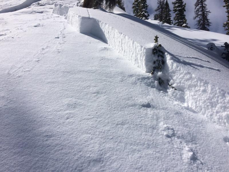
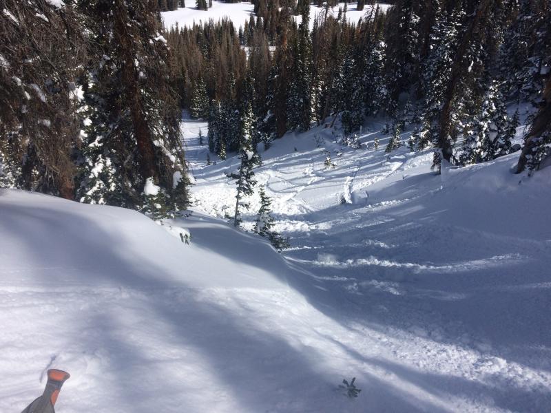
No avalanche activity reported Thursday, but Chris Brown was in Upper Whitney Basin Wednesday and snapped these images of an intentionally triggered storm slab, breaking 18" deep, and failing on facets above a thin rime crust on a steep, north facing slope. More details along with a full list of recent avalanches is found here. |
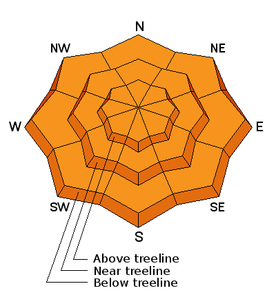
| type | aspect/elevation | characteristics |
|---|

|

|
LIKELIHOOD
 LIKELY
UNLIKELY
SIZE
 LARGE
SMALL
TREND
 INCREASING DANGER
SAME
DECREASING DANGER
|
|
description
Winds are cranking and now they have some snow to work with. As the next shot of snow kicks in and drifting becomes more widespread, I suspect shallow slabs will quickly grow on the leeward side of upper elevation ridges. Due to the winds' strength, drifts have formed lower downslope and there's cross-loaded pockets around terrain features like chutes and gullies. In any case, today you'll want to look for and avoid fat, rounded pieces of snow, especially if they sound and feel hollow like a drum. I think todays wind slabs are gonna be connected and more sensitive to our additional weight and that means they'll pack a punch and will easily boss you around once triggered. |
| type | aspect/elevation | characteristics |
|---|

|

|
LIKELIHOOD
LIKELY
UNLIKELY
SIZE
LARGE
SMALL
TREND
INCREASING DANGER
SAME
DECREASING DANGER
|
|
description
Here's what I know about the persistent weakness issue in our snowpack. First- every significant storm that's rolled through the region this season has reactivated our dormant weak layers, especially where the pack remains thin and weak. I think of terrain that has either avalanched this winter or zones that are shallow like the south half of the range from about Soapstone to Daniels/Strawberry area. Second- not every steep slope we ride with these characteristics is gonna avalanche and that gives us a false sense of snow stability. Third and most important- slopes with these characteristics may be reactive to our additional weight and have the possibility to break deeper and wider than you might expect. So... a bit to digest, but when I'm uncertain about sketchy avalanche dragons, I simply avoid where they live. Steep, mid and upper elevation terrain facing the north half of the compass are prime suspects as are slopes that already avalanched this season. So here's the exit strategy... if you're looking for soft snow and safe riding, simply tone down your slope angles and avoid terrain with steep slopes hanging above you. |
| type | aspect/elevation | characteristics |
|---|

|
|
LIKELIHOOD
LIKELY
UNLIKELY
SIZE
 LARGE
SMALL
TREND
 INCREASING DANGER
SAME
DECREASING DANGER
|
|
description
With another marginal overnight refreeze and now very damp snow now adding an insulating layer to the old snow surface, I suspect wet avalanches have come to life. If the snow your traveling on is damp and manky or the base your riding on has a trapdoor feeling, it's time to get off of and out from under steep slopes or simply call it a day. |
 |
weather
|
| general announcements The information in this advisory expires 24 hours after the date and time posted, but will be updated by 7:00 AM Saturday March 24th, 2018. If you're getting out and about, please let me know what you're seeing especially if you see or trigger and avalanche. I can be reached at [email protected] or 801-231-2170 It's also a good time to set up one of our very popular avalanche awareness classes. Reach out to me and I'll make it happen. This information does not apply to developed ski areas or highways where avalanche control is normally done. This advisory is from the U.S.D.A. Forest Service, which is solely responsible for its content. This advisory describes general avalanche conditions and local variations always occur. |