25th Annual Black Diamond Fall Fundraising Party
Thursday, September 13; 6:00-10:00 PM; Black Diamond Parking Lot
25th Annual Black Diamond Fall Fundraising Party
Thursday, September 13; 6:00-10:00 PM; Black Diamond Parking Lot
| Advisory: Uintas Area Mountains | Issued by Craig Gordon for Tuesday - March 20, 2018 - 3:00am |
|---|


|
bottom line A MODERATE avalanche danger exists in mid and upper elevation terrain, particularly in the wind zone, above treeline. Human triggered dry snow avalanches are POSSIBLE on all steep wind drifted slopes, especially those facing the north half of the compass, and particularly those with an easterly component to their aspect. In addition, the danger of wet slides and sluffs increases to MODERATE danger on all steep, sun baked slopes at all elevations. Human triggered wet avalanches are POSSIBLE as the day heats up. In either case- an avalanche triggered today can quickly get out of hand if it breaks into weak layers of snow, now buried deeper in our snowpack.
|
 |
special announcement We couldn't get out on the snow without the great support from Polaris, Ski Doo, and Arctic Cat as well as KTM and Timbersled. Our local dealers make it happen. Tri-City Performance, Weller Recreation, Northstar's Ultimate Outdoors, Big Pine and Morgan Valley Polaris. We use these machines to monitor the snowpack across the state of Utah. We also use these machines to teach life-saving classes. |
 |
current conditions Spring has sprung! Under clear skies, temperatures are in the single digits and low teens. Winds are light and northwesterly, blowing less than 20's mph. Yesterday's strong sun had its way with south facing terrain and sunny slopes will be crusted. On the other side of the compass the snow is cold and light and you'll encounter some of the best riding conditions all year on wind sheltered, shady slopes.
Above are 24 hour temperatures and snow depth near Trial Lake along with winds and temperatures from Currant Creek Peak. More remote Uinta weather stations are found here
Mark was in the Mirror Lake environs Sunday and found soft, creamy snow in wind sheltered terrain. More on his travels along with a great body of recent trip reports, observations, and snow data here. |
 |
recent activity
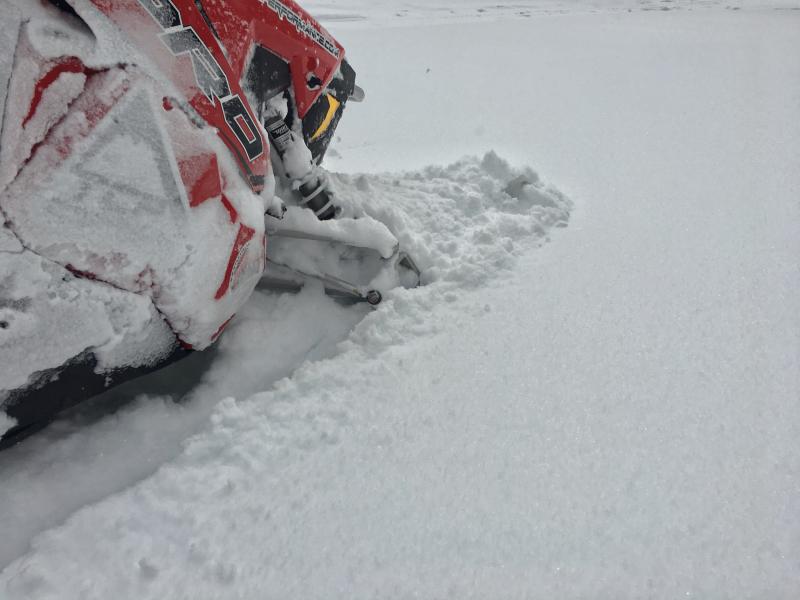
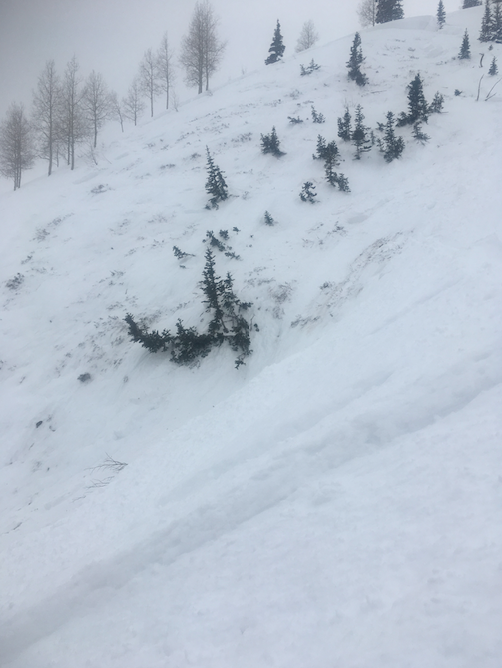
The avalanche from Sunday in the image above was triggered "remotely" or from a distance on a steep, northeast facing slope in Weber Canyon at about 9,400' in elevation. While pockety and only breaking about 50' wide, the slide broke 2'-4' deep, failing on weak snow close to the ground. Definitely a heads up that our weak snow zones are coming back to life. A list of recent avalanches is found here. |
| type | aspect/elevation | characteristics |
|---|

|
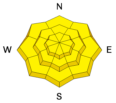
|
LIKELIHOOD
 LIKELY
UNLIKELY
SIZE
 LARGE
SMALL
TREND
 INCREASING DANGER
SAME
DECREASING DANGER
|
|
description
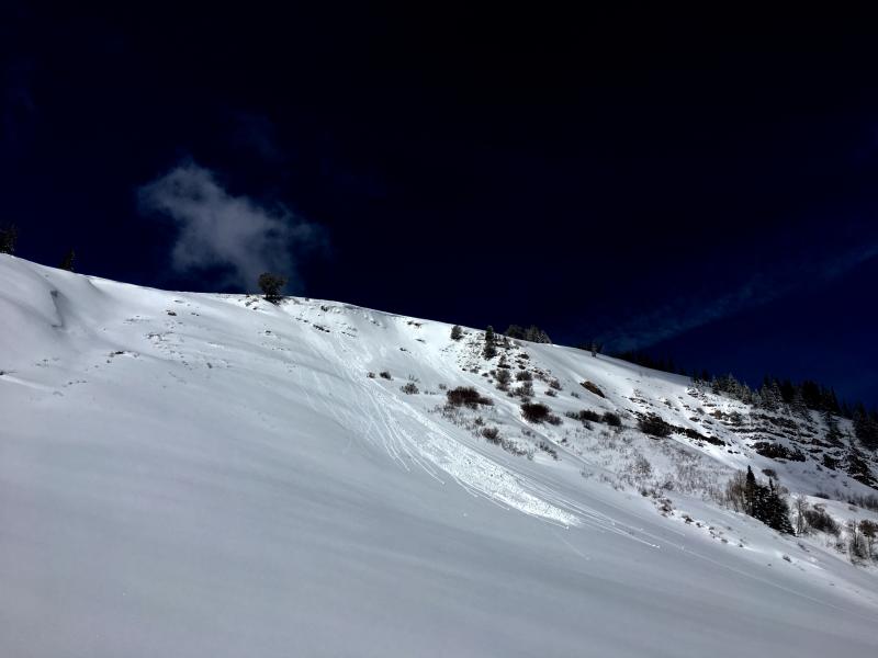
The sun is high in the sky and it's penetrating all slopes at all elevations. This means that when you're feeling like an ant under a microscope, so is the snowpack. Your best strategy is to stay one step ahead of heating and simply change aspect before the snow turns damp and manky. As the sun pounds down, simply get off of and out from under steep sunbaked slopes. Remember- wet avalanches are slow moving, but can stack up deep piles of bone twisting debris. |
| type | aspect/elevation | characteristics |
|---|

|
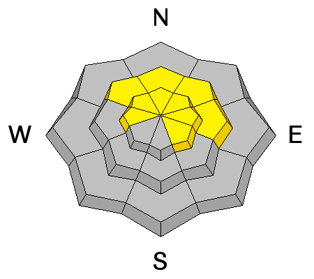
|
LIKELIHOOD
 LIKELY
UNLIKELY
SIZE
 LARGE
SMALL
TREND
 INCREASING DANGER
SAME
DECREASING DANGER
|
|
description
Now for the tricky avalanche problem- the persitent slab and buried weaknesses in the mid and lower portions of the snowpack. The good news is... the big weekend storm wasn't a big wallop of snow or water weight and I think most slopes, particularly where the snowpack is thick, are comfortable in their own skin. The bad news is.... every significant storm that's rolled through the region this season has reactivated our dormant weak layers, especially where the pack remains thin and weak. Additonal bad news alert... in many places we now have an upside down cake or strong snow, resting on top of a weak snow structure. So that's how we make the sausage. However, I bet you wanna know how to avoid triggering a deep, scary avalanche today. Well, when I'm uncertain about sketchy avalanche dragons, I simply avoid where they live. Steep, mid and upper elevation terrain facing the north half of the compass are prime suspects as are slopes that already avalanched this season. So here's the exit strategy... if you're looking for soft snow and safe riding, simply tone down your slope angles and avoid terrain with steep slopes hanging above you.
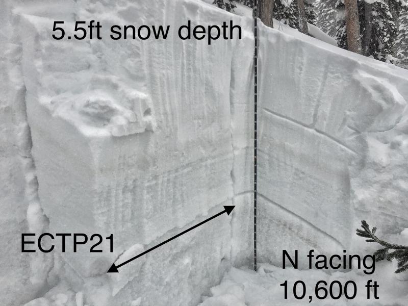
ECT - Extended column test P - means it propagated a crack across the whole column, a bad sign 21 - It took 21 taps for it to happen. The number of taps is far far less important compared to whether it propagated a crack or not. |
 |
weather
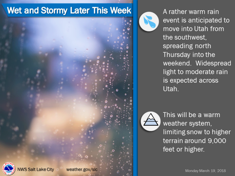
High pressure remains in place for a couple days giving us partly cloudy skies, temperatures warming into the low 30's, and light northwesterly winds. Increasing southwest flow draws a warmer and increasingly moist airmass into the area for the middle to latter part of the week. |
| general announcements The information in this advisory expires 24 hours after the date and time posted, but will be updated by 7:00 AM Wednesday March 21st, 2018. If you're getting out and about, please let me know what you're seeing especially if you see or trigger and avalanche. I can be reached at [email protected] or 801-231-2170 It's also a good time to set up one of our very popular avalanche awareness classes. Reach out to me and I'll make it happen. This information does not apply to developed ski areas or highways where avalanche control is normally done. This advisory is from the U.S.D.A. Forest Service, which is solely responsible for its content. This advisory describes general avalanche conditions and local variations always occur. |