25th Annual Black Diamond Fall Fundraising Party
Thursday, September 13; 6:00-10:00 PM; Black Diamond Parking Lot
25th Annual Black Diamond Fall Fundraising Party
Thursday, September 13; 6:00-10:00 PM; Black Diamond Parking Lot
| Advisory: Uintas Area Mountains | Issued by Craig Gordon for Sunday - March 18, 2018 - 4:03am |
|---|

|
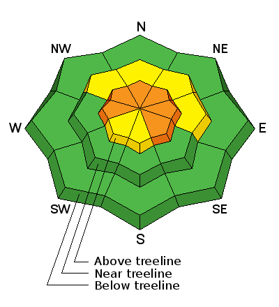
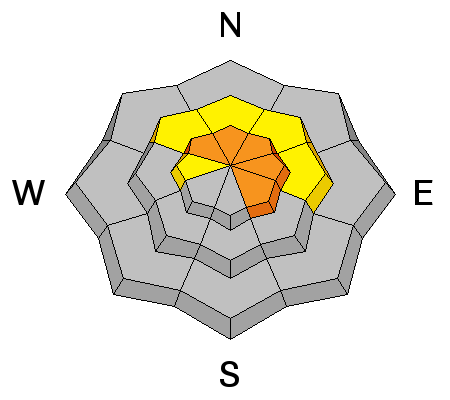
bottom line While not widespread and limited to a small portion of the terrain available to ride today, a CONSIDERABLE avalanche danger exists in upper elevation terrain in the wind zone, above treeline. Human triggered avalanches are LIKELY on all steep wind drifted slopes, especially those facing the north half of the compass, and particularly those with an easterly component to their aspect. A MODERATE avalanche danger is found on steep wind drifted slopes in mid elevation terrain and human triggered avalanches are POSSIBLE. In either case- an avalanche triggered today can quickly get out of hand if it breaks into weak layers of snow, now buried deeper in our snowpack. Lower elevation, wind sheltered terrain and most slopes facing the south half of the compass offer LOW avalanche danger.
|
 |
special announcement We couldn't get out on the snow without the great support from Polaris, Ski Doo, and Arctic Cat as well as KTM and Timbersled. Our local dealers make it happen. Tri-City Performance, Weller Recreation, Northstar's Ultimate Outdoors, Big Pine and Morgan Valley Polaris. We use these machines to monitor the snowpack across the state of Utah. We also use these machines to teach life-saving classes. |
 |
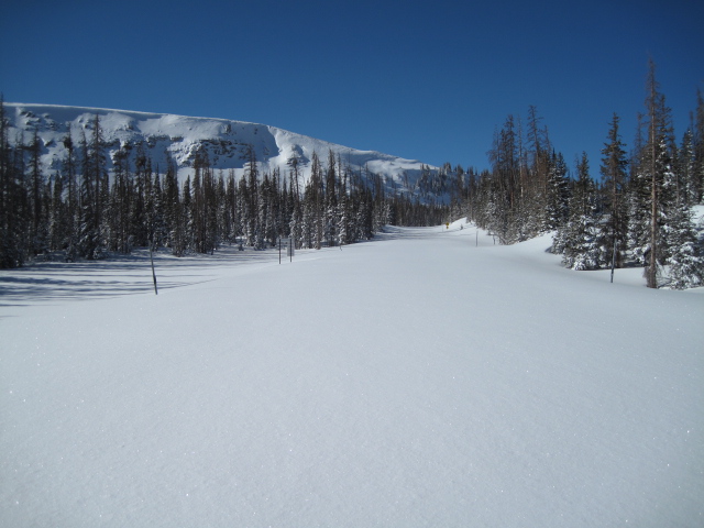
current conditions A good shot o' snow materialized for the eastern front and yesterday's storm stacked up close to a foot of chin tickling, in your grill, low density snow. Cold air arrived right around midnight, dropping temperatures into the teens and single digits. Winds shifted early this morning as well and currently blow out of the northeast, 10-20 mph along the high ridges. Yesterday's strong southerly winds damaged big, open, upper elevation terrain. However, lose a little elevation and head to wind sheltered slopes and you'll be rewarded with soft, surfy snow.
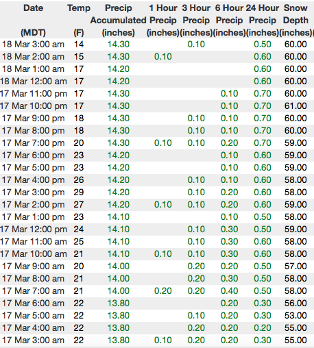
Above are 24 hour temperatures and snow depth near Trial Lake along with winds and temperatures from Windy Peak. More remote Uinta weather stations are found here
Ted was near Bald Mountain Friday and found great riding, stable snow, and miles of clean, white slate. More on his travels along with a great body of recent trip reports, observations, and snow data here. |
 |
recent activity Only one significant slide reported yesterday and it's a repeater in Weber Canyon. Releasing on a steep, rocky, upper elevation, northeast facing slope, this natural avalanche broke about a foot deep and 75' wide, but ran 500' vertically and could've easily taken you for an unexpected, body bruising ride, A list of recent avalanches is found here. |
| type | aspect/elevation | characteristics |
|---|

|
|
LIKELIHOOD
 LIKELY
UNLIKELY
SIZE
 LARGE
SMALL
TREND
 INCREASING DANGER
SAME
DECREASING DANGER
|
|
description
Southerly winds cranked yesterday, blowing in the 40's and 50's, gusting into the 70's along the high ridges. Winds had plenty of light density snow to work with and I think fresh drifts formed in unusual locations. While mainly found on the leeward side of mid and upper elevation ridgelines, I wouldn't be too surprised to find a fat drift cross-loaded in a gully or at the entrance to a chute. In any case, I bet newly formed drifts are going to be sensitive to the additional weight of a rider. While predictably breaking at or below our skis, board, or sled, today's drifts may pack a little more punch than you expect and they'll be big enough to boss you around. You can easily avoid this avalanche problem by simply steering clear of fat, rounded pillows of snow, especailly of they feel or sound hollow like a drum. |
| type | aspect/elevation | characteristics |
|---|

|
|
LIKELIHOOD
 LIKELY
UNLIKELY
SIZE
 LARGE
SMALL
TREND
 INCREASING DANGER
SAME
DECREASING DANGER
|
|
description
Now for the tricky avalanche problem- the persitent slab and buried weaknesses in the mid and lower portions of the snowpack. The good news is... yesterday's storm wasn't a big wallop of snow or water weight and I think most slopes, particularly where the snowpack is thick, are comfortable in their own skin. The bad news is.... every significant storm that's rolled through the region this season has reactivated our dormant weak layers, especially where the pack remains thin and weak. Additonal bad news alert... yesterday's winds were a game changer, creating a strong slab on top of this unpredictable snow structure. So that's how we make the sausage. However, I bet you wanna know how to avoid triggering a deep, scary avalanche today. Well, when I'm uncertain about sketchy avalanche dragons, I simply avoid where they live. Steep, mid and upper elevation terrain facing the north half of the compass are prime suspects as are slopes that already avalanched this season. So here's the exit strategy... if you're looking for soft snow and safe riding, simply tone down your slope angles and avoid terrain with steep slopes hanging above you. |
 |
weather Today we can expect mostly cloudy skies with a few light snow showers. Northerly winds blow in the 20's along the high ridges. Temperatures climb into the low 20's with overnight lows in the teens. High pressure slowly builds across the region through the first half of the week bringing a warming trend and partly cloudy skies. |
| general announcements The information in this advisory expires 24 hours after the date and time posted, but will be updated by 7:00 AM Monday March 19th, 2018. If you're getting out and about, please let me know what you're seeing especially if you see or trigger and avalanche. I can be reached at [email protected] or 801-231-2170 It's also a good time to set up one of our very popular avalanche awareness classes. Reach out to me and I'll make it happen. This information does not apply to developed ski areas or highways where avalanche control is normally done. This advisory is from the U.S.D.A. Forest Service, which is solely responsible for its content. This advisory describes general avalanche conditions and local variations always occur. |