25th Annual Black Diamond Fall Fundraising Party
Thursday, September 13; 6:00-10:00 PM; Black Diamond Parking Lot
25th Annual Black Diamond Fall Fundraising Party
Thursday, September 13; 6:00-10:00 PM; Black Diamond Parking Lot
| Advisory: Uintas Area Mountains | Issued by Craig Gordon for Tuesday - March 13, 2018 - 3:15am |
|---|

|
bottom line On steep slopes facing northwest through southeast, particularly at mid and upper elevations, the avalanche danger is MODERATE and human triggered, dry snow avalanches are POSSIBLE. Any avalanche breaking into weak layers of snow, now buried deeper in our snowpack will quickly ruin your day. The danger for wet avalanches increases to MODERATE on all steep slopes around the compass as the day wares on.
|
 |
current conditions Skies are clear and temperatures mild, in the mid to upper 20's. Southwest winds are light and in the teens and 20's along the high ridges. Riding and turning conditions are a mixed bag. Sunny slopes are crusted and will soften rapidly today. While on the other side of the compass, soft settled snow is a dwindling commodity, but still found on wind sheltered, shady slopes.
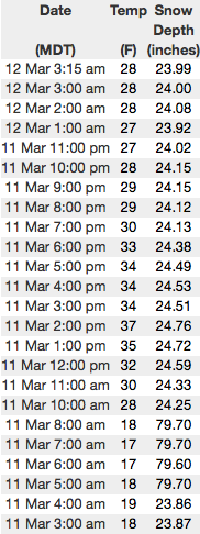
Above are 24 hour temperatures and snow depth near Currant Creek along with winds and temperatures from Windy Peak. More remote Uinta weather stations are found here
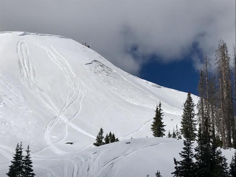
Upper elevation terrain still harbors soft snow. Andy and Bo were near Currant Creek yesterday and posted a great trip report found here. (Nassetta image) You can find a great body of recent trip reports, observations, and snow data here.
|
 |
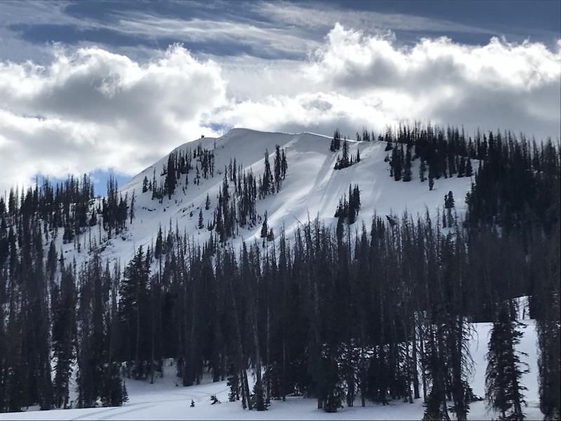
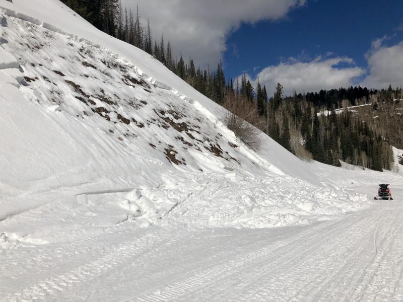
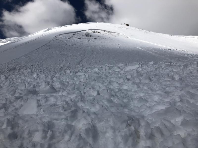
recent activity Heads up.... this is the type of avalanche we're dealing with today.
Two recent sled triggered avalanches on the south half of the range. Upper image is a northeast facing slope at about 8,200' near the Mill Hollow Trailhead. Bottom Image is a southeast facing slope near Currant Creek Peak at 10,400' in elevation. Common theme is both slides were a couple feet deep and broke close to the ground on weak, faceted snow. A list of recent avalanches is found here. |
| type | aspect/elevation | characteristics |
|---|

|

|
LIKELIHOOD
 LIKELY
UNLIKELY
SIZE
 LARGE
SMALL
TREND
 INCREASING DANGER
SAME
DECREASING DANGER
|
|
description
Our recent string of warm weather is adding another layer of complexity, helping to activate dormant weak layers of snow buried near the ground. Making the pattern unpredictable and giving us a false sense of stable snow is... not every slope is gonna be reactive to our additional weight. However, those that are, have the possibility to break deeper and wider than you might expect. So, just when you're feeling good about stability... bam, you collapse the slope and now you're staring down the barrel of a scary slide. These are the classic characteristics of an unpredictable, presistent slab. And the way we manage unpredictable avalanche dragons in the mountains is to simply avoid where they live. If you're looking for soft snow and safe riding, simply tone down your slope angles and avoid terrian with steep slopes hanging above you. |
| type | aspect/elevation | characteristics |
|---|

|

|
LIKELIHOOD
LIKELY
UNLIKELY
SIZE
 LARGE
SMALL
TREND
 INCREASING DANGER
SAME
DECREASING DANGER
|
|
description
The sun is high in the sky and all snow covered slopes are going to feel it's warming effects today. As the snow gets damp and manky you'll want to get off of and out from under steep sun-exposed slopes. Starting out as just a point release, an avalanche can easily gouge into weaker layers of snow as it crashes down onto the slope below, stacking up deep piles of bone twisting debris. |
 |
weather
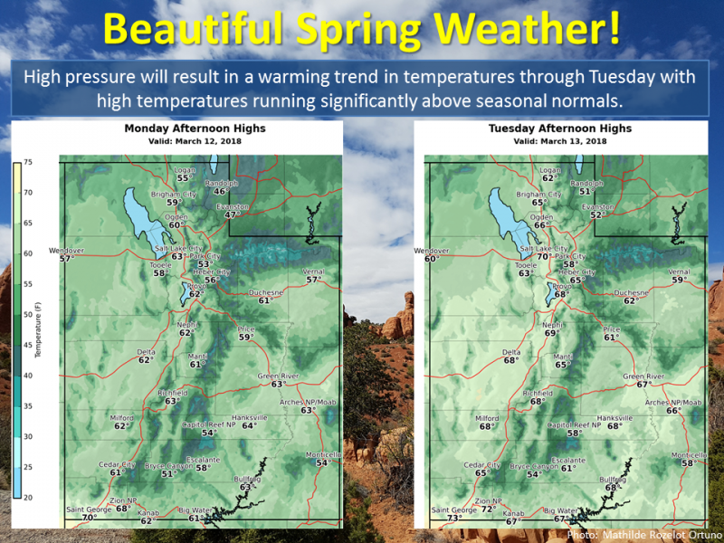
Expect a sunny morning with increasing clouds late in the day as high pressure begins to shift east. Temperatures climb into the 40's with overnight lows near freezing. The next storm system impacts the area later today into tonight. Southerly winds ramp up considerably this evening, gusting into the 60's overnight. Scattered snow showers for Wednesday with a better chance for accumulating snow late in the week. |
| general announcements The information in this advisory expires 24 hours after the date and time posted, but will be updated by 7:00 AM Wednesday March 14th, 2018. If you're getting out and about, please let me know what you're seeing especially if you see or trigger and avalanche. I can be reached at [email protected] or 801-231-2170 It's also a good time to set up one of our very popular avalanche awareness classes. Reach out to me and I'll make it happen. This information does not apply to developed ski areas or highways where avalanche control is normally done. This advisory is from the U.S.D.A. Forest Service, which is solely responsible for its content. This advisory describes general avalanche conditions and local variations always occur. |