25th Annual Black Diamond Fall Fundraising Party
Thursday, September 13; 6:00-10:00 PM; Black Diamond Parking Lot
25th Annual Black Diamond Fall Fundraising Party
Thursday, September 13; 6:00-10:00 PM; Black Diamond Parking Lot
| Advisory: Uintas Area Mountains | Issued by Craig Gordon for Saturday - March 10, 2018 - 4:18am |
|---|

|
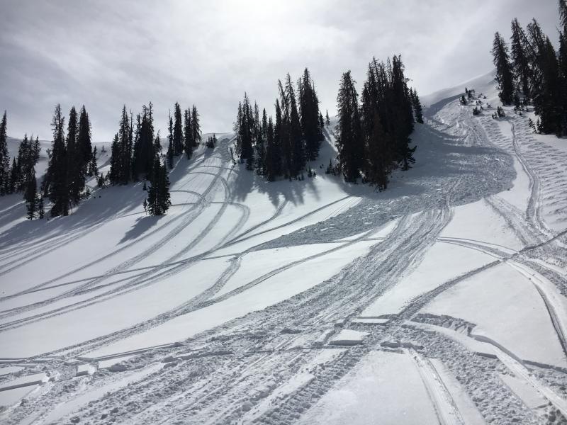
bottom line In upper elevation terrain, especially in the wind zone at and above treeline, the avalanche danger is MODERATE. Human triggered avalanches are POSSIBLE on steep wind drifted slopes facing the north half of the compass, particularly those with an easterly component to their aspect. Any avalanche breaking into weak layers of snow, now buried deeper in our snowpack will quickly ruin your day. LOW avalanche danger exists on mid and lower elevation, wind sheltered terrain and on most slopes facing the south half of the compass.
|
 |
special announcement Don't remember to forget Daylight Savings Time... Spring ahead and change you clocks tonight. |
 |
current conditions High clouds drifted into the region last night along with a weak cold front, dropping temperatures into the teens and 20's. West and northwest winds are blowing 25-35 mph along the high ridges. Sunny slopes are crusted, but riding and turning conditions remain quite good, particularly on mid elevation, wind sheltered, shady slopes.
Above are 24 hour temperatures and snow depth from Chalk Creek along with winds and temperatures from Windy Peak. More remote Uinta weather stations are found here You can find a great body of recent trip reports, observations, and snow data here.
|
 |
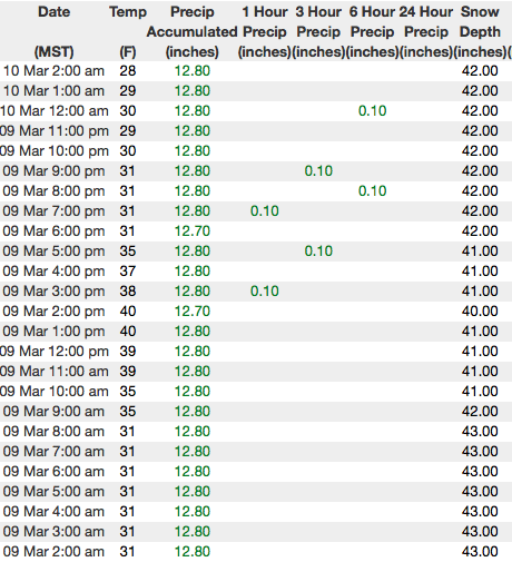
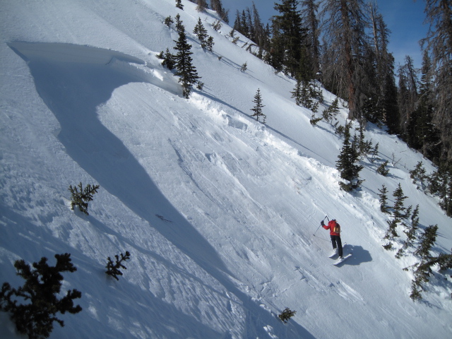
recent activity Three significant human triggered avalanches this week- Tuesday in Chalk Creek
Wednesday in Humpy Creek Thursday in Upper Weber Canyon The recent avy activity we've looked at have a few common themes- they're breaking after a few people have been on the slope, failing on a mid pack facet/crust sandwich, breaking wider and deeper than you might expect, and piling up large piles of debris. More details are found here. |
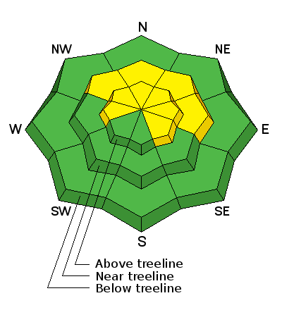
| type | aspect/elevation | characteristics |
|---|

|
|
LIKELIHOOD
 LIKELY
UNLIKELY
SIZE
 LARGE
SMALL
TREND
 INCREASING DANGER
SAME
DECREASING DANGER
|
|
description
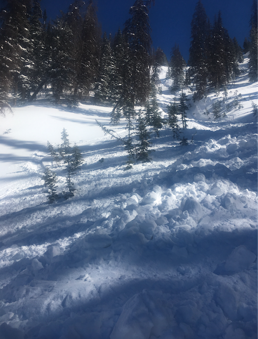
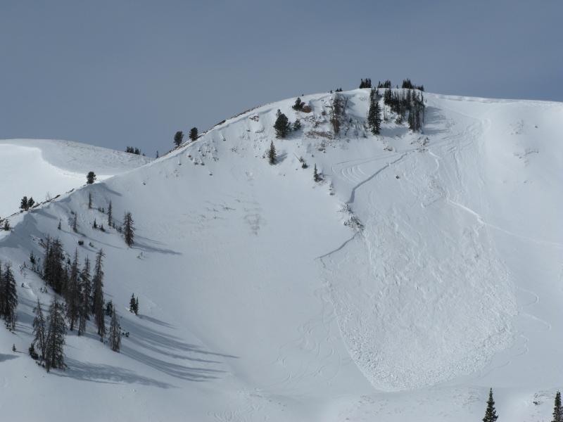
Take a look at the picture above from Wednesday's Humpy Creek slide. Curious that the steep slopes to the lookers left stayed intact, while the nearby slope to the right avalanched. Investigating the avalanche we found just a little nuance in snowpack structure along with a slight midslope breakover. The 4th rider on the slope was able to knock the legs out from under the slab... yep, these are the characteristics of a persistent slab. Just when you're feeling good about stability... bam! You're staring down the barrel of a scary slide. Yes, in most terrain across the range the pack is happy in its own skin. However, the Uinta's are a big zone and I bet there's still a surprise or two lurking out there today. Prime suspects include terrain that has already avalanched this year along with a vast majority of steep, shady slopes that have remained thin and shallow this winter. Terrain with these characteristics remains sketchy and should be considered guilty until proven otherwise. Sounds complicated, but the answer is easy. The way we manage unpredictable avalanche dragons is to simply avoid where they live. If you're looking for powder and safe riding, simply tone down your slope angles and avoid terrian with steep, wind drifted slopes hanging above you. |
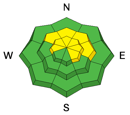
| type | aspect/elevation | characteristics |
|---|

|
|
LIKELIHOOD
LIKELY
UNLIKELY
SIZE
 LARGE
SMALL
TREND
 INCREASING DANGER
SAME
DECREASING DANGER
|
|
description
Not particularly widespread, there might be a rogue drift or two that remains reactive to the additional weight of a rider. Stiff wind slabs are most prevalent on the leeward side of upper elevation ridges and around terrain features like chutes and gullies. Today's hard slabs are gonna be a bit stubborn, but once triggered, can potentially break deeper and wider than you might expect and are gonna pack a punch. You can ride safely today by looking for and avoiding fat, rounded pillows of snow, especially if they sound hollow like a drum. |
 |
weather Expect partly to mostly cloudy skies this weekend as a storm system crosses Arizona and southern Utah. Northwest winds gust to 50 mph this morning, but diminish as the day wares on. High temperatures rise into the 30's with overnight lows dipping into the low 20's. Not much action in the weather department this week, but a glimmer of hope towards the weekend for a more active weather pattern. |
| general announcements The information in this advisory expires 24 hours after the date and time posted, but will be updated by 7:00 AM Sunday March 11th, 2018. If you're getting out and about, please let me know what you're seeing especially if you see or trigger and avalanche. I can be reached at [email protected] or 801-231-2170 It's also a good time to set up one of our very popular avalanche awareness classes. Reach out to me and I'll make it happen. This information does not apply to developed ski areas or highways where avalanche control is normally done. This advisory is from the U.S.D.A. Forest Service, which is solely responsible for its content. This advisory describes general avalanche conditions and local variations always occur. |