25th Annual Black Diamond Fall Fundraising Party
Thursday, September 13; 6:00-10:00 PM; Black Diamond Parking Lot
25th Annual Black Diamond Fall Fundraising Party
Thursday, September 13; 6:00-10:00 PM; Black Diamond Parking Lot
| Advisory: Uintas Area Mountains | Issued by Craig Gordon for Sunday - March 4, 2018 - 5:20am |
|---|


|
bottom line HEADS UP... IF WINDS INCREASE OR WE RECEIVE MORE SNOW THAN FORECAST, THE AVALANCHE DANGER WILL RAPIDLY RISE TO HIGH. For this morning, in upper elevation terrain, especially in the wind zone at and above treeline, the avalanche danger is CONSIDERABLE. Both human triggered and natural avalanches are likely on steep wind drifted slopes facing the north half of the compass, particularly those with an easterly component to their aspect. An avalanche triggered today can quickly get out of hand if it breaks into weak layers of snow, now buried deeper in our snowpack. Winds got into mid elevation terrain as well and you'll encounter a MODERATE avalanche danger on steep slopes with recent deposits of wind drifted snow. LOW avalanche danger exists on lower elevation, wind sheltered terrain and on most slopes facing the south half of the compass.
|
 |
current conditions So... i'm starting to feel like I'm a contestent on "Weather or Not?", a new weather reality TV show where only the producers and the studio audience know the storm isn't really going to materialize, but they keep baiting me in hopes that I'll stick around 'til the bitter end of the series just to watch my utter disappointment as I get Punk'd with a storm that produces all blow and no snow. No really... it is still going to snow and the storm just got going around 3:00 this morning with 2"-3" of snow stacking up in short order. Winds are switching to the west and blowing 30-40 mph along the high ridges and temperatures are in the single digits. Riding and turning conditions are hit or miss this morning and it might be best to wait 'til later in the day and consider a dusk patrol.
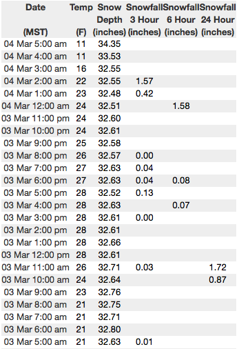
Above are 24 hour temperatures and snow depth from Upper Moffit Basin along with winds and temperatures from Windy Peak. More remote Uinta weather stations are found here
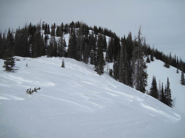
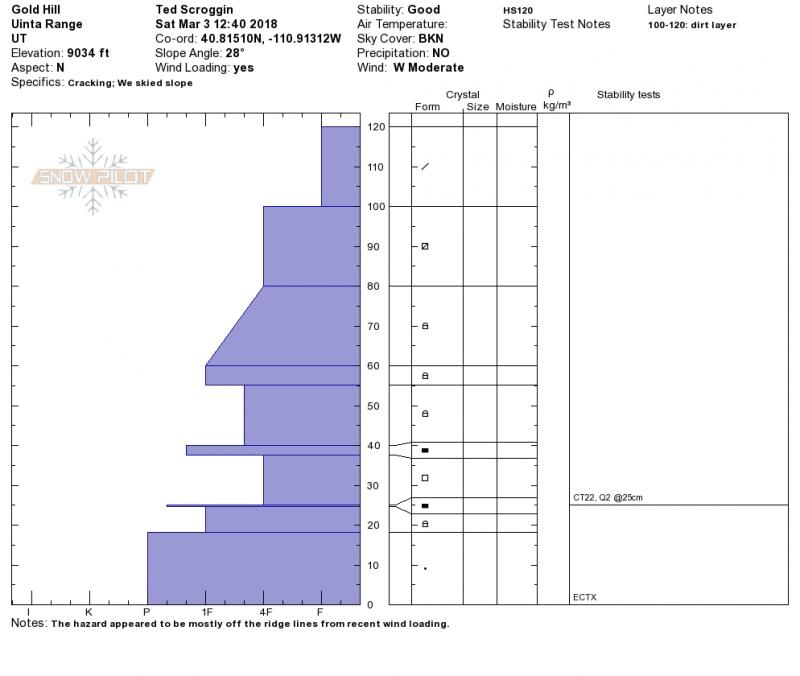
Ted was in Gold Hill yesterday and found wind worked snow, but a relatively strong snowpack. More on is his travels here. You can find a great body of recent trip reports, observations, and snow data here.
|
 |
recent activity
Ted triggered this 16" deep x 50' wide hard slab, on the leeward side of a steep, wind drifted ridgeline.
And meanwhile, back at the ranch, the small pocket pictured above was triggered remotely. While only about 15' wide, it broke close to 2' deep and was definitely big enough to knock you off your feet. |
| type | aspect/elevation | characteristics |
|---|

|
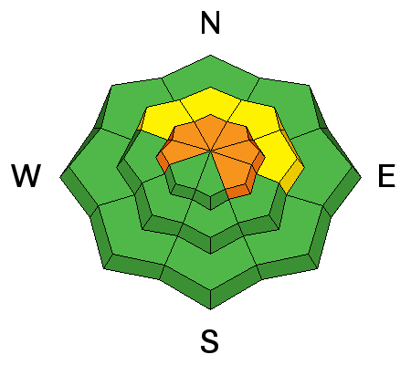
|
LIKELIHOOD
 LIKELY
UNLIKELY
SIZE
 LARGE
SMALL
TREND
 INCREASING DANGER
SAME
DECREASING DANGER
|
|
description
It took a good thump, but the slab pictured above from Thursday started out as a fresh wind drift, then quickly broke into weaker snow buried deeper in the pack. Recent avalanche activity continues to suggest this avalanche dragon isn't healing any time soon. Prime suspects include terrain that has already avalanched this year along with a vast majority of steep, shady slopes that have remained thin and shallow this winter. Terrain with these characteristics remains suspect and should be considered guilty until proven otherwise. Sounds complicated, but the answer is easy. The way we manage unpredictable avalanche dragons is to simply avoid where they live. So today you'll want to steer clear of steep, rocky, wind drifted slopes, especially if they've got a "trapdoor" or punchy feeling. |
| type | aspect/elevation | characteristics |
|---|

|
|
LIKELIHOOD
LIKELY
UNLIKELY
SIZE
 LARGE
SMALL
TREND
INCREASING DANGER
SAME
DECREASING DANGER
|
|
description
Prior to the storm, winds have been all over the place, forming stiff wind slabs on the leeward side of upper elevation ridges and around terrain features like chutes and gullies. Now with a little snow to conceal these hard slabs, today they'll be more difficulkt to detect. But one thing remains the same.... once triggered, today's drifts are gonna break deeper and wider than you might expect and they'll pack a punch. You can ride safely today by looking for and avoiding fat, rounded pillows of snow, especially if they sound hollow like a drum. |
 |
weather We're still thinking snow will continue in earnest with a foot piling up throughout the day. West and northwest winds blow in the 20's and 30's and may bump up slightly later in the day. High temperatures crack into the mid teens with overnight lows dipping into the single digits. Scattered snow showers are on tap for Monday with high pressure building for the rest of the week. |
| general announcements The information in this advisory expires 24 hours after the date and time posted, but will be updated by 7:00 AM Monday March 5th, 2018. If you're getting out and about, please let me know what you're seeing especially if you see or trigger and avalanche. I can be reached at [email protected] or 801-231-2170 It's also a good time to set up one of our very popular avalanche awareness classes. Reach out to me and I'll make it happen. This information does not apply to developed ski areas or highways where avalanche control is normally done. This advisory is from the U.S.D.A. Forest Service, which is solely responsible for its content. This advisory describes general avalanche conditions and local variations always occur. |