25th Annual Black Diamond Fall Fundraising Party
Thursday, September 13; 6:00-10:00 PM; Black Diamond Parking Lot
25th Annual Black Diamond Fall Fundraising Party
Thursday, September 13; 6:00-10:00 PM; Black Diamond Parking Lot
| Advisory: Uintas Area Mountains | Issued by Craig Gordon for Friday - March 2, 2018 - 3:10am |
|---|

|
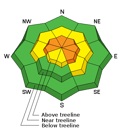
bottom line For today, in upper elevation terrain, especially in the wind zone at and above treeline, the avalanche danger is CONSIDERABLE. Both human triggered and natural avalanches are likely on steep wind drifted slopes facing the north half of the compass, particularly those with an easterly component to their aspect. An avalanche triggered today can quickly get out of hand if it breaks into weak layers of snow, now buried deeper in our snowpack. Winds are getting into mid elevation terrain as well and you'll encounter a MODERATE avalanche danger on steep slopes with recent deposits of wind drifted snow. LOW avalanche danger exists on lower elevation, wind sheltered terrain and on most slopes facing the south half of the compass.
|
 |
avalanche watch * TIMING…IN EFFECT FROM 6 AM MST THIS MORNING TO 6 AM MST SATURDAY * AFFECTED AREA…FOR THE MOUNTAINS OF NORTHERN AND CENTRAL UTAH INCLUDING THE WASATCH RANGE...BEAR RIVER RANGE...UINTA MOUNTAINS...AND THE MANTI-SKYLINE AND WASATCH PLATEAU. * AVALANCHE DANGER…THE AVALANCHE DANGER FOR THE WARNING AREA IS CONSIDERABLE AND IS EXPECTED TO RISE TO HIGH ON SATURDAY. * IMPACTS…STRONG WINDS AND HEAVY SNOWFALL WILL LIKELY CREATE DANGEROUS AVALANCHE CONDITIONS BY SATURDAY, AND CONTINUING THROUGH THE WEEKEND. BOTH HUMAN TRIGGERED AND NATURAL AVALANCHES ARE LIKELY. STAY OFF OF AND OUT FROM UNDER SLOPES STEEPER THAN 30 DEGREES. BACKCOUNTRY TRAVELERS SHOULD CONSULT WWW.UTAHAVALANCHECENTER.ORG OR CALL 1-888-999-4019 FOR MORE DETAILED INFORMATION. THIS WARNING DOES NOT APPLY TO SKI AREAS WHERE AVALANCHE HAZARD REDUCTION MEASURES ARE PERFORMED. |
 |
current conditions Yesterdays little storm was merely the warm up band to the main event and it delivered 3" of new snow across the range. Meanhile, the headliners are plugging in and turning their amps up to 11. Going through the setlist under the guise of a big, bright, beautiful moon... the leading edge of the much anticipated big storm is on our door step. Right around midnight, south and southeast winds increased and are cranking in the 50's and 60's this morning and temperatures are in the mid to upper teens. Riding and turning conditions are hit or miss with all but the most wind sheltered terrain still offering soft, settled snow. It might be a good day to get some projects done, wait for new snow to stack up and get after it over the weekend.
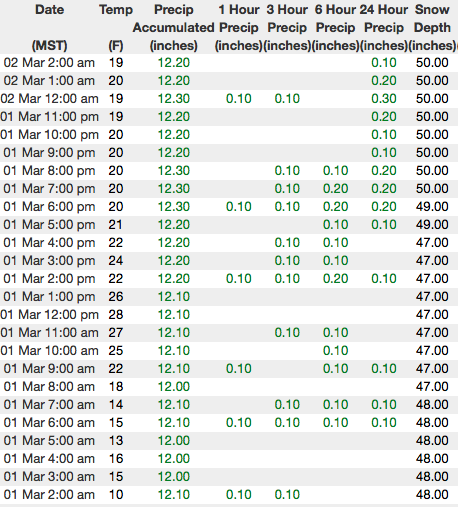
Above are 24 hour temperatures and snow depth from upper Trial Lake along with winds and temperatures from Windy Peak. More remote Uinta weather stations are found here
Ted was in Millcreek yesterday and found variable conditions and a relatively weak snowpack. More on is his travels here. You can find a great body of recent trip reports, observations, and snow data here.
|
 |
recent activity
|
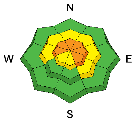
| type | aspect/elevation | characteristics |
|---|

|
|
LIKELIHOOD
 LIKELY
UNLIKELY
SIZE
 LARGE
SMALL
TREND
 INCREASING DANGER
SAME
DECREASING DANGER
|
|
description
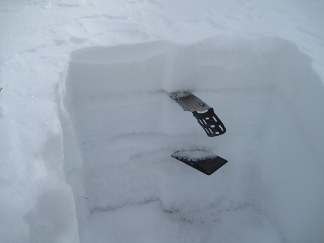
It took a good thump, but the slab pictured above started out as a fresh wind drift, then quickly broke into weaker snow buried deeper in the pack. Recent avalanche activity continues to suggest this avalanche dragon isn't healing any time soon. Prime suspects include terrain that has already avalanched this year along with a vast majority of steep, shady slopes that have remained thin and shallow this winter. Terrain with these characteristics remains suspect and should be considered guilty until proven otherwise. Sounds complicated, but the answer is easy. The way we manage unpredictable avalanche dragons is to simply avoid where they live. So today you'll want to steer clear of steep, rocky, wind drifted slopes, especially if they've got a "trapdoor" or punchy feeling. |
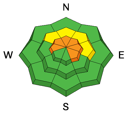
| type | aspect/elevation | characteristics |
|---|

|
|
LIKELIHOOD
LIKELY
UNLIKELY
SIZE
 LARGE
SMALL
TREND
INCREASING DANGER
SAME
DECREASING DANGER
|
|
description
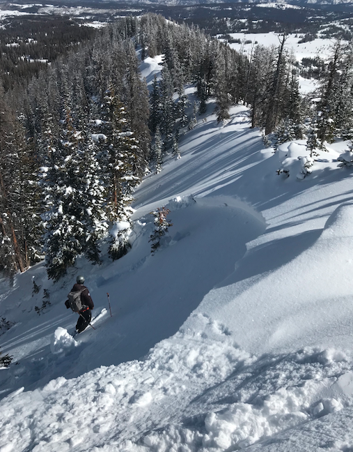
Winds are all over the place and with a couple inches of snow to work with, a fresh batch of stiff wind slabs are forming on the leeward side of upper elevation ridges and around terrain features like chutes and gullies. Once triggered, today's drifts are gonna break deeper and wider than you might expect and they'll pack a punch. You can ride safely today by looking for and avoiding fat, rounded pillows of snow, especially if they sound hollow like a drum. |
 |
weather The storm is taking the scenic route, but still looks on track. Today will be windy and warm with snow showers developing this afternoon. High temperatures climb into the low 30's and southerly winds crank into the 60's and 70's. It looks like snow gets going midday Saturday with a foot or so stacking up by Sunday morning. |
| general announcements The information in this advisory expires 24 hours after the date and time posted, but will be updated by 7:00 AM Saturday March 3rd, 2018. If you're getting out and about, please let me know what you're seeing especially if you see or trigger and avalanche. I can be reached at [email protected] or 801-231-2170 It's also a good time to set up one of our very popular avalanche awareness classes. Reach out to me and I'll make it happen. This information does not apply to developed ski areas or highways where avalanche control is normally done. This advisory is from the U.S.D.A. Forest Service, which is solely responsible for its content. This advisory describes general avalanche conditions and local variations always occur. |