25th Annual Black Diamond Fall Fundraising Party
Thursday, September 13; 6:00-10:00 PM; Black Diamond Parking Lot
25th Annual Black Diamond Fall Fundraising Party
Thursday, September 13; 6:00-10:00 PM; Black Diamond Parking Lot
| Advisory: Uintas Area Mountains | Issued by Craig Gordon for Monday - February 26, 2018 - 3:30am |
|---|


|
bottom line Heads up- the avalanche danger might be slightly more pronounced from about Trial Lake to Strawberry. In upper elevation terrain, especially in the wind zone at and above treeline, the avalanche danger is CONSIDERABLE. Human triggered avalanches are LIKELY on steep wind drifted slopes facing the north half of the compass, particularly those with an easterly component to their aspect. An avalanche triggered today can quickly get out of hand if it breaks into weak layers of snow, now buried deeper in our snowpack. MODERATE avalanche danger exists at mid elevations and human triggered avalanches are possible on steep wind drifted slopes with recent deposits of wind drifted snow. Lose some elevation or switch aspect and you'll find LOW avalanche danger on lower elevation, wind sheltered terrain and on most slopes facing the south half of the compass.
|
 |
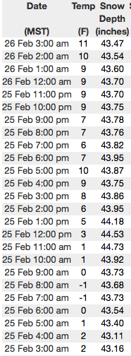
current conditions Clouds thickened overnigt and temperatures are finally out of the deep freeze and into the low teens. Southerly winds increased and are currently blowing in the mid 30's and 40's along the high ridges. There's some wind damage in our big, open upper elevation bowls, but lose a little elevation and head to low angle, wind sheltered terrain and you'll be treated to some of the best riding and turning conditions all year. Above are 24 hour temperatures and snow depth from upper Moffit Basin along with winds and temperatures from Windy Peak. More remote Uinta weather stations are found here You can find a great body of recent trip reports, observations, and snow data here.
|
 |
recent activity
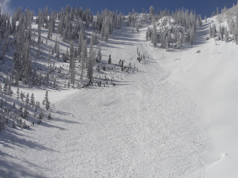
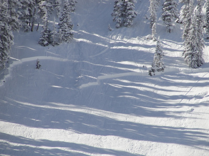
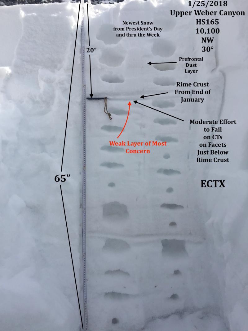
Micheal J was in Weber Canyon yesterday and triggered this avalanche on a steep, northeast facing slope. The avalanche was 18" deep and about 200' wide, breaking deeper and wider than he expected... an unmanageable slide failing on weak facets below the late January rime crust. Micheal provides us solid intel on the snowpack and his valuable insight on things is found here. |
| type | aspect/elevation | characteristics |
|---|

|
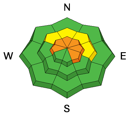
|
LIKELIHOOD
 LIKELY
UNLIKELY
SIZE
 LARGE
SMALL
TREND
 INCREASING DANGER
SAME
DECREASING DANGER
|
|
description
Dormant weak layers in the snowpack are starting to come to life as new storm snow stacks up. Since last Sunday an active storm pattern has added close to 2' of snow to our snowpack and there are a few weak layers that have come out of hibernation. First... facets below a thin rime crust formed in late January have reacted to the additional weight of riders and this combo is responsible for several recently triggered slides. This structure may be more prevelant in Weber Canyon than some of the other terrain throughout the range. Second area of concern is... terrain that harbors weak snow. Prime suspects include terrain that has already avalanched this year along with a vast majority of steep, shady slopes on the south half of the range. Terrain with these characteristics remains suspect and should be considered guilty until proven otherwise. Sounds complicated, but the answer is easy. The way we manage unpredictable avalanche dragons is to simply avoid where they live. So today you'll want to steer clear of steep, rocky, wind drifted slopes, especially if they've got a "trapdoor" or punchy feeling. |
| type | aspect/elevation | characteristics |
|---|

|
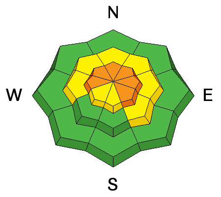
|
LIKELIHOOD
LIKELY
UNLIKELY
SIZE
 LARGE
SMALL
TREND
INCREASING DANGER
SAME
DECREASING DANGER
|
|
description
Wind is always the big game changer for the eastern front and with no shortage of light density snow to blow around, fat drifts sensitive to our additional weight sre starting to form along the leeward side of upper elevation ridges. Today will be tricky because newly formed slabs are now concealed with fresh snow, making them harder to detect. In addition, wind drifts are starting to pack a punch and could definately ruin your way once triggered. So, it's not completely straight-forward and today you'll want to gather as much information as possible. Be on the lookout for clues to unstable snow such as shooting cracks. In addition, tweak small test slopes like road banks and see how they're reacting before getting into steep, commiting terrain. And finally, consider avoiding fat, rounded pillows of snow, especially if they sound hollow like a drum.
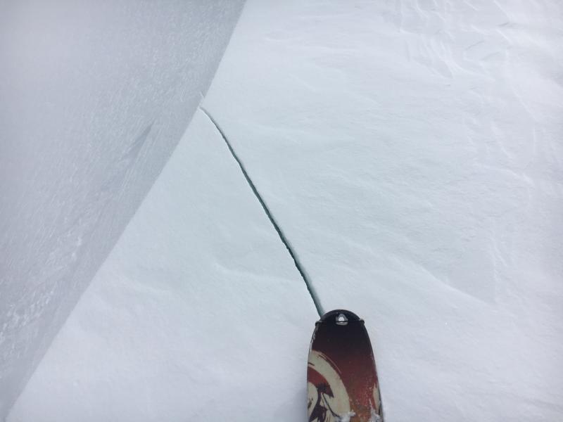
Crackes shooting out in front of you are a huge red flag and solid clue of unstable snow. |
 |
weather Expect a warmer, windy day with scattered snow showers. Highs climb into the 20's and overnight lows dip into the teens. Southwest winds are gonna be obnoxious, blowing in the 40's and 50's along the high ridges. The next significant shot of snow comes late in the week. |
| general announcements The information in this advisory expires 24 hours after the date and time posted, but will be updated by 7:00 AM Tuesday February 26th, 2018. If you're getting out and about, please let me know what you're seeing especially if you see or trigger and avalanche. I can be reached at [email protected] or 801-231-2170 It's also a good time to set up one of our very popular avalanche awareness classes. Reach out to me and I'll make it happen. This information does not apply to developed ski areas or highways where avalanche control is normally done. This advisory is from the U.S.D.A. Forest Service, which is solely responsible for its content. This advisory describes general avalanche conditions and local variations always occur. |