25th Annual Black Diamond Fall Fundraising Party
Thursday, September 13; 6:00-10:00 PM; Black Diamond Parking Lot
25th Annual Black Diamond Fall Fundraising Party
Thursday, September 13; 6:00-10:00 PM; Black Diamond Parking Lot
| Advisory: Uintas Area Mountains | Issued by Craig Gordon for Saturday - February 17, 2018 - 3:04am |
|---|


|
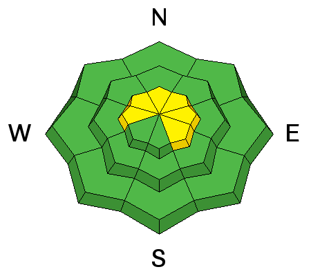
bottom line In mid and upper elevation terrain, especially in the wind zone at and above treeline, the avalanche danger is MODERATE. Human triggered avalanches are possible on steep wind drifted slopes, facing the north half of the compass, particularly those with an easterly component to their aspect. In addition, avalanches breaking to weak, midpack facets remain possible in terrain with these characteristics.
|
 |
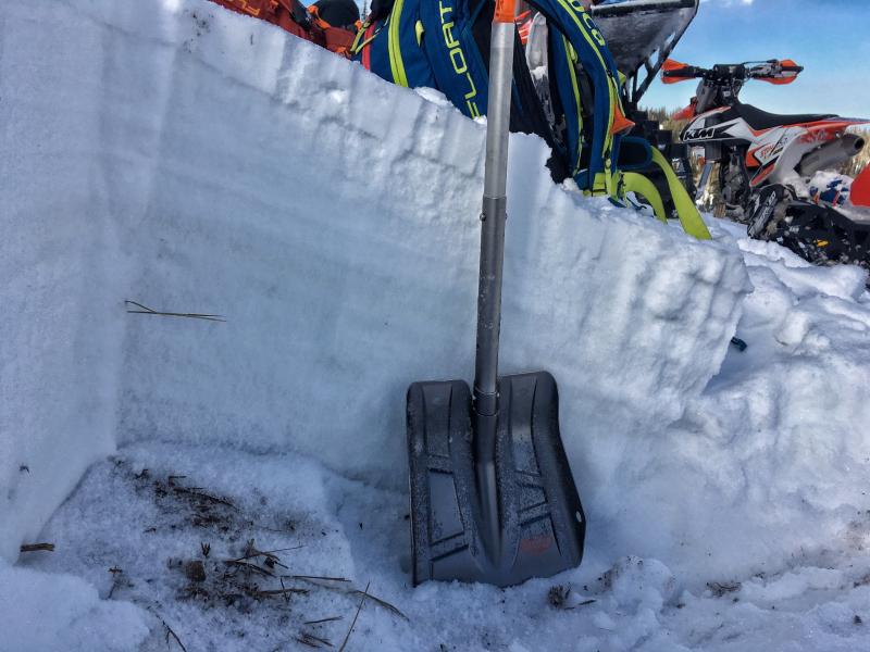
special announcement At 6PM on February 17 at Alpine Distilling in Park City, join a presentation on the UAC's Avalanche Awareness Know Before You Go Program then learn about how we perceive aroma and taste through whiskey while seeing how Alpine Distilling crafts local, award winning spirits. The evening will feature a specialty cocktail made with Alpine Distilling's Persistent (Weak Layer) Vodka and include a raffle for a backcountry kit (beacon, shovel, and probe) donated by Backcountry.com. Contact [email protected] for details and reservations. The Whole Foods Bag Donation to support the UAC has been extended to March 31. When you bring your own bags to Whole Foods in Sugar House, Trolley Square, and Cottonwood Heights you can choose to have the UAC be the recipient of your 10 cent bag credit. |
 |
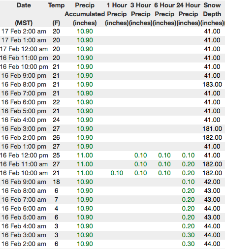
current conditions Skies are clear and temperatures in the single digits and low teens. West and southwest winds are blowing 30-50 mph along the high ridges. Thursday's storm delivered over a foot of light density snow across the range, but recent winds have damaged some of our big, open bowls. Don't fret... mid elevation, wind sheltered terrain remains unscathed and offers deep, creamy snow. Above are 24 hour temperatures and snow depth from Chalk Creek along with winds and temperatures from Windy Peak. More remote Uinta weather stations are found here You can find a great body of recent trip reports, observations, and snow data here.
|
| type | aspect/elevation | characteristics |
|---|

|

|
LIKELIHOOD
 LIKELY
UNLIKELY
SIZE
 LARGE
SMALL
TREND
 INCREASING DANGER
SAME
DECREASING DANGER
|
|
description
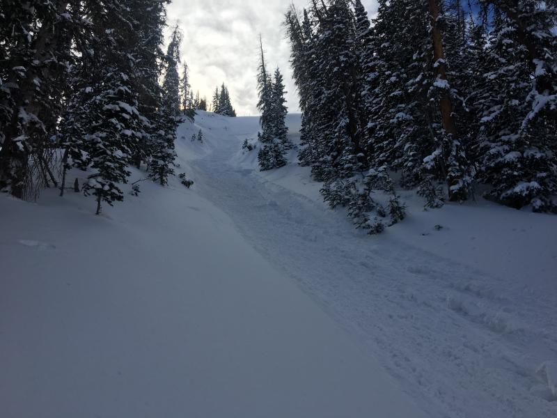
Westin and Shaun's great viddy of a recently triggered Uinta avy says it all... and today it'll be even trickier. Winds are ramping up ahead of tomorrows storm and they'll have no problem forming drifts sensitive to the additional weight of a rider. There's plenty of light snow available for transport and I suspect today's drifts will become more widespread and more connected. Once triggered, they'll definately let you know who's boss. Winds are expected to increase late in the day so you'll want to be on the lookout for and avoid any fat, rounded piece of snow, especially if it sounds hollow like a drum.
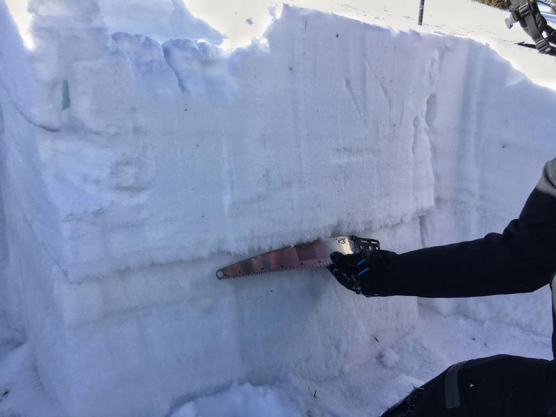
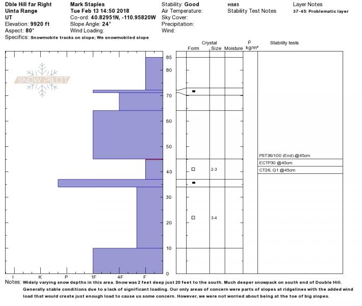
Meanwhile, back at the ranch, Dave Kikkert found this slab on a steep, shady, cross-loaded slope in upper Moffit Basin. |
| type | aspect/elevation | characteristics |
|---|

|
|
LIKELIHOOD
 LIKELY
UNLIKELY
SIZE
 LARGE
SMALL
TREND
INCREASING DANGER
SAME
DECREASING DANGER
|
|
description
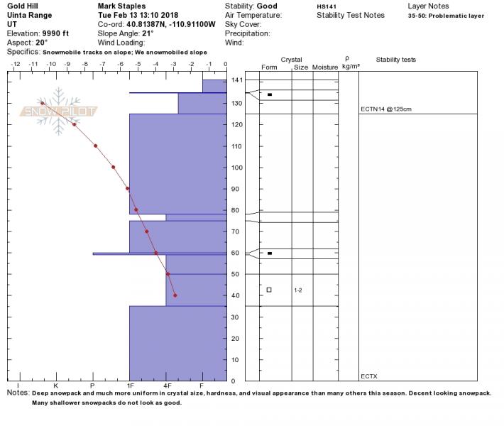
Mark, Toby, Ted, and Trent were stomping around on the North Slope Tuesday and confirmed the suspicions that it's a tale of two snowpacks on the eastern front and there's plenty of variabilty in depth and strength. Thanks to this crew for the great observation. Their collective insight is found here. The Clif Notes version is- where the pack is deep, it's comfortable in it's own skin, resiliant, can take a thump and may be unreactive... that's good news, suggesting we're trending in the right direction.
Where the pack is shallow, it's weaker and will be more reactive with more snow, wind, water, or our additional weight. Suspect terrain includes slopes that avalanched big earlier this season (think Double Hill, Humpy Drainage, Moffit Basin), along with steep, rocky slopes. |
 |
weather
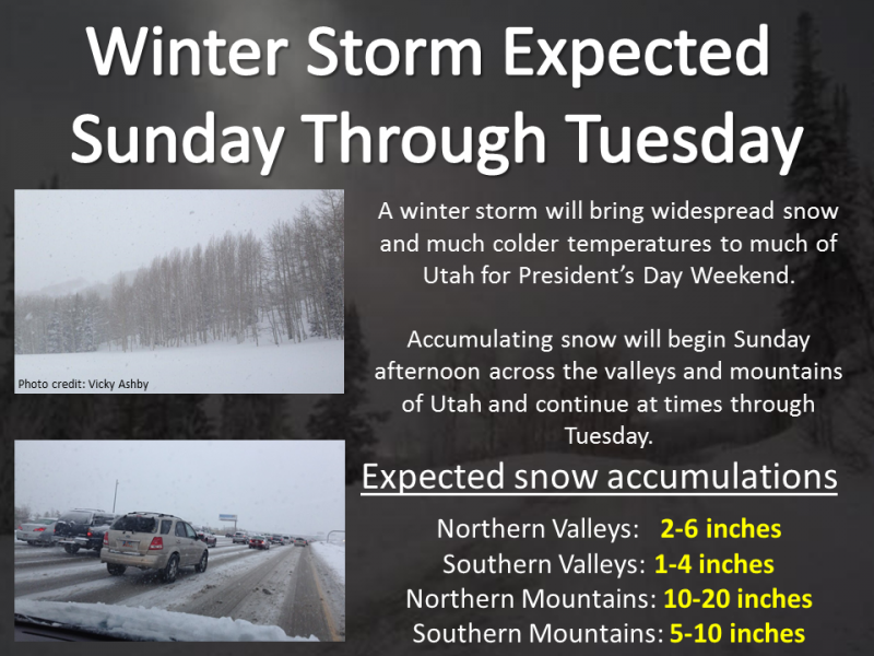
The warm before the storm and the graphic above says it all. Today look for mostly sunny skies, temperatures climbing into the 30's and southwest winds increasing late in the day. Mostly cloudy skies with strong winds and snow developing for Sunday afternoon through the early portion of next week... keep your eyes crossed :) |
| general announcements The information in this advisory expires 24 hours after the date and time posted, but will be updated by 7:00 AM Sunday February 18th, 2018. If you're getting out and about, please let me know what you're seeing especially if you see or trigger and avalanche. I can be reached at [email protected] or 801-231-2170 It's also a good time to set up one of our very popular avalanche awareness classes. Reach out to me and I'll make it happen. This information does not apply to developed ski areas or highways where avalanche control is normally done. This advisory is from the U.S.D.A. Forest Service, which is solely responsible for its content. This advisory describes general avalanche conditions and local variations always occur. |