25th Annual Black Diamond Fall Fundraising Party
Thursday, September 13; 6:00-10:00 PM; Black Diamond Parking Lot
25th Annual Black Diamond Fall Fundraising Party
Thursday, September 13; 6:00-10:00 PM; Black Diamond Parking Lot
| Advisory: Uintas Area Mountains | Issued by Craig Gordon for Wednesday - February 14, 2018 - 2:54am |
|---|

|
bottom line In the wind zone, at and above treeline, the avalanche danger is MODERATE. Human triggered avalanches are possible on steep wind drifted slopes, especially those facing the north half of the compass and particularly those with an easterly component to their aspect. Avalanches breaking to weak, midpack facets remain possible in terrain with these characteristics.
|
 |
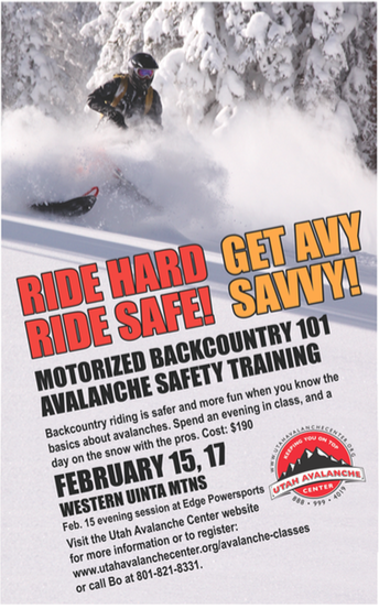
special announcement
We still have a few open slots for this weeks Avy Moto 101. Click here for more details and to register. |
 |
current conditions Skies are partly cloudy and temperatures in the teens and low 20's. A storm is slated to slide through the region later today and southerly winds started cranking just a few hours ago, blowing in the 40's and 50's along the high ridges. Recent storms have stacked up nearly a foot of new snow and riding and turning conditions are surprisingly good, particularly on mid elevation, wind sheltered slopes. Above are 24 hour temperatures and snow depth from Trial Lake along with winds and temperatures from Windy Peak. More remote Uinta weather stations are found here A great body of recent trip reports, observations, and snow data are found here.
|
 |
recent activity Shallow wind slabs and sluffing on steep slopes were reported yesterday, otherwise no significant new avalanche activity. |
| type | aspect/elevation | characteristics |
|---|

|

|
LIKELIHOOD
 LIKELY
UNLIKELY
SIZE
 LARGE
SMALL
TREND
 INCREASING DANGER
SAME
DECREASING DANGER
|
|
description
Winds are always the game changer for the eastern front and the recent bump in winds will instantly transform the landscape, forming drifts sensitive to our additional weight. As winds continue to blow, todays slabs will break deeper and wider than you might expect and can easily boss you around. Found on the leeward side of upper elevation ridges and around terrain features like chutes and gullies, today you'll want to avoid any fat, rounded piece of snow, especially if it sounds hollow like a drum. |
| type | aspect/elevation | characteristics |
|---|

|

|
LIKELIHOOD
 LIKELY
UNLIKELY
SIZE
 LARGE
SMALL
TREND
INCREASING DANGER
SAME
DECREASING DANGER
|
|
description
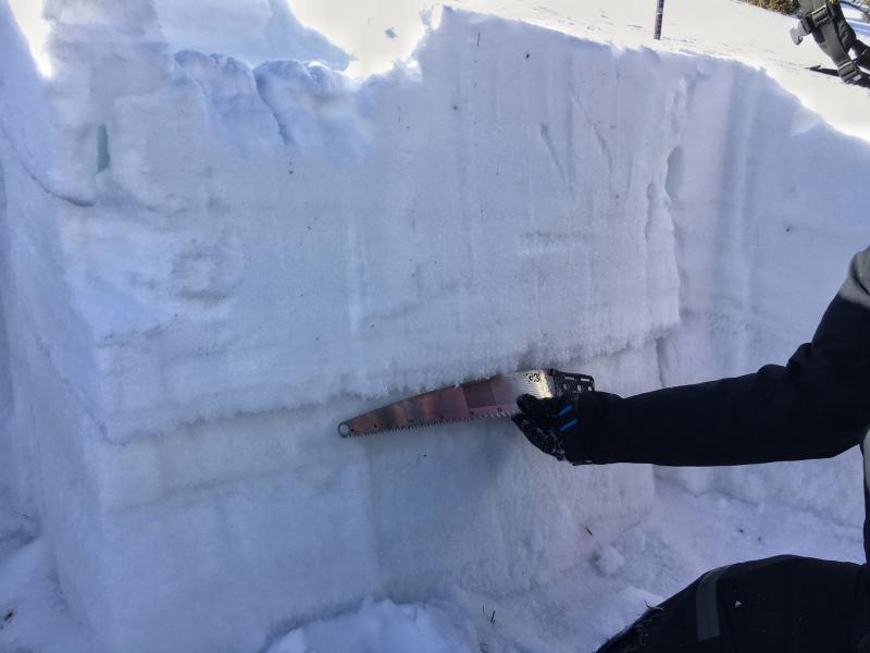
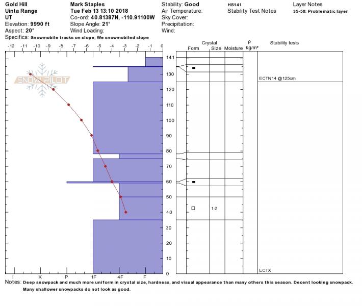
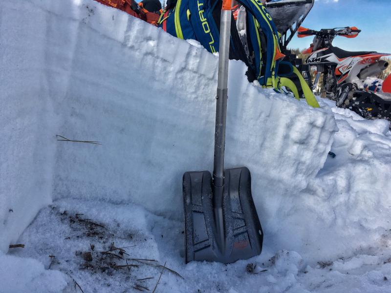
Mark, Toby, Ted, and Trent were stomping around on the North Slope yesterday and confirmed the suspicions that it's a tale of two snowpacks on the eastern front and there's plenty of variabilty in depth and strength. Thanks to this crew for the great observation. Their collective insight is found here. The Clif Notes version is- where the pack is deep, it's comfortable in it's own skin, resiliant, can take a thump and may be unreactive... that's good news, suggesting we're trending in the right direction.
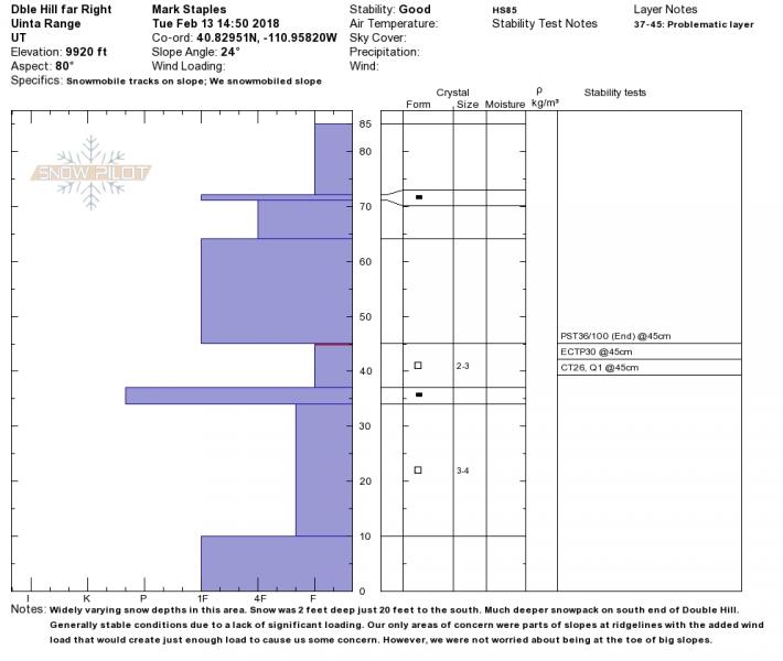
Where the pack is shallow, it's weaker and will be more reactive with more snow, wind, water, or our additional weight. Suspect terrain includes slopes that avalanched big earlier this season (think Double Hill, Humpy Drainage, Moffit Basin), along with steep, rocky slopes. |
 |
weather
Look for increasing clouds with snow developing late in the day. South and southwest winds crank into the 50's and 60's along the high ridges, before switching to the northwest later tonight. Highs reach into the upper 30's with overnight low dipping into the teens. Snow totals in the 6" range look reasonable by midday Thursday. A break in the action for Friday and early Saturday with another system on tap for late Saturday/Sunday. |
| general announcements The information in this advisory expires 24 hours after the date and time posted, but will be updated by 7:00 AM Thursday February 15th, 2018. If you're getting out and about, please let me know what you're seeing especially if you see or trigger and avalanche. I can be reached at [email protected] or 801-231-2170 It's also a good time to set up one of our very popular avalanche awareness classes. Reach out to me and I'll make it happen. This information does not apply to developed ski areas or highways where avalanche control is normally done. This advisory is from the U.S.D.A. Forest Service, which is solely responsible for its content. This advisory describes general avalanche conditions and local variations always occur. |