25th Annual Black Diamond Fall Fundraising Party
Thursday, September 13; 6:00-10:00 PM; Black Diamond Parking Lot
25th Annual Black Diamond Fall Fundraising Party
Thursday, September 13; 6:00-10:00 PM; Black Diamond Parking Lot
| Advisory: Uintas Area Mountains | Issued by Craig Gordon for Tuesday - February 6, 2018 - 2:45am |
|---|

|
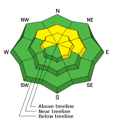
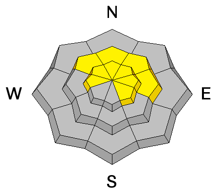
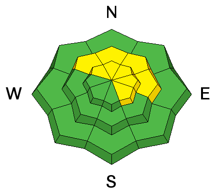
bottom line At and above treeline, in mid and upper elevation terrain, the avalanche danger is MODERATE. Human triggered avalanches are possible on steep, wind drifted slopes, especially those facing the north half of the compass and particularly those with an easterly component to their aspect. Once triggered, today's avalanches can quickly get out of hand if they break into weak layers of snow now buried several feet deep in our snowpack. Most wind sheltered mid and low elevation terrain, especially south facing slopes offer generally LOW avalanche danger.
|
 |
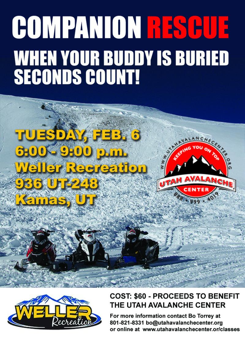
special announcement
There's still a few slots left. Please join us 6:00-9:00 PM, Tuesday Feb. 6th at Weller's Recreation for our Companion Rescue class. Details and registration are found here. Hurry.... operators are still standing by! |
 |
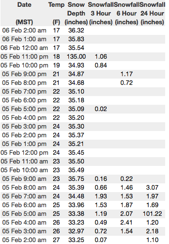
current conditions Last nights storm delivered 2" of fresh, white paint... hardly a primer coat really, but we'll take it none-the-less. In the wake of the storm, skies are partly cloudy and temperatures in the mid teens. Westerly winds are humming along, blowing 30-50 mph near the high peaks. Our little blast of snow will help soften some of the old crusts, fill in tracks, and I bet there's good riding and turning conditions found on mid elevation, wind sheltered slopes.
Above are 24 hour temperatures and snow depth from Upper Moffit Basin along with winds and temperatures from Windy Peak. More remote Uinta weather stations are found here
A super productive Superbowl Sunday getting projects done on the eastern front. Big thanks to Jeff Duenwald for taking time out of his busy life to lend a hand maintaining the Currant Creek Peak wind site and installing a beacon checker at Nobletts Trailhead. Along with being a world class guy, Jeff is also a world class climber and mountaineer. In short... a true BA with first ascents in Alaska in the 60's and 70's. A great body of recent trip reports, observations, and snow data are found here.
|
 |
recent activity
The slide above triggered yesterday in Moffit Basin, clearly illustrates the type of avalanche dragon we're dealing with. Once initiated, today's avalanches will break deeper and wider than you might expect. (C.Brown photo) |
| type | aspect/elevation | characteristics |
|---|

|
|
LIKELIHOOD
 LIKELY
UNLIKELY
SIZE
 LARGE
SMALL
TREND
 INCREASING DANGER
SAME
DECREASING DANGER
|
|
description
Avalanches continue to break near our persistent weakness (seen as the red line in the pit above) now buried 2'-3' deep in the midpack, and the recent string of human triggered slides suggest this problematic layer isn't in a hurry to heal any time soon. It's not a widespread issue, but the consequences remain severe. Once triggered, an avalanche breaking into these layers will quickly get out of hand and instantly ruin our day. The most likely suspects are steep, wind drifted slopes facing north half of the compass. Since this avalanche dragon is unpredictable, the best offense is a good defense... you simply avoid it. Fortunately with a little new snow, the riding conditions are improving and we have more options. Swing around to lower elevation slopes or choose low angle terrain with no steep slopes above or adjacent to the slopes your riding. (C.Brown photo) |
| type | aspect/elevation | characteristics |
|---|

|
|
LIKELIHOOD
LIKELY
UNLIKELY
SIZE
 LARGE
SMALL
TREND
INCREASING DANGER
SAME
DECREASING DANGER
|
|
description
Strong winds are finding enough loose snow to whip into fresh drifts that are sensitive to the additional weight of a person. Found mostly on the leeward side of mid and upper elevation ridges, I bet there's a slab or two lurking around a gully wall or entrance to a chute. In either case, today you'll want to look for and avoid any fat, rounded piece of snow, especially if it sounds hollow like a drum. |
 |
weather A few scattered snow showers are on tap, but in general we'll be drying out and should see clearing skies throughout the day. High temperatures reach into the mid 20's and westerly winds blow in the 30's and 40's along the high ridges. High pressures builds for Wednesday and Thursday. |
| general announcements The information in this advisory expires 24 hours after the date and time posted, but will be updated by 7:00 AM Wednesday February 7th, 2018. If you're getting out and about, please let me know what you're seeing especially if you see or trigger and avalanche. I can be reached at [email protected] or 801-231-2170 It's also a good time to set up one of our very popular avalanche awareness classes. Reach out to me and I'll make it happen. This information does not apply to developed ski areas or highways where avalanche control is normally done. This advisory is from the U.S.D.A. Forest Service, which is solely responsible for its content. This advisory describes general avalanche conditions and local variations always occur. |