25th Annual Black Diamond Fall Fundraising Party
Thursday, September 13; 6:00-10:00 PM; Black Diamond Parking Lot
25th Annual Black Diamond Fall Fundraising Party
Thursday, September 13; 6:00-10:00 PM; Black Diamond Parking Lot
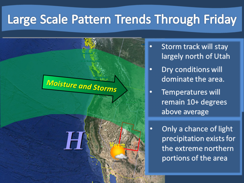
| Advisory: Uintas Area Mountains | Issued by Craig Gordon for Tuesday - January 30, 2018 - 2:46am |
|---|

|
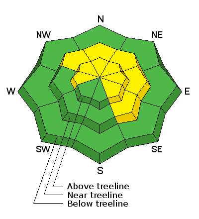
bottom line At and above treeline, in mid and upper elevation terrain, the avalanche danger is MODERATE. Human triggered avalanches are possible on steep, wind drifted slopes, especially those facing the north half of the compass and particularly those with an easterly component to their aspect. Once triggered, today's avalanches can quickly get out of hand if they break into weak layers of snow now buried several feet deep in our snowpack. Most wind sheltered mid and low elevation terrain, especially south facing slopes offer generally LOW avalanche danger.
|
 |
special announcement
Please join me for a current conditions avy presentation this Wednesday at the Kimball Junction Library in PC. I'll talk about the current state of our snowpack and the recent string of human triggered slides. It's guaranteed to be informative, timely, and perhaps even entertaining :) |
 |
current conditions Under clear skies, morning temperatures are in the mid 20's and southwest winds increased right around dinner time, currently blowing 20-30 mph along the high ridges. The powder party got crashed by Sunday's moist, humid weather which laid down a thin coat of rime that sounds like champagne glasses breaking as you ride through it. So, it's a mixed bag out there... amongst the recent rime skin and recent winds that blasted our big open bowls, soft settled snow still exists on wind sheltered, mid elevation, shady terrain.
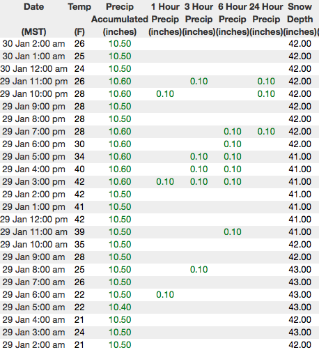
Above are 24 hour temperatures and snow depth from Trial Lake along with winds and temperatures from Windy Peak. More remote Uinta weather stations are found here
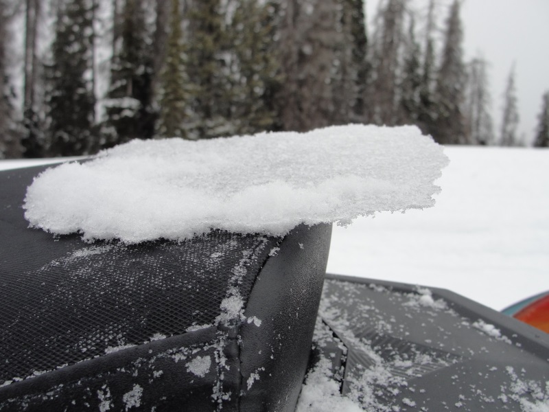
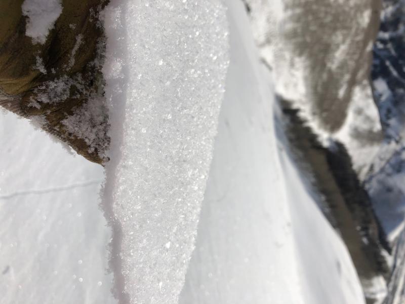
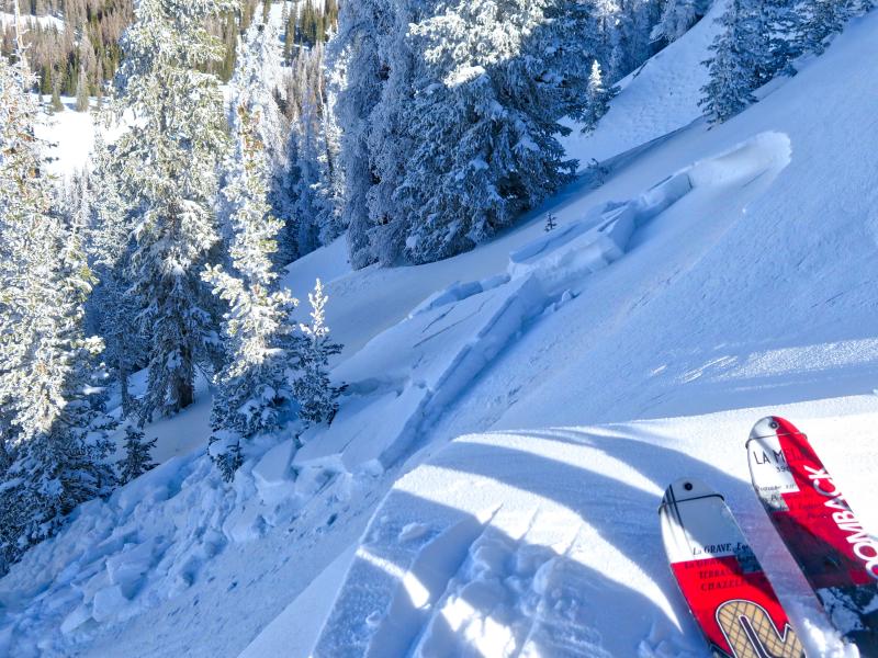
Sunday's rime crust pictured above, wrapped a cargo net on last weeks light, fluffy surface snow. (Janulaitus photo). More troubling is the image below which shows a layer of Surface Hoar that formed on top of the crust Sunday night. Not a problem right now, but definately something to keep an eye on if it gets perserved and buried. (Earle photo)
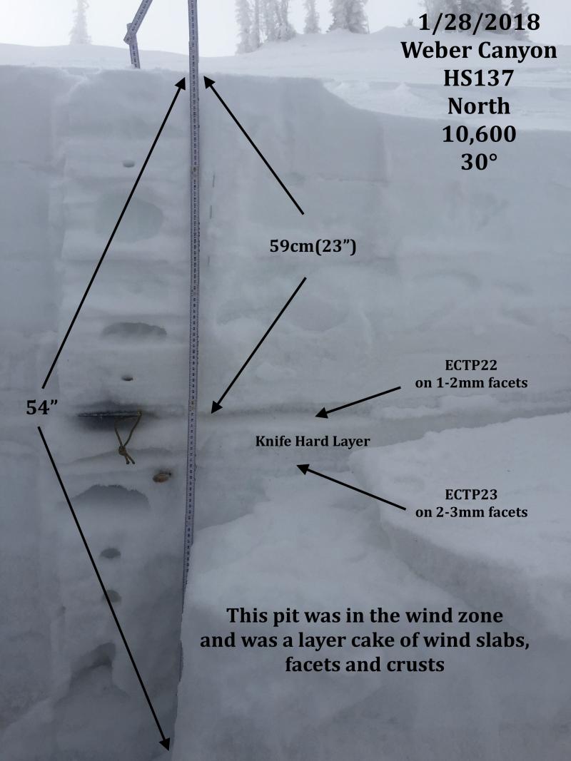
One of JG's beautifully detailed pit profiles from Weber Canyon. There's also a great body of recent trip reports, observations, and snow data found here.
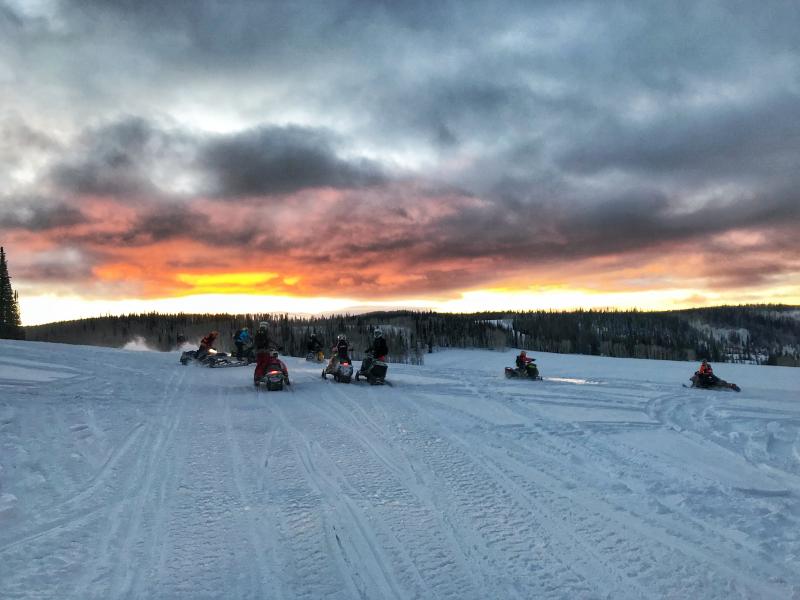
Trent was near Soapstone Sunday and found a stable snowpack and a brilliant sunset. More on his travels here.
|
 |
recent activity
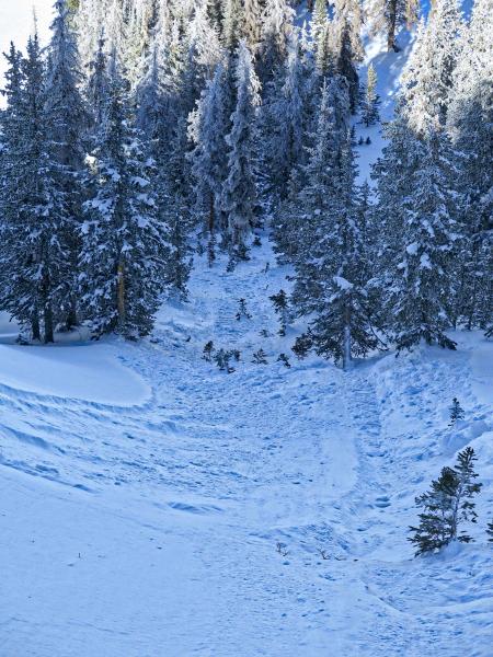
The slide pictured above from Sunday, triggered when a piece of cornice was dropped on, clearly illustrates how quickly a persistent slab gets out of hand and can easily take you for a body beating, season ending ride through a group of trees. In addition, my colleagues posted a great, detailed investigation of the Silver Fork Meadows Chutes accident from Friday and that's found HERE. Even though it's a different mountain range, it a solid read and there's lots of similarities to what's going on with our snowpack. |
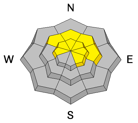
| type | aspect/elevation | characteristics |
|---|

|
|
LIKELIHOOD
 LIKELY
UNLIKELY
SIZE
 LARGE
SMALL
TREND
 INCREASING DANGER
SAME
DECREASING DANGER
|
|
description
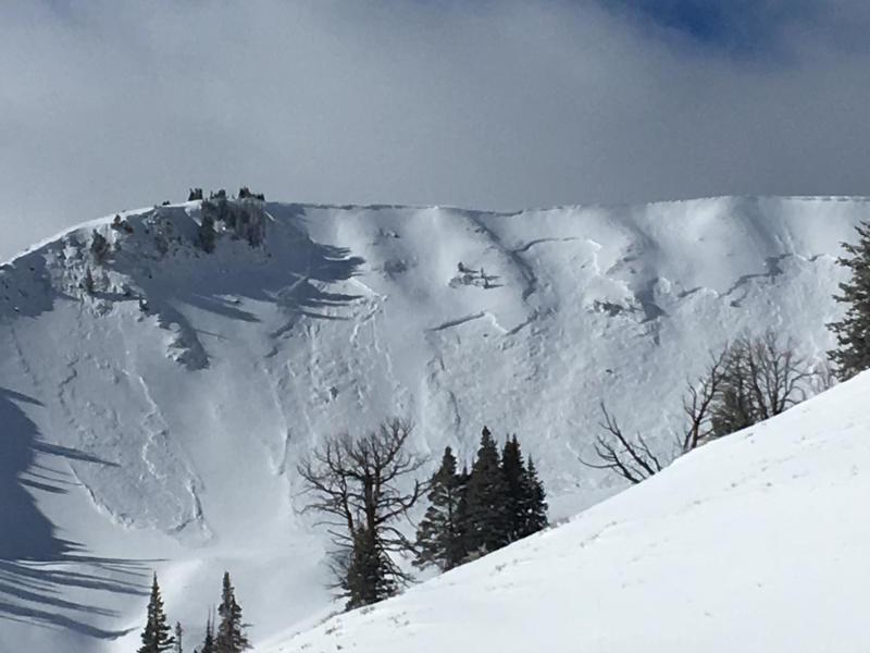
Our persistent weakness buried in the midpack isn't in a hurry to heal and recently triggered slides breaking 2'-3' deep, suggest it's still alive and well. Once triggered, like the slab above from midweek, an avalanche breaking into these layers will quickly get out of hand and instantly ruin our day. The most likely suspects are steep, rocky, wind drifted slopes facing north half of the compass. Since this avalanche dragon is unpredictable, the best offense is a good defense... you simply avoid it. Swing around to lower elevation slopes or choose low angle terrain with no steep slopes above or adjacent to the slopes your riding. (Zimmerman-Wall photo) |
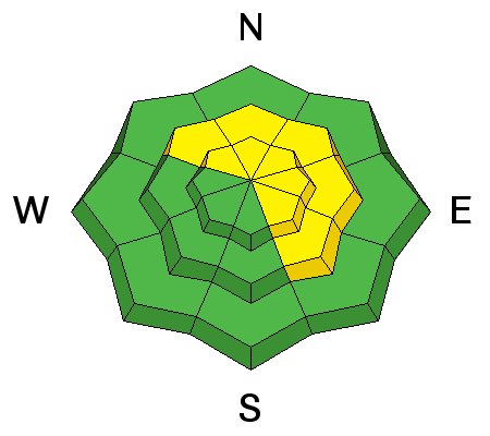
| type | aspect/elevation | characteristics |
|---|

|
|
LIKELIHOOD
LIKELY
UNLIKELY
SIZE
 LARGE
SMALL
TREND
INCREASING DANGER
SAME
DECREASING DANGER
|
|
description
Southwest winds increased overnight and I'm thinking there's enough loose snow available to blow around and form fresh drifts that'll be sensitive to our additional weight. Not particularly widespread, they may none-the-less surprise you on a steep, wind drifted slope. Found mostly on the leeward side of upper elevation ridges, today you'll want to look for and avoid any fat, rounded piece of snow, especially if it sounds hollow like a drum. |
 |
weather
High pressure brings dry and mild weather today with highs reaching into the mid to upper 40's. West and southwest winds increase throughout the day, gusting into the 40's and 50's by late afternoon. A dry cold front crosses the area tonight bringing a cooling trend, but no snow. There are no storms in sight. |
| general announcements The information in this advisory expires 24 hours after the date and time posted, but will be updated by 7:00 AM Wednesday January 31, 2018. If you're getting out and about, please let me know what you're seeing especially if you see or trigger and avalanche. I can be reached at [email protected] or 801-231-2170 It's also a good time to set up one of our very popular avalanche awareness classes. Reach out to me and I'll make it happen. This information does not apply to developed ski areas or highways where avalanche control is normally done. This advisory is from the U.S.D.A. Forest Service, which is solely responsible for its content. This advisory describes general avalanche conditions and local variations always occur. |