25th Annual Black Diamond Fall Fundraising Party
Thursday, September 13; 6:00-10:00 PM; Black Diamond Parking Lot
25th Annual Black Diamond Fall Fundraising Party
Thursday, September 13; 6:00-10:00 PM; Black Diamond Parking Lot
| Advisory: Uintas Area Mountains | Issued by Craig Gordon for Friday - January 26, 2018 - 3:21am |
|---|


|
bottom line In the wind zone at and above treeline the avalanche danger is CONSIDERABLE. Human triggered avalanches are likely on steep, wind drifted slopes, especially those facing the north half of the compass and particularly those with an easterly component to their aspect. Once triggered, today's avalanches can quickly get out of hand if they break into weak layers of snow now buried several feet deep in our snowpack. Mid elevation terrain terrain offers MODERATE avalanche danger and human triggered avalanches are possible on steep leeward slopes with recent deposits of wind drifted snow. Most wind sheltered mid and low elevation terrain, especially south facing slopes offer generally LOW avalanche danger.
|
 |
current conditions Yesterday's quick hitting storm delivered an evenly distributed 7" of light density snow across the range. Under mostly cloudy skies, light snow showers linger. Temperatures crashed to near zero overnight where they hover early this morning. West and southwest winds diminished right around dinner time with the arrival of yesterday's cold front, but are still humming along at 20-30 mph along the high peaks. Recent winds blasted our big open bowls, but soft settled snow is found on wind sheltered, mid elevation, shady terrain.
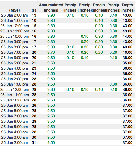
Above are 24 hour temperatures and snow depth from Chalk Creek along with winds and temperatures from Lofty Lake Peak Peak. More remote Uinta weather stations are found here
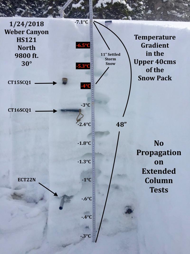
One of JG's beautifully detailed pit profiles from Weber Canyon yesterday, clearly illustrating the snowpack sturcture in that zone. There's a great body of recent trip reports, observations, and snow data found here.
|
 |
recent activity
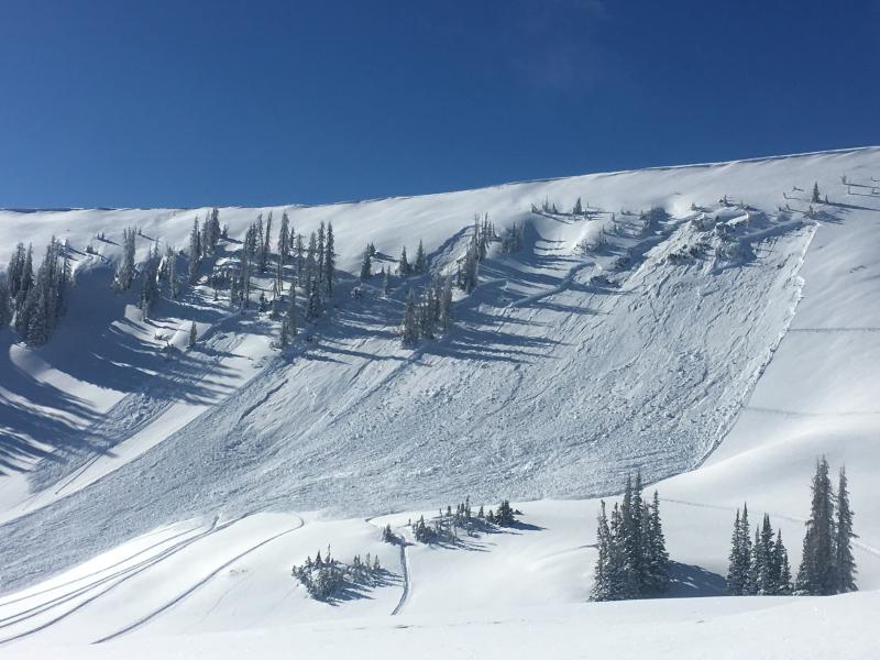
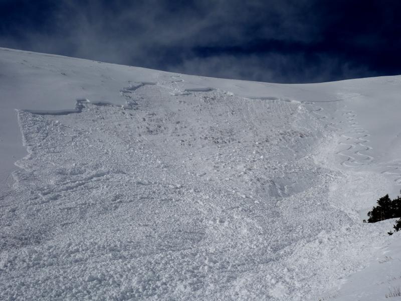
The slab above was triggered low on the slope early Wednesday morning. Yep.... this is what we call a persistent slab. And nope... you don't have to be climbing to kick the legs out from underneath it. Click here to see how this slab is reacting to our additional weight. |
| type | aspect/elevation | characteristics |
|---|

|

|
LIKELIHOOD
 LIKELY
UNLIKELY
SIZE
 LARGE
SMALL
TREND
 INCREASING DANGER
SAME
DECREASING DANGER
|
|
description
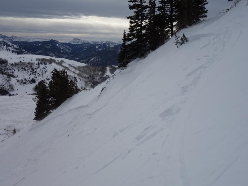
Winds were all over the place yesterday, rapidly forming fresh drifts in upper elevation terrain. While pre-frontal warm temperatures and dense snow made most of these slabs stiff, they were none-the-less still reactive to the additional weight of a rider. With last nights new snow hiding yesterday's wind drifts, they may be harder to detect this morning. However, a keen eye and a quick scan of the landscape helps you identify fat, rounded pillows of snow. Found mostly on the leeward side of upper elevation ridges, I bet a rogue drift or two still lurks around a terrain feature like a chute or gully wall. Today you'll want to avoid steep wind drifted slopes, especially those facing the north half of the compass. (Kikkert photo) |
| type | aspect/elevation | characteristics |
|---|

|

|
LIKELIHOOD
LIKELY
UNLIKELY
SIZE
 LARGE
SMALL
TREND
 INCREASING DANGER
SAME
DECREASING DANGER
|
|
description
Once triggered, like the slab above from Wednesday, an avalanche breaking into weak layers of snow now buried in our midpack, will quickly get out of hand and instantly ruin our day. The most likely suspects are steep, rocky, wind drifted slopes facing north half of the compass. Since this avalanche dragon is unpredictable, the best offense is a good defense... you simply avoid it. Swing around to lower elevation south facing slopes or choose low angle terrain with no steep slopes above or adjacent to the slopes your riding. (Kikkert photo) |
 |
weather Scattered snow showers linger over the area this morning, before high pressure builds through the weekend. Temperatures struggle to get into the teens and overnight lows once again crash to near zero. Winds diminish throughout the day. It looks like a beautiful weekend with clear skies and warming temperatures.r |
| general announcements The information in this advisory expires 24 hours after the date and time posted, but will be updated by 7:00 AM Saturday January 27, 2018. If you're getting out and about, please let me know what you're seeing especially if you see or trigger and avalanche. I can be reached at [email protected] or 801-231-2170 It's also a good time to set up one of our very popular avalanche awareness classes. Reach out to me and I'll make it happen. This information does not apply to developed ski areas or highways where avalanche control is normally done. This advisory is from the U.S.D.A. Forest Service, which is solely responsible for its content. This advisory describes general avalanche conditions and local variations always occur. |