25th Annual Black Diamond Fall Fundraising Party
Thursday, September 13; 6:00-10:00 PM; Black Diamond Parking Lot
25th Annual Black Diamond Fall Fundraising Party
Thursday, September 13; 6:00-10:00 PM; Black Diamond Parking Lot
| Advisory: Uintas Area Mountains | Issued by Craig Gordon for Friday - January 19, 2018 - 4:20am |
|---|

|
bottom line HEADS UP.... EXPECT A RISING DANGER LATE TODAY INTO SATURDAY In the wind zone at and above treeline the avalanche danger is MODERATE. Human triggered avalanches are possible on steep, wind drifted slopes, especially those facing the north half of the compass and particularly those with an easterly component to their aspect. Most mid and low elevation south facing slopes and terrain that held no snow prior to the Christmas Eve storm offer generally LOW avalanche danger.
|
 |
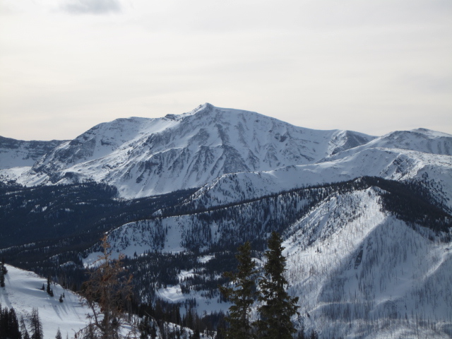
current conditions Winds are cranking into the 50's, temperatures are in the mid 20's, and clouds are streaming into the region, ahead of a good looking storm slated to reach our area later today. The snow surface is a bit tired and many popular slopes are tracked out. Might be a good day to get some projects done and get after it tomorrow with a fresh coat of white paint.
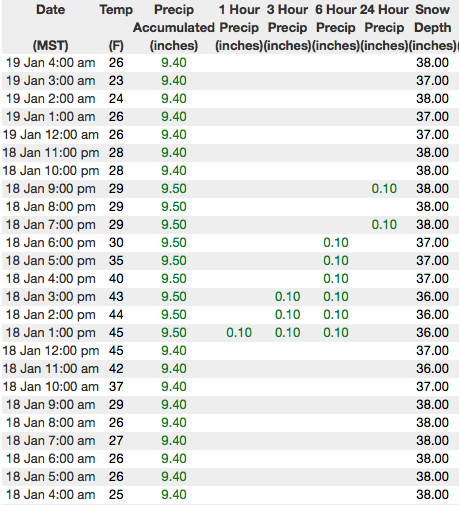
Above are 24 hour temperatures and snow depth from Trial Lake along with winds and temperatures from Lofty Lake Peak. More remote Uinta weather stations are found here
Ted was on the east side of the range yesterday and no surprise... found a shallow, weak snowpack. More on his travels and insights along with a string of recent trip reports can be seen here.
|
 |
recent activity
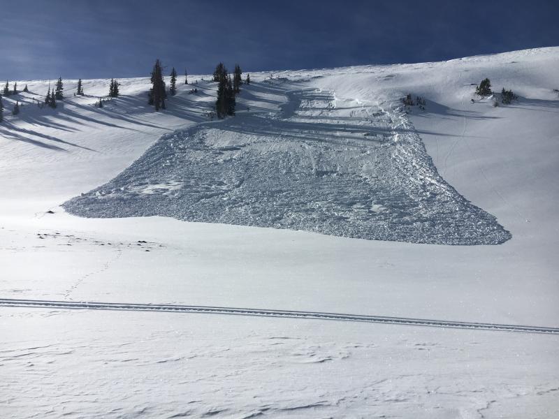
I looked at this slide in Upper Moffit Basin which was triggered low on the slope and fits the recent pattern where avalanches are triggered either mid-slope or from a distance. Common denominator- slides are failing in the midpack or close to the ground. The other common theme is steep leeward slopes facing the north half of the compass. Click here to see recent avy activity. (Gordon photo) Click HERE for a viddy showing what's going on with our snowpack.
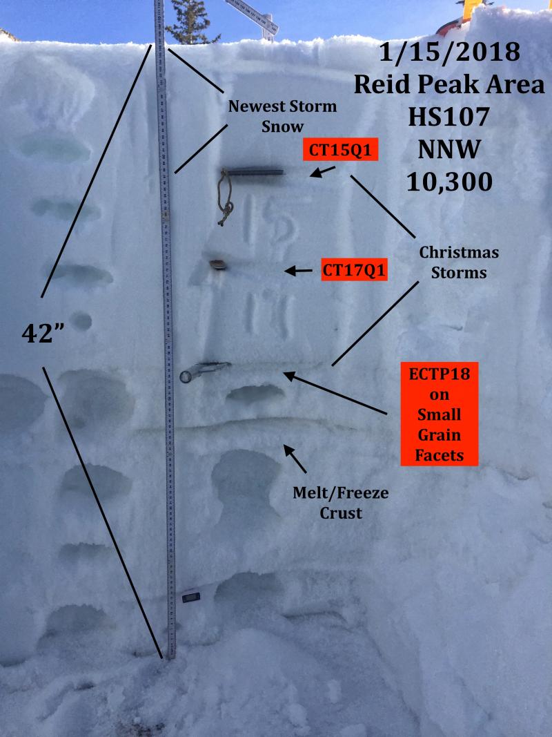
JG's pit from Reids Peak Monday clearly shows where the weak snow lives and his pit results, along with the recent string of human triggered slides, reveals we're not out of the woods yet. |
| type | aspect/elevation | characteristics |
|---|

|

|
LIKELIHOOD
 LIKELY
UNLIKELY
SIZE
 LARGE
SMALL
TREND
 INCREASING DANGER
SAME
DECREASING DANGER
|
|
description
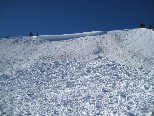
The avalanche pictured above on Yamaha Hill, was one of the last human triggered slides that we know of and it occurred earlier this week on Monday January 15th. Of course, the lack of avy activity is good news and indicates the slab is relaxing and for the moment, the snowpack is comfortable in its own skin.... for the moment. The bigger picture is... we have a complex snowpack and this seasons history reveals that everytime it snows, weak layers in our midpack wake up and we see a string of human triggered slides. Today is a transition day and the avalanche danger is pretty straight-forward. However, with a good shot of snow headed our way tonight and tomorrow, I expect the snowpack will come to life and weak layers buried in our snowpack will get cranky. Look for the avalanche danger to ramp up as the storm evolves.
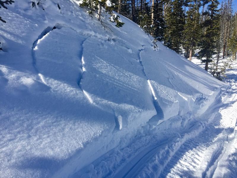
Take advantage of small test slopes like the one pictured above. Tweak them to see how the snow is reacting before committing to a bigger slope objective. A small avalanche like the one pictured above gives me a huge piece of information about the snow stability and the type of avalanche dragon I'm dealing with. |
| type | aspect/elevation | characteristics |
|---|

|

|
LIKELIHOOD
 LIKELY
UNLIKELY
SIZE
 LARGE
SMALL
TREND
INCREASING DANGER
SAME
DECREASING DANGER
|
|
description
I'm sure this mornings winds are finding enough loose snow to whip into fresh wind drifts that'll be sensitive to our additional weight, As the storm materializes later today, drifts will become more widespread and connected. As always, look for and avoid any fresh wind drift, especially if it's fat and rounded or sounds hollow like a drum. |
 |
weather A cold Pacific storm system moves into Utah this afternoon and we can expect a good dose of snow later today. In the mean-time, south and southwest winds crank into the 50's and 60's along the high ridges and high temperatures reach into the low 40's The cold front slides through the region around 8pm and winds become light and northwesterly. The storm settles over the area for Saturday and we should stack up about of foot of snow by late in the day. |
| general announcements The information in this advisory expires 24 hours after the date and time posted, but will be updated by 7:00 AM Saturday January 20, 2018. If you're getting out and about, please let me know what you're seeing especially if you see or trigger and avalanche. I can be reached at [email protected] or 801-231-2170 It's also a good time to set up one of our very popular avalanche awareness classes. Reach out to me and I'll make it happen. This information does not apply to developed ski areas or highways where avalanche control is normally done. This advisory is from the U.S.D.A. Forest Service, which is solely responsible for its content. This advisory describes general avalanche conditions and local variations always occur. |