25th Annual Black Diamond Fall Fundraising Party
Thursday, September 13; 6:00-10:00 PM; Black Diamond Parking Lot
25th Annual Black Diamond Fall Fundraising Party
Thursday, September 13; 6:00-10:00 PM; Black Diamond Parking Lot
| Advisory: Uintas Area Mountains | Issued by Craig Gordon for Wednesday - January 17, 2018 - 4:03am |
|---|

|
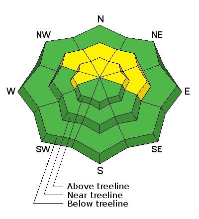
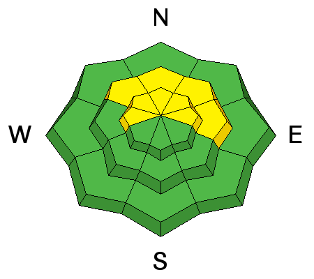
bottom line In the wind zone at and above treeline the avalanche danger is MODERATE. Human triggered avalanches are possible on steep, wind drifted slopes, especially those facing the north half of the compass and particularly those with an easterly component to their aspect. Most mid and low elevation south facing slopes and terrain that held no snow prior to the Christmas Eve storm offer generally LOW avalanche danger.
|
 |
special announcement The information in this advisory expires 24 hours after the date and time posted, but will be updated by 7:00 AM Friday January 19, 2018.
This weekends Sled Avy 101 provided the crew pictured above with a solid skill-set they can take anywhere and make the right decisions based on the avalanche danger and snowpack structure. Huge thanks to Park City Powder Cats for hosting and to The Backcountry Institute for providing a bitchin' workshop. |
 |
current conditions Skies are clear and temperatures in the low to mid 20's. Northwest winds are light, blowing less than 20 mph even along the high ridges. Last weeks storm cycle did the Eastern Front a solid, delivering just over 2' of dense, spongy snow. While it's still pretty thin out there, riding and turning conditions are quite good.
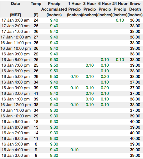
Above are 24 hour temperatures and snow depth from Trial Lake along with winds and temperatures from Windy Peak. More remote Uinta weather stations are found here Recent trip reports and findings can be seen here.
|
 |
recent activity
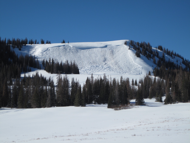
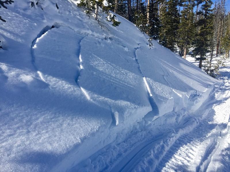
In late breaking news... Ted saw this slide on Yamaha Hill on his way to work yesterday. It fits the recent pattern where avalanches were triggered either mid-slope or from a distance. Common denominator- slides are failing in the midpack or close to the ground. The other common theme is steep leeward slopes facing the north half of the compass. Click here to see recent avy activity. (Scroggin photo) Click HERE for a viddy showing what's going on with our snowpack.
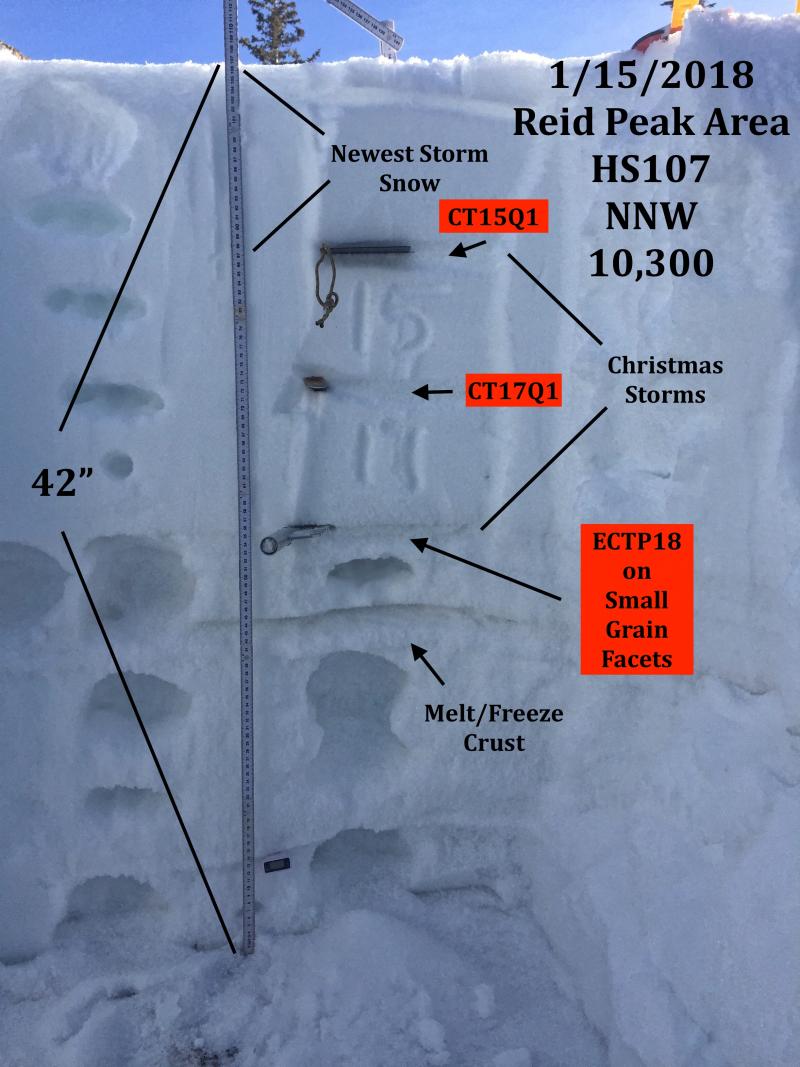
JG's pit from Reids Peak Monday clearly shows where the weak snow lives and his pit results, along with the recent string of human triggered slides, reveals we're not out of the woods yet. |
| type | aspect/elevation | characteristics |
|---|

|
|
LIKELIHOOD
 LIKELY
UNLIKELY
SIZE
 LARGE
SMALL
TREND
 INCREASING DANGER
SAME
DECREASING DANGER
|
|
description
This slide pictured above on Yamaha hill was triggered sometime Monday. Of course, it clearly fits the pattern of recent avalanche activity we've seen in the aftermath of last weeks storm and verifies the fact that we can still trigger persistent slabs on steep, wind drifted slopes. There have been a string of human triggered slides and near misses this week and we've dodged plenty of bullets. Making the current setup tricky is the continued possibility of triggering a slide from low on the slope or even from a distance. Once you've collapsed the slope, all bets are off and you're staring down the barrel of a scary slide. Click HERE for a viddy overview of this avalanche. So here's what's going on... we finally added enough weight for avalanches to begin breaking into weak layers of snow buried in the mid portion of our snowpack. Problem is, the avalanche danger isn't in your face. You don't look around and see avalanches everywhere. On the contrary... many steep slopes still remain in the balance today, just waiting for a trigger like us to roll up and knock the legs out from underneath it. So, how do you manage an unmanageable avalanche dragon? First off, you don't have to roll the dice and take your chances. Second, it doesn't mean you can't ride. Third, it does mean you need to stay off of and out from under steep, wind drifted slopes. By now you know the usual suspects to avoid... steep, upper elevation, shady slopes, especially those facing the north half of the compass. You can have a blast by simply swinging around to slopes that face the south half of the compass where the problem DOESN'T exist. Done, done, and done :)
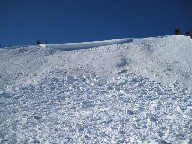
Take advantage of small test slopes like the one pictured above. Tweak them to see how the snow is reacting before committing to a bigger slope objective. A small avalanche like the one pictured above gives me a huge piece of information about the snow stability and the type of avalanche dragon I'm dealing with. |
 |
weather
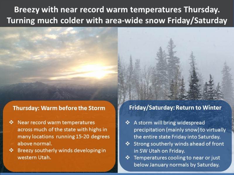
High pressure brings mostly sunny skies and mild temperatures today with highs reaching into the upper 30's. Winds remain light and westerly blowing in the teens. Winds ramp up and clouds thicken Thursday. A cold front slides through the region late Friday afternoon. Heavy snow is likely along and for several hours behind the front. Occasionally heavy snow showers will persist into Saturday night before tapering off. A foot of snow, perhaps slightly more is a good bet by Saturday afternoon. |
| general announcements The information in this advisory expires 24 hours after the date and time posted, but will be updated by 7:00 AM Friday January 19, 2018. If you're getting out and about, please let me know what you're seeing especially if you see or trigger and avalanche. I can be reached at [email protected] or 801-231-2170 It's also a good time to set up one of our very popular avalanche awareness classes. Reach out to me and I'll make it happen. This information does not apply to developed ski areas or highways where avalanche control is normally done. This advisory is from the U.S.D.A. Forest Service, which is solely responsible for its content. This advisory describes general avalanche conditions and local variations always occur. |