25th Annual Black Diamond Fall Fundraising Party
Thursday, September 13; 6:00-10:00 PM; Black Diamond Parking Lot
25th Annual Black Diamond Fall Fundraising Party
Thursday, September 13; 6:00-10:00 PM; Black Diamond Parking Lot
| Advisory: Uintas Area Mountains | Issued by Craig Gordon for Tuesday - January 9, 2018 - 3:02am |
|---|

|
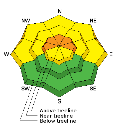
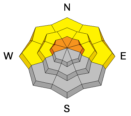
bottom line HEADS UP... IT'LL BE A DAY OF RISING AVALANCHE DANGER At and above treeline the avalanche danger is CONSIDERABLE. Human triggered avalanches are likely and natural avalanches possible on steep, wind drifted slopes, especially those facing the north half of the compass. Mid elevation terrain offers MODERATE avalanche danger and human triggered avalanches are possible on steep slopes with recent deposits of wind drifted snow. Most mid and low elevation south facing slopes and terrain that held no snow prior to the Christmas Eve storm offer generally LOW avalanche danger.
|
 |
avalanche watch THE FOREST SERVICE UTAH AVALANCHE CENTER IN SALT LAKE CITY HAS ISSUED A BACKCOUNTRY AVALANCHE WATCH. * TIMING…IN EFFECT FROM 6 AM MST THIS MORNING TO 6 AM MST WEDNESDAY * AFFECTED AREA…FOR THE MOUNTAINS OF NORTHERN UTAH INCLUDING THE WASATCH RANGE...PROVO AREA MOUNTAINS...BEAR RIVER RANGE...WESTERN UINTA MOUNTAINS...WASATCH PLATEAU/MANTI SKYLINE...FISH LAKE AREA MOUNTAINS.... * AVALANCHE DANGER…THE AVALANCHE DANGER IS EXPECTED TO RISE SIGNIFICANTLY WITH ADDITIONAL SNOW AND WIND. POSSIBLY REACHING HIGH BY WEDNESDAY. * IMPACTS…HEAVY SNOW AND STRONG WINDS WILL LEAD TO VERY DANGEROUS AVALANCHE CONDITIONS. NATURAL AND HUMAN TRIGGERED AVALANCHES ARE LIKELY. AS AVALANCHES MAY BE TRIGGERED FROM BELOW, STAY OFF OF AND OUT FROM UNDERNEATH STEEP MOUNTAIN SLOPES. BACKCOUNTRY TRAVELERS SHOULD CONSULT WWW.UTAHAVALANCHECENTER.ORG OR CALL 1-888-999-4019 FOR MORE DETAILED INFORMATION. THIS WARNING DOES NOT APPLY TO SKI AREAS WHERE AVALANCHE HAZARD REDUCTION MEASURES ARE PERFORMED Click here to see what's going on with our snowpack. |
 |
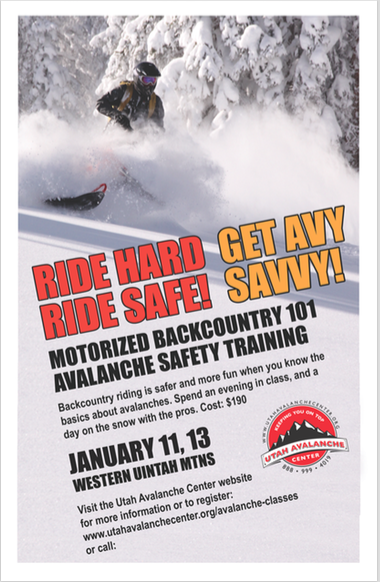
special announcement
We still have a few open slots available for this weeks Motorized Backcountry 101 Workshop. Click here for more details and to register. |
 |
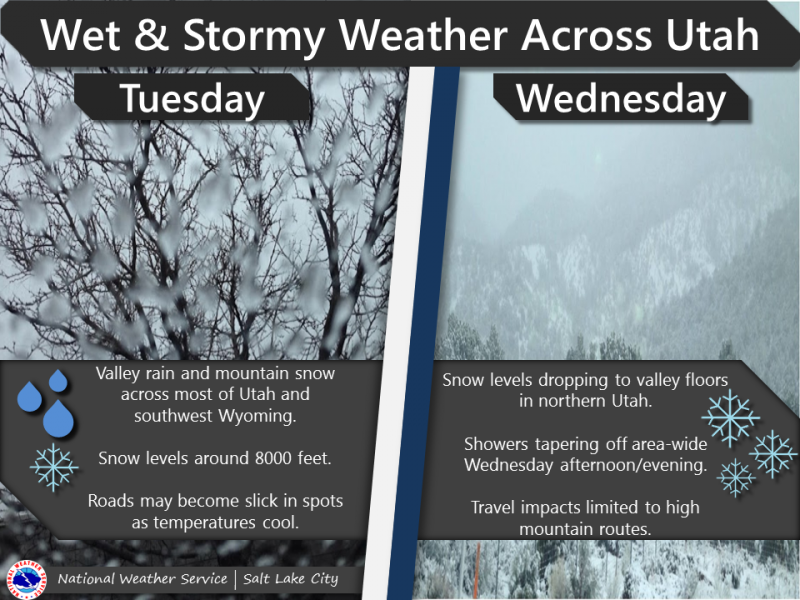
current conditions The first in a series of storms rolled into the region overnight delivering 3" of dense, spongy snow. It's a warm storm and temperatures are in the mid and upper 20's. Southeast winds are blowing 30-50 mph along the high peaks. Since Saturday, the range received 6"-8" of new snow and while it's still super boney out there, riding and turning conditions have vastly improved.
Above are 24 hour temperatures and snow depth from Trial Lake along with winds and temperatures from Lofty Lake Peak. More remote Uinta weather stations are found here Recent trip reports and findings can be seen here. |
 |
recent activity No new avalanches to report. Click here to see recent avy activity. |
| type | aspect/elevation | characteristics |
|---|

|
|
LIKELIHOOD
 LIKELY
UNLIKELY
SIZE
 LARGE
SMALL
TREND
 INCREASING DANGER
SAME
DECREASING DANGER
|
|
description
Winds ramped up yesterday and they've been blowing all night. With some new snow to work, fresh wind drifts forming on the leeward side of upper elevation ridges are gonna be today's most obvious avalanche hazard. As the storm materializes, look for and avoid any recent deposit of wind drifted snow, especially if it's fat and rounded or sounds hollow like a drum. By late in the day, drifts will be become more widespread, more sensitive, and may start to break deeper than you might expect. |
| type | aspect/elevation | characteristics |
|---|

|
|
LIKELIHOOD
LIKELY
UNLIKELY
SIZE
LARGE
SMALL
TREND
INCREASING DANGER
SAME
DECREASING DANGER
|
|
description
It's been pretty quiet on the eastern front the past few days, but with a mulit-day storm on tap, the avalanche hazard will begin to change. And here's why... on shady slopes facing the north half of the compass, we've got a complex snowpack. It's structure is unusual because not only do we have weak faceted snow, there's a few crusts thrown in the mix and they're sandwiched in between this mini house of cards. While this "persistent slab" issue has remained dormant for nearly a week, I bet it'll come back to life as winds continue howling and we stack up some snow and water weight. By now you know the usual suspects to avoid... steep, rocky, upper elevation slopes, especially those facing the north half of the compass. |
 |
weather
Warm, wet, and windy today as the first in a series of storms slides into the area. Southerly winds crank into the 40's with gusts to 60 mph along the ridges. Temperatures rise into the mid and upper 30's and 3"-5" of snow stacks up throughout the day. Temperatures cool into the 20's tonight or early Wednesday and snow levels drop to 6000 feet. It looks like a foot of new snow is a reasonable bet by Wednesday night. |
| general announcements The information in this advisory expires 24 hours after the date and time posted, but will be updated by 7:00 AM Wednesday January 10, 2018. If you're getting out and about, please let me know what you're seeing especially if you see or trigger and avalanche. I can be reached at [email protected] or 801-231-2170 It's also a good time to set up one of our very popular avalanche awareness classes. Reach out to me and I'll make it happen. This information does not apply to developed ski areas or highways where avalanche control is normally done. This advisory is from the U.S.D.A. Forest Service, which is solely responsible for its content. This advisory describes general avalanche conditions and local variations always occur. |