25th Annual Black Diamond Fall Fundraising Party
Thursday, September 13; 6:00-10:00 PM; Black Diamond Parking Lot
25th Annual Black Diamond Fall Fundraising Party
Thursday, September 13; 6:00-10:00 PM; Black Diamond Parking Lot
| Advisory: Uintas Area Mountains | Issued by Craig Gordon for Thursday - January 4, 2018 - 3:08am |
|---|

|
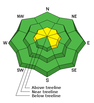
bottom line At and above treeline, in mid and upper elevation terrain, the avalanche danger is MODERATE. Human triggered avalanches are POSSIBLE, especially on steep, wind drifted slopes, and particularly on slopes facing the north half of the compass. Low elevation terrain, most south facing slopes, and terrain that held no snow prior to the Christmas Eve storm offer generally LOW avalanche danger.
|
 |
special announcement The information in this advisory expires 24 hours after the date and time posted, but will be updated by 7:00 AM on Saturday January 6th.
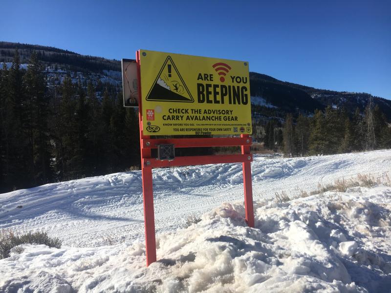
Big thanks to Salt Valley Snowmobile Club for sponsoring and maintaining this beacon checker at Soapstone. Not hard to miss and it's up and running in the main parking lot. |
 |
current conditions Skies are clear, winds light and northerly, and temperatures in the mid 20's. Riding and turning conditions are hit or miss. Recent winds have jacked a lot of the big open, upper elevation terrain, but soft snow is still found on mid elevation, wind protected slopes.
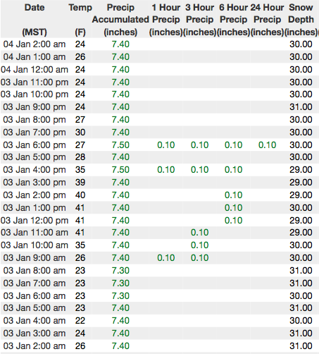
Above are 24 hour temperatures and snow depth from Trial Lake along with winds and temperatures from Windy Peak. More remote Uinta weather stations are found here Recent trip reports and findings can be seen here.
Trailheads are thin and boney, but with some elevation gain you'll find resonable riding conditions with fresh, clean air. |
 |
recent activity No new avalanche activity in five days. Click here to see last weeks recap. |
| type | aspect/elevation | characteristics |
|---|

|
|
LIKELIHOOD
 LIKELY
UNLIKELY
SIZE
 LARGE
SMALL
TREND
 INCREASING DANGER
SAME
DECREASING DANGER
|
|
description
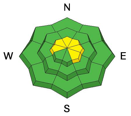
Our pesistent slab has relaxed somehwat and as a result, avalanche activity has subsided the past few days. Of course that's good news, but the Uinta's are a big place and I bet thre's still a steep, wind drifted slope or two that would come to life with a good thump.
Our problem child buried in the midpack is a persistent weakness and that's an issue because anything "persistent" in the snowpack takes a long time to heal.
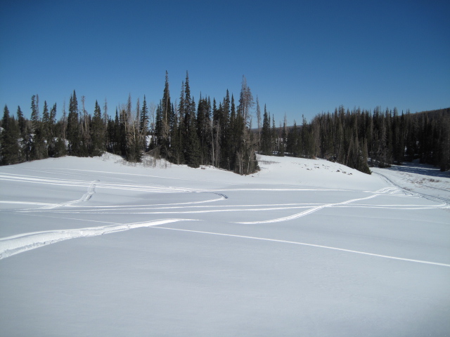
The good news is, there's plenty of good riding on low angle slopes and big open meadows like the one pictured above, where you can ride and you don't even have to deal with the persistent slab issue. |
| type | aspect/elevation | characteristics |
|---|

|
|
LIKELIHOOD
LIKELY
UNLIKELY
SIZE
LARGE
SMALL
TREND
INCREASING DANGER
SAME
DECREASING DANGER
|
|
description
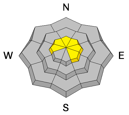
While most of our wind drifts have become tired and lifeless, you'll want to look for and avoid any fat, rounded piece of snow, especially if it sounds hollow like a drum. The snowpack is still relatively thin and the bummer with low tide conditions is, triggering even a small slide greatly increases your chances of slamming into a season ending rock or stump.
|
 |
weather
Skies will be mostly sunny with temperatures climbing into the low 40's and overnight lows in the 20's. Ridgetop winds remain light and northerly. A gradual warming trend is on tap through Friday. A weak storm slides through the region Saturday afternoon for a couple inches of snow. |
| general announcements The information in this advisory expires 24 hours after the date and time posted, but will be updated by 7:00 AM Saturday January 6, 2018. If you're getting out and about, please let me know what you're seeing especially if you see or trigger and avalanche. I can be reached at [email protected] or 801-231-2170 It's also a good time to set up one of our very popular avalanche awareness classes. Reach out to me and I'll make it happen. This information does not apply to developed ski areas or highways where avalanche control is normally done. This advisory is from the U.S.D.A. Forest Service, which is solely responsible for its content. This advisory describes general avalanche conditions and local variations always occur. |