25th Annual Black Diamond Fall Fundraising Party
Thursday, September 13; 6:00-10:00 PM; Black Diamond Parking Lot
25th Annual Black Diamond Fall Fundraising Party
Thursday, September 13; 6:00-10:00 PM; Black Diamond Parking Lot
| Advisory: Uintas Area Mountains | Issued by Craig Gordon for Wednesday - April 12, 2017 - 4:00am |
|---|

|
bottom line While making up for a small percentage of the terrain available to ride in today, at and above treeline in the wind zone, pockets of MODERATE avalanche danger exist. Human triggered avalanches are possible on steep, wind drifted, leeward slopes. In addition, the danger of human triggered wet avalanches increases to MODERATE during the heat of the day, especially on steep, sun-baked slopes at mid and lower elevations.
|
 |
special announcement This Sunday, April 16th will be the last of the regularly scheduled western Uinta Advisories |
 |
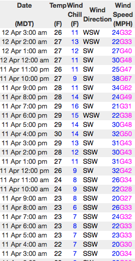
current conditions Skies cleared overnight and currently, temperatures hover in the upper 20's. Southwest winds increased late yesterday morning and have continued blowing in the 30's and 40's with a few higher gusts along the upper elevation ridgelines. Riding and turning conditions are hit or miss, but it's gonna be a beautiful day in the mountains and even a mediocre day of riding is better than an epic day cleaning out the garage. On a go anywhere base and with a little elevation gain, set your sights on north facing terrain and I think you'll be rewarded with shallow, cold snow. Above... 24 hour wind data from Lofty Lake Peak (11,186') and current snow depths at Trial Lake (9,992') Real time temperatures, snowfall and wind for the western Uintas are found here. Snowpack observations and trip reports are found here. |
 |
recent activity No significant avalanches to report from yesterday. A full list of Uinta avalanche activity is found here. |
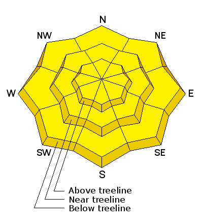
| type | aspect/elevation | characteristics |
|---|

|
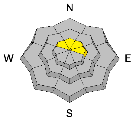
|
LIKELIHOOD
 LIKELY
UNLIKELY
SIZE
 LARGE
SMALL
TREND
 INCREASING DANGER
SAME
DECREASING DANGER
|
|
description
I think most of our wind drift issues have probably settled out, but the Uintas are a big place and wind always seem to find just enough snow to grab and form fresh drifts sensitive to our additional weight. That said... I bet there's still a rogue drift or two lurking on a steep gully wall or chute, or perhaps on the leeward side of an upper elevation ridgeline. In any case, today you'll want to continue looking for and avoiding any fat, rounded piece of snow, particularly if it feels or sounds hollow like a drum. Also remember... avalanche conditions can change very rapidly this time of year, especially with the strong springtime sun high in the sky. So, if you're hopping from one drainage to another take a moment or two and reassess the conditions before dropping in. And finally, cornices are epically huge and should be avoided. |
| type | aspect/elevation | characteristics |
|---|

|
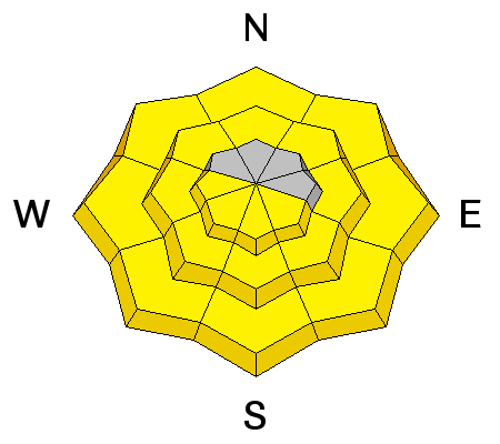
|
LIKELIHOOD
LIKELY
UNLIKELY
SIZE
LARGE
SMALL
TREND
 INCREASING DANGER
SAME
DECREASING DANGER
|
|
description
As the day heats up you'll want to get off and out from under steep, sun exposed slopes. Also consider your exit strategy and think about avoiding terrain traps like gullies and road cuts where even a shallow avalanche can stack up deep piles of tree snapping debris. |
 |
weather Expect mostly sunny skies with temperatures climbing into the low 50's. Southwest winds become strong, blowing in the 40's and 50's along the high peaks as a warm southerly flow develops today and becomes stronger on Thursday, ahead of an approaching cold front. The front crosses the region late Thursday evening with strong gusty winds and a chance of snow. A cool westerly flow will be over the area Friday with a few snow showers. The flow becomes southwesterly again Saturday through Sunday and warms back up. |
| general announcements Remember your information can save lives. If you see anything we should know about, please participate in the creation of our own community avalanche advisory by submitting snow and avalanche conditions. You can call me directly at 801-231-2170, email [email protected] The information in this advisory is from the US Forest Service which is solely responsible for its content. This advisory describes general avalanche conditions and local variations always occur. The information in this advisory expires 24 hours after the date and time posted, but will be updated by 7:00 AM on Thursday April 13th. |