25th Annual Black Diamond Fall Fundraising Party
Thursday, September 13; 6:00-10:00 PM; Black Diamond Parking Lot
25th Annual Black Diamond Fall Fundraising Party
Thursday, September 13; 6:00-10:00 PM; Black Diamond Parking Lot
| Advisory: Uintas Area Mountains | Issued by Craig Gordon for Monday - April 10, 2017 - 3:47am |
|---|

|
bottom line In the wind zone, at and above treeline, the avalanche danger is MODERATE. Human triggered avalanches are possible on steep, wind drifted, leeward slopes. In addition, the danger of wet avalanches increases to MODERATE during the heat of the day, especially on steep, sun-baked slopes at mid and lower elevations.
|
 |
special announcement This Sunday, April 16th will be the last of the regularly scheduled western Uinta Advisories |
 |
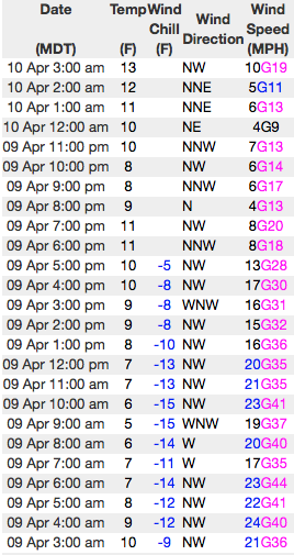
current conditions In the wake of Saturday's storm, skies cleared late yesterday and temperatures crashed into the teens and single digits overnight. Currently, winds are light and northerly, blowing just 10-20 mph even along the highest peaks. The weekend storm was very North Slope-centric with nearly a foot of snow stacking up around Chalk Creek. The further south you travel past Trial Lake new snow depths drastically diminish, with Daniels only picking up a few inches. The sun will have its way, so get out and get after it early today.
Above... 24 hour wind data from Lofty Lake Peak (11,186') and current snow depths at Trial Lake (9,992') Real time temperatures, snowfall and wind for the western Uintas are found here. Snowpack observations and trip reports are found here. |
 |
recent activity Pockety, shallow soft slabs breaking up to a foot deep were reported on steep, leeward slopes yesterday. A full list of Uinta avalanche activity is found here. |
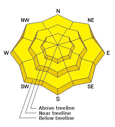
| type | aspect/elevation | characteristics |
|---|

|
|
LIKELIHOOD
 LIKELY
UNLIKELY
SIZE
 LARGE
SMALL
TREND
 INCREASING DANGER
SAME
DECREASING DANGER
|
|
description
Yesterday's avalanche problems were pretty straight-forward and confined to upper elevation, leeward slopes in the wind zone. While I think most of our wind drift issues have probably settled out, I bet there's still a rogue drift or two lurking on a steep gully wall or chute, or perhaps on the leeward side of an upper elevation ridgeline. In any case, today you'll want to continue looking for and avoiding any fat, rounded piece of snow, particularly if it feels or sounds hollow like a drum. Also remember... avalanche conditions can change very rapidly this time of year, especially if the sun pokes out for any length of time. So, if you're hopping from one drainage to another take a moment or two and reassess the conditions before dropping in. And finally, cornices are epically huge and should be avoided. |
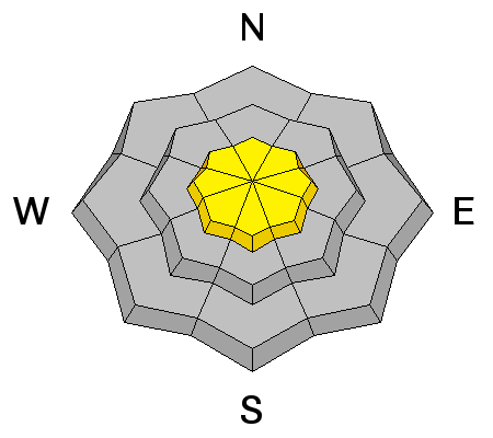
| type | aspect/elevation | characteristics |
|---|

|
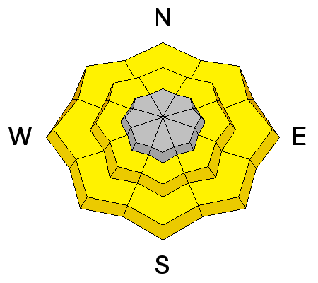
|
LIKELIHOOD
LIKELY
UNLIKELY
SIZE
 LARGE
SMALL
TREND
 INCREASING DANGER
SAME
DECREASING DANGER
|
|
description
The cold, storm snow will get a taste of strong, springtime sun and is gonna take on heat today. What this means is, as the day heats up you'll want to get off and out from under steep, sun exposed slopes. |
 |
weather It'll be a stunning day in the mountains with clear skies and temperatures rising into the upper 30's. Winds switch to the southwest late in the ay and clouds increase. A weak system brings considerable cloudiness Tuesday into Tuesday evening with a slight chance of afternoon and evening showers. A warm southerly flow develops Wednesday. |
| general announcements Remember your information can save lives. If you see anything we should know about, please participate in the creation of our own community avalanche advisory by submitting snow and avalanche conditions. You can call me directly at 801-231-2170, email [email protected] The information in this advisory is from the US Forest Service which is solely responsible for its content. This advisory describes general avalanche conditions and local variations always occur. The information in this advisory expires 24 hours after the date and time posted, but will be updated by 7:00 AM on Tuesday April 11th. |