25th Annual Black Diamond Fall Fundraising Party
Thursday, September 13; 6:00-10:00 PM; Black Diamond Parking Lot
25th Annual Black Diamond Fall Fundraising Party
Thursday, September 13; 6:00-10:00 PM; Black Diamond Parking Lot
| Advisory: Uintas Area Mountains | Issued by Craig Gordon for Saturday - April 8, 2017 - 4:24am |
|---|

|
bottom line In general the avalanche danger is LOW this morning. As the storm starts taking shape, the avalanche danger rises to MODERATE and human triggered avalanches become possible on steep, wind drifted terrain at and above treeline, especially on slopes facing the north half of the compass.
|
 |
special announcement Next Sunday, April 16th will be the last of the regularly scheduled western Uinta Advisories |
 |
current conditions A storm is churning to the west, signaling a change in the weather pattern and it's slated to arrive later today. In the meantime, clouds are streaming into the region, southwest winds are cranking in the 60's and 70's along the high ridges, and temperatures hover near freezing. Riding and turning conditions are a mixed bag and a bit underwhelming, but there's a good shot of snow slated for later today. So it might be a good morning to hold off, get some projects off your plate, and get after it later in the day as the storm evolves.
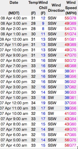
Well, we have two flavors of wind today.... south-southwest or strictly southwest. Either way you cut it winds are cranking. Above, 24 hour wind data from Windy Peak (10,166') and Lofty Lake Peak (11,186') Real time temperatures, snowfall and wind for the western Uintas are found here. Snowpack observations and trip reports are found here. |
 |
recent activity No significant avalanches to report from yesterday. A full list of Uinta avalanche activity is found here. |
| type | aspect/elevation | characteristics |
|---|

|

|
LIKELIHOOD
 LIKELY
UNLIKELY
SIZE
 LARGE
SMALL
TREND
 INCREASING DANGER
SAME
DECREASING DANGER
|
|
description
With a change in the weather and new snow on tap we'll need to shift back to winter mode and start thinking about new snow avalanche problems and that of course, involves fresh deposits of wind drifted snow. I don't think the avalanche danger starts to increase until much later today, but none-the-less, be on the lookout for rapidly changing conditions, especially if the storm arrives early or we get more snow than expected. |
| type | aspect/elevation | characteristics |
|---|

|

|
LIKELIHOOD
 LIKELY
UNLIKELY
SIZE
 LARGE
SMALL
TREND
 INCREASING DANGER
SAME
DECREASING DANGER
|
|
description
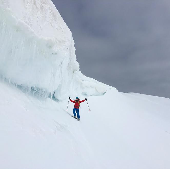
Paul Diegel, Executive Director of the Friends of the UAC was near Bald Mountain and said this about our corni. "Cornices remain massive and hostile-looking, in some cases on both sides of ridgelines. These are going to fail spectacularly and it would be bad to be within striking range when that happens." His trip report is found here. (Weston D images) |
 |
weather Expect cloudy skies with temperatures climbing into the low 40's. Rain and snow showers continue at times throughout the day with high snow levels. Southwest winds ramp up even more, nuking into the 70's and 80's prior to the cold front arriving late in the day, bringing heavy snow, along with a chance of thunderstorms. A cold, moist northwest flow develops overnight and I think we'll see a foot of snow by Sunday morning.
|
| general announcements Remember your information can save lives. If you see anything we should know about, please participate in the creation of our own community avalanche advisory by submitting snow and avalanche conditions. You can call me directly at 801-231-2170, email [email protected] The information in this advisory is from the US Forest Service which is solely responsible for its content. This advisory describes general avalanche conditions and local variations always occur. The information in this advisory expires 24 hours after the date and time posted, but will be updated by 7:00 AM on Sunday April 9th. |