25th Annual Black Diamond Fall Fundraising Party
Thursday, September 13; 6:00-10:00 PM; Black Diamond Parking Lot
25th Annual Black Diamond Fall Fundraising Party
Thursday, September 13; 6:00-10:00 PM; Black Diamond Parking Lot
| Advisory: Uintas Area Mountains | Issued by Craig Gordon for Friday - April 7, 2017 - 4:14am |
|---|

|
bottom line In general the avalanche danger is LOW today, though small, yet predictable wet sluffs can be triggered on steep slopes during the heat of the day.
|
 |
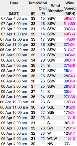
current conditions Under mostly cloudy skies, temperatures are in the mid 30's and low 40's. The bigger news are the southwest winds... and they're nuking in the 60's and 70's along the high peaks. Riding and turning conditions are a mixed bag, but with a good shot of snow slated for Saturday it might be a good day to get some projects off your plate and get after it tomorrow.
"Clowns to the left of me ... jokers to the right" ... either way you cut it, winds are cranking. Above, 24 hour wind data from Windy Peak (10,166') and Lofty Lake Peak (11,186') Real time temperatures, snowfall and wind for the western Uintas are found here. Snowpack observations and trip reports are found here. |
 |
recent activity No significant avalanches to report from yesterday. A full list of Uinta avalanche activity is found here. |
| type | aspect/elevation | characteristics |
|---|

|
|
LIKELIHOOD
 LIKELY
UNLIKELY
SIZE
 LARGE
SMALL
TREND
 INCREASING DANGER
SAME
DECREASING DANGER
|
|
description
After a couple nights of a deep, solid refreeze, I think our snowpack can handle a little heat and any avalanches triggered today will be shallow and predictable. In addition, cloud cover and storng winds should keep the snow surface cool. However, if it warms up quicker than expected, the sun pokes out for any significant length of time, or you find yourself sinking into wet, bottomless mush, you'll want to get off of and out from under any steep, sun-exposed slope. Also, think about your exit strategy and avoid terran traps like gullies and road cuts where evn a small slide can stack up a surprisingly big pile of cement-like debris. |
| type | aspect/elevation | characteristics |
|---|

|
|
LIKELIHOOD
LIKELY
UNLIKELY
SIZE
 LARGE
SMALL
TREND
 INCREASING DANGER
SAME
DECREASING DANGER
|
|
description
Paul Diegel, Executive Director of the Friends of the UAC was near Bald Mountain and said this about our corni. "Cornices remain massive and hostile-looking, in some cases on both sides of ridgelines. These are going to fail spectacularly and it would be bad to be within striking range when that happens." His trip report is found here. (Weston D images) |
 |
weather Southwest winds are gonna crank into the 50's and 60's ahead of the approaching cold front slated for late tonight into Saturday,. High temperatures reach into the 40's with overnight lows in the 30's. Cold, unstable air slides into the region Saturday, giving us a good shot of snow. I think a foot of new snow by midday Sunday is a good bet. |
| general announcements Remember your information can save lives. If you see anything we should know about, please participate in the creation of our own community avalanche advisory by submitting snow and avalanche conditions. You can call me directly at 801-231-2170, email [email protected] The information in this advisory is from the US Forest Service which is solely responsible for its content. This advisory describes general avalanche conditions and local variations always occur. The information in this advisory expires 24 hours after the date and time posted, but will be updated by 7:00 AM on Saturday April 8th. |