25th Annual Black Diamond Fall Fundraising Party
Thursday, September 13; 6:00-10:00 PM; Black Diamond Parking Lot
25th Annual Black Diamond Fall Fundraising Party
Thursday, September 13; 6:00-10:00 PM; Black Diamond Parking Lot
| Advisory: Uintas Area Mountains | Issued by Craig Gordon for Sunday - April 2, 2017 - 4:55am |
|---|

|
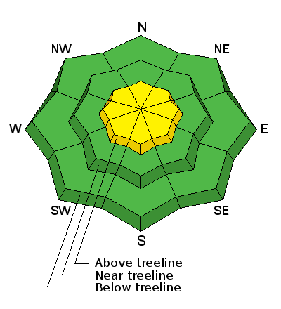
bottom line While not widespread and making up a small portion of the terrain available to ride in today, at and above treeline in the wind zone, you'll find pockets of MODERATE avalanche danger. Human triggered avalanches are POSSIBLE on steep, wind drifted slopes. Wind sheltered low and mid elevation terrain offers generally LOW avalanche danger.
|
 |
current conditions Skies cleared last night and we've got a good solid refreeze with temperatures in the 20's. West and northwest winds are blowing in the teens and 20's along the high ridges. Unfortunately, recent winds and a little greenhousing ruined a lot of good snow and quality riding conditions are sorta hit or miss. However, being the eternal optimist that I am... a fair day of riding is better than an epic day cleaning the garage, and I think there's patches of soft snow on upper elevation, wind sheltered slopes... getting there this morning might be a bit rugged.
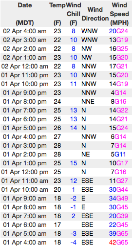
Above... 24 hour winds from Windy Peak (10,166') and a solid snowpack at the Trial Lake snotel site (9,992') Real time temperatures, snowfall and wind for the western Uintas are found here.
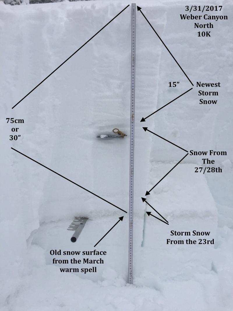
JG's pit profile clearly illustrates the series of storms from this week. More on his Friday travels in Weber Canyon are found here. Snowpack observations and trip reports are found here. |
 |
recent activity
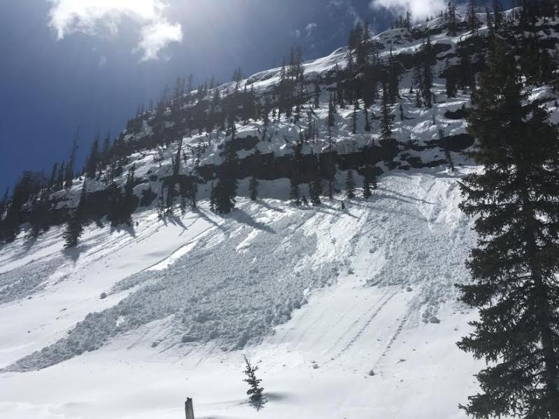
Dan Gardiner found this wet slide yesterday, cascading off a cliff band near the Mirror Lake Highway. (Gardiner image) A full list of Uinta avalanche activity is found here. |
| type | aspect/elevation | characteristics |
|---|

|
|
LIKELIHOOD
 LIKELY
UNLIKELY
SIZE
 LARGE
SMALL
TREND
 INCREASING DANGER
SAME
DECREASING DANGER
|
|
description
Thursday night's storm snow has been yanked all over the place. First, it got greenhoused and essentially shrink-wrapped with a few glimpses of sun Friday and then wind-jacked and welded in place early yesterday. While I think most of our terrain is good to go, the Uintas are a big place and I bet there's a wind drift or two lurking along the leeward side of an upper elevation ridge that'll still be sensitive to our additional weight. Today's slabs might be stout, stubborn, and not particularly rective 'til we get well out onto the slope. So, as always, look for and avoid any fat, rounded piece of snow, especially if it feels or sounds hollow like a drum. |
| type | aspect/elevation | characteristics |
|---|

|
|
LIKELIHOOD
 LIKELY
UNLIKELY
SIZE
 LARGE
SMALL
TREND
INCREASING DANGER
SAME
DECREASING DANGER
|
|
description
While today's corni might not be overly sensitive, these boxcar monsters are completely unpredictable and should definitely be avoided. |
 |
weather Clouds increase throughout the day and a cold front swings through the area later this afternoon bringing a couple inches of snow overnight. High temperatures reach into the mid 30's and west-northwest winds blow in the upper 20's along the high ridges. Snow showers continue on Monday with a midweek break slated before another storm slides into the region towards the end of the week. |
| general announcements Remember your information can save lives. If you see anything we should know about, please participate in the creation of our own community avalanche advisory by submitting snow and avalanche conditions. You can call me directly at 801-231-2170, email [email protected] The information in this advisory is from the US Forest Service which is solely responsible for its content. This advisory describes general avalanche conditions and local variations always occur. The information in this advisory expires 24 hours after the date and time posted, but will be updated by 7:00 AM on Monday April 3rd. |