25th Annual Black Diamond Fall Fundraising Party
Thursday, September 13; 6:00-10:00 PM; Black Diamond Parking Lot
25th Annual Black Diamond Fall Fundraising Party
Thursday, September 13; 6:00-10:00 PM; Black Diamond Parking Lot
| Advisory: Uintas Area Mountains | Issued by Craig Gordon for Saturday - April 1, 2017 - 4:18am |
|---|

|
bottom line At and above treeline in the wind zone, you'll find MODERATE avalanche danger. Human triggered avalanches are POSSIBLE on steep, wind drifted slopes, especially those with a westerly component to their aspect. Wind sheltered low and mid elevation terrain offers generally LOW avalanche danger.
|
 |
current conditions As yesterday's storm exited the state, it set up shop in the four corners late in the day. As a result, skies cleared, temperatures dove into the teens, and easterly winds started ramping up around dinnertime. Unfortunately, they've continued blowing in the 40's and 50's all night. In addition, our storm snow took on heat and nearly every aspect at mid and low elevations got greenhoused. So we've got two flavors of backcountry snow today... either crusty, which will soften as they day progresses, or wind-jacked, which is gonna need some new snow before it turns around.
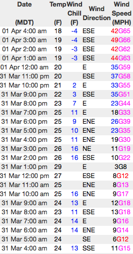
Above... 24 hour winds from Windy Peak (10,166') and Lofty Lake Peak (11,186') Real time temperatures, snowfall and wind for the western Uintas are found here.
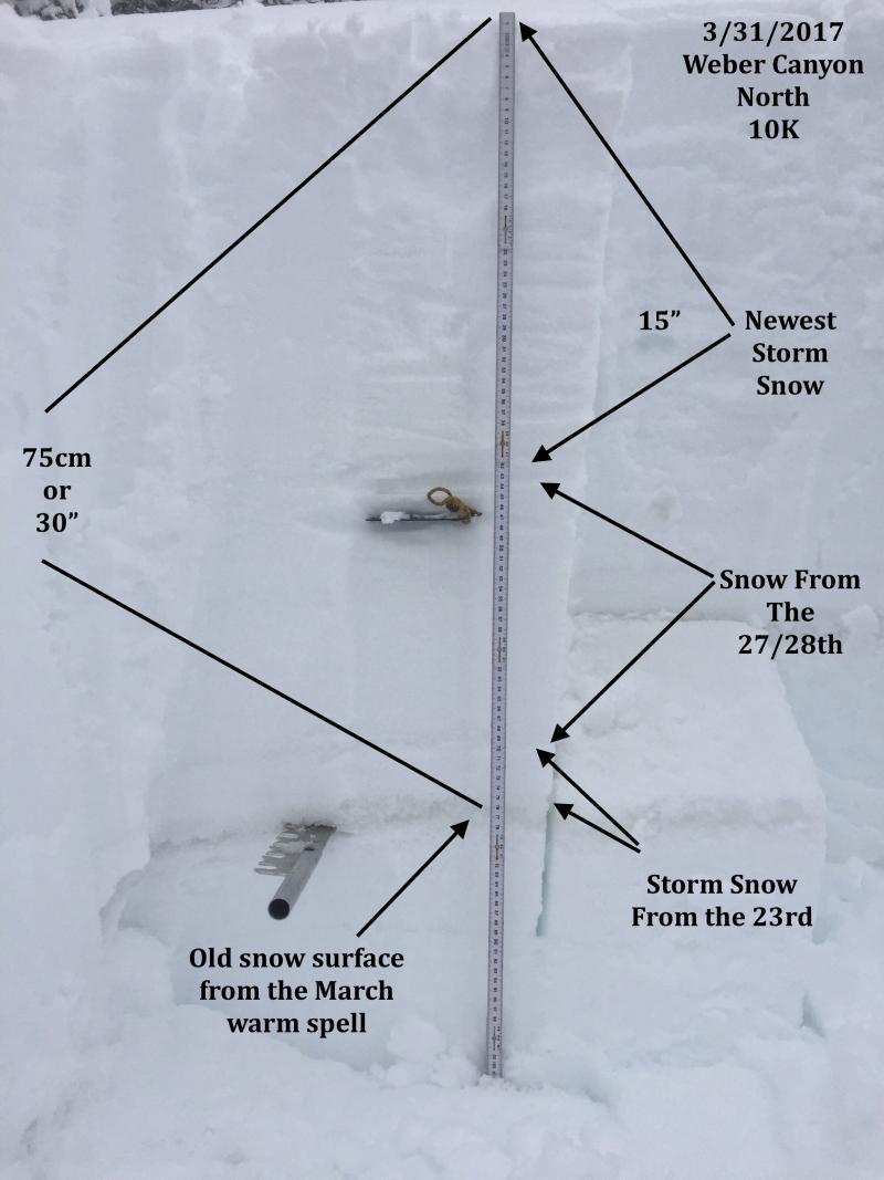
JG's pit profile clearly illustrates the series of storms from this week. More on his travels in Weber canyon are found here. Snowpack observations and trip reports are found here. |
 |
recent activity A few shallow wind slabs and some damp "push-alanches" were reported on steep slopes throughout the range, otherwise pretty quiet on the eastern front. A full list of Uinta avalanche activity is found here. |
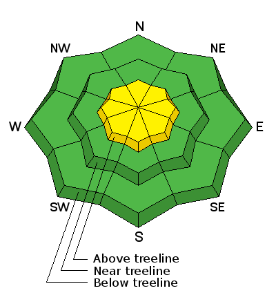
| type | aspect/elevation | characteristics |
|---|

|
|
LIKELIHOOD
 LIKELY
UNLIKELY
SIZE
 LARGE
SMALL
TREND
 INCREASING DANGER
SAME
DECREASING DANGER
|
|
description
While much of our terrain got shrink-wrapped yesterday, upper elevation slopes remained cool and still have enough loose snow to blow around. Add in some strong winds blowing from an easterly direction and that means fresh slabs formed on slopes with a westerly component to their aspect... that's unusual for us. While I think this problem is mostly confined to upper elevation slopes in the wind zone, there might be a drift or two lurking around a mid elevation terrain feature like a chute or gully wall. In either case, take a moment and re-evaluate your terrain choices especially if your jumping from drainiage to drainage or getting into steep, committing terrain. Today's slabs might be stout and stubborn and not particularly rective 'til we get well out onto the slope. So, as always, look for and avoid any fat, rounded piece of snow, especially if it feels or sounds hollow like a drum. |
| type | aspect/elevation | characteristics |
|---|

|
|
LIKELIHOOD
LIKELY
UNLIKELY
SIZE
 LARGE
SMALL
TREND
INCREASING DANGER
SAME
DECREASING DANGER
|
|
description
While today's corni might not be overly sensitive, these boxcar monsters are completely unpredictable and should definitely be avoided. |
 |
weather Look for partly cloudy skies with winds decreasing by late morning. Temperatures rise into the upper 30's and dip into the mid 20's overnight. Increasing clouds Sunday with a weak system sliding through the region late in the day. Perhaps a better shot of snow for Monday/Tuesday. |
| general announcements Remember your information can save lives. If you see anything we should know about, please participate in the creation of our own community avalanche advisory by submitting snow and avalanche conditions. You can call me directly at 801-231-2170, email [email protected] The information in this advisory is from the US Forest Service which is solely responsible for its content. This advisory describes general avalanche conditions and local variations always occur. The information in this advisory expires 24 hours after the date and time posted, but will be updated by 7:00 AM on Sunday April 2nd. |