25th Annual Black Diamond Fall Fundraising Party
Thursday, September 13; 6:00-10:00 PM; Black Diamond Parking Lot
25th Annual Black Diamond Fall Fundraising Party
Thursday, September 13; 6:00-10:00 PM; Black Diamond Parking Lot
| Advisory: Uintas Area Mountains | Issued by Craig Gordon for Wednesday - March 29, 2017 - 3:38am |
|---|

|
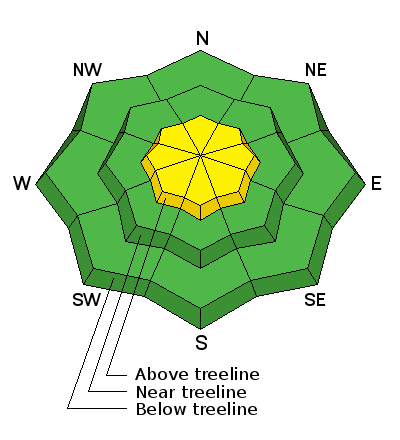
bottom line At and above treeline in the wind zone, a MODERATE avalanche danger exists and human triggered avalanches are POSSIBLE on steep slopes with recent deposits of wind drifted snow. Wind sheltered low and mid elevation terrain offers generally LOW avalanche danger.
|
 |
current conditions A stunning day is on tap for the eastern front! Skies are clear and temperatures in the teens. Northerly winds started relaxing late last night and currently blow 10-20 mph along the high ridges. Riding and turning conditions are quite good, though the recent bout of northeasterly winds had their way with our big open bowls. However, lose a little elevation, tuck into wind sheltered terrain and on a go-anywhere base, you'll be rewarded with amazing spring riding conditions.
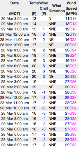
Above... 24 hour winds from Lofty Lake Peak (11,186') and the Trail Lake snotel site (9,992') Real time temperatures, snowfall and wind for the western Uintas are found here. Snowpack observations and trip reports are found here. |
 |
recent activity
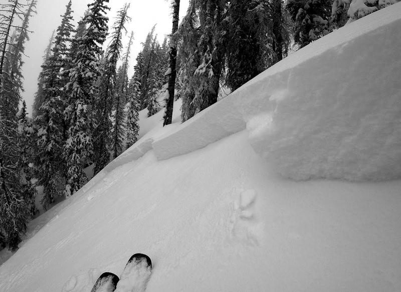
A rider triggered this wind drift yesterday on a steep, upper elevation, north facing, cross-loaded gully in Weber Canyon. Breaking about 2' deep and not particularly connected due to terrain features, I think there's a few pockets like this one still lurking in the wind zone today. (Provo image) A full list of Uinta avalanche activity is found here. |
| type | aspect/elevation | characteristics |
|---|

|

|
LIKELIHOOD
 LIKELY
UNLIKELY
SIZE
 LARGE
SMALL
TREND
 INCREASING DANGER
SAME
DECREASING DANGER
|
|
description
Winds were all over the place as Monday's storm developed and dense drifts formed in some unusual, terrain driven locations, such as gullies, chutes, and around sub-ridges. The good news is... the problem isn't widespread and a few glimpses of sun yesterday along with some greenhousing, shrink-wrapped most of our low and mid elevation terrain, essentially locking it up. For today, the focus shifts to steep, upper elevation, wind drifted terrain where I think you'll still be able to find a slab or two sensitive to our additional weight. While not particulalry deep or wide, once triggered, today's slabs will still pack enough punch to take you for an unexpected ride and could easily ruin your day, especially if you're charging hard in steep, commiting terrain. Ready for more good news... I thought you were. We've got a solid, well-behaved snowpack, today's avalanche hazard is straight-forward, and this is an easy avalanche problem to deal with. Lose a little elevation, you lose the problem, and you get a great day of riding in to boot... not a bad way roll. |
| type | aspect/elevation | characteristics |
|---|

|

|
LIKELIHOOD
 LIKELY
UNLIKELY
SIZE
 LARGE
SMALL
TREND
 INCREASING DANGER
SAME
DECREASING DANGER
|
|
description
While today's corni might not be overly sensitive, these boxcar monsters are completely unpredictable and should definitely be avoided. |
 |
weather High pressure brings a beautiful day to the region with sunny skies and temperatures climbing into the upper 30's. Winds shift to the northwest and blow in the 20's and low 30's near the high peaks. Clouds increase tonight ahead of a storm system slated to impact the region tomorrow afternoon through Friday. Another foot of snow is possible by late Friday.
|
| general announcements Remember your information can save lives. If you see anything we should know about, please participate in the creation of our own community avalanche advisory by submitting snow and avalanche conditions. You can call me directly at 801-231-2170, email [email protected] The information in this advisory is from the US Forest Service which is solely responsible for its content. This advisory describes general avalanche conditions and local variations always occur. The information in this advisory expires 24 hours after the date and time posted, but will be updated by 7:00 AM on Thursday March 30th. |