25th Annual Black Diamond Fall Fundraising Party
Thursday, September 13; 6:00-10:00 PM; Black Diamond Parking Lot
25th Annual Black Diamond Fall Fundraising Party
Thursday, September 13; 6:00-10:00 PM; Black Diamond Parking Lot
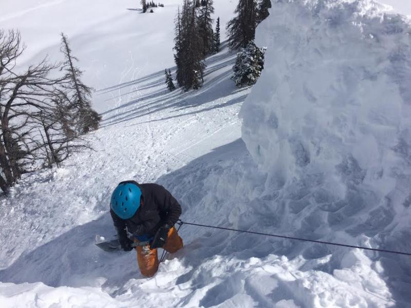
| Advisory: Uintas Area Mountains | Issued by Craig Gordon for Friday - March 10, 2017 - 3:27am |
|---|


|
bottom line This morning the avalanche danger is generally LOW. By afternoon, the danger for wet slides and sluffs increases to MODERATE and human triggered avalanches are POSSIBLE on all steep, sun-exposed, slopes.
|
 |
current conditions High clouds drifted in and out of the region overnight and temperatures remained somewhat mild, currently registering in the upper 20's and mid 30's. West and southwest winds are blowing 20-25 mph along the high ridges. An early corn harvest awaits on low and mid elevation south facing terrain. On the north half of the compass, you'll still find cold creamy snow on wind sheltered, upper elevation slopes.
Real time wind, snow, and temperatures for the Uinta's are found here
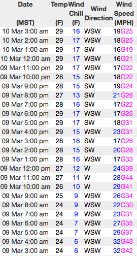
Don't try this at home.... our main man Ted Scroggin was in Humpy Creek Thursday and found great riding, along with predictable avalanche conditions. This guy knows the Uinta's like no other. More on his thoughts, travels, and insight can be found here. Snowpack observations and trip reports are found here. |
 |
recent activity
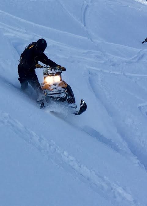
Thick as a brick... Ted found these massive chunks of corni that broke off naturally, triggering a small soft slab No new avalanche activity to report from yesterday. A full list of Uinta avalanche activity is found here. |
| type | aspect/elevation | characteristics |
|---|

|
|
LIKELIHOOD
 LIKELY
UNLIKELY
SIZE
 LARGE
SMALL
TREND
 INCREASING DANGER
SAME
DECREASING DANGER
|
|
description
The sun is high in the sky and it's penetrating all aspects at mid and lower elevations. If you're feeling like an ant under a magnifying glass, so is the snow. This is the time of year when you wanna think about your late in the day, exit strategy. As the snow turns damp and manky, you'll need to get off of and out from under steep, sunny slopes and avoid terrain traps like gullies and road cuts where tree snapping, cement-like debris can stack up very deeply. |
| type | aspect/elevation | characteristics |
|---|

|
|
LIKELIHOOD
 LIKELY
UNLIKELY
SIZE
 LARGE
SMALL
TREND
INCREASING DANGER
SAME
DECREASING DANGER
|
|
description
Corni... they come in all shapes and sizes and some are larger than others. In either case, these unpredictable pieces of snow are breaking further back than you might expect and you definitely don't want to be on the receiving end of one of these boxcar-like monsters.
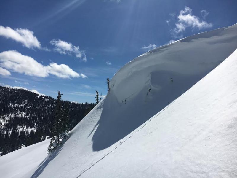
Pictured above, the crew in Upper Weber Canyon gettin' er done, as they safely and methodically.... swing by the Morrison Hotel, grab an LA Woman, and Break on Through to the Other Side. |
 |
weather We start off with mostly sunny skies, light winds, and temperatures climbing into the upper 40's. A weak cold slides through the region tonight, bringing a chance of some light snowfall. Drier and more stable conditions return for Saturday. Another weak system brings clouds, stronger winds, and cooler temperatures Saturday night into Sunday. |
| general announcements Remember your information can save lives. If you see anything we should know about, please participate in the creation of our own community avalanche advisory by submitting snow and avalanche conditions. You can call me directly at 801-231-2170, email [email protected] The information in this advisory is from the US Forest Service which is solely responsible for its content. This advisory describes general avalanche conditions and local variations always occur. The information in this advisory expires 24 hours after the date and time posted, but will be updated by 7:00 AM on Saturday March 11th. |