25th Annual Black Diamond Fall Fundraising Party
Thursday, September 13; 6:00-10:00 PM; Black Diamond Parking Lot
25th Annual Black Diamond Fall Fundraising Party
Thursday, September 13; 6:00-10:00 PM; Black Diamond Parking Lot
| Advisory: Uintas Area Mountains | Issued by Craig Gordon for Tuesday - March 7, 2017 - 3:25am |
|---|


|
bottom line In the wind zone at and above treeline, you'll find CONSIDERABLE avalanche danger. Human triggered avalanches are LIKELY on steep, upper elevation wind drifted, leeward slopes facing the north half of the compass, especially slopes with an easterly component to their aspect. Mid elevation terrain offers MODERATE avalanche danger and human triggered avalanches are possible on steep slopes with recent deposits of wind drifted snow. Looking for LOW avalanche danger? Stick with wind sheltered low and mid elevation terrain with no steep slopes above or adjacent to where you're riding.
|
 |
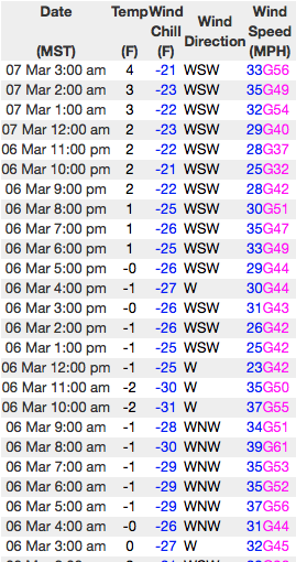
current conditions Yesterday's trailing system stacked up an additional 2" or 3" of light density snow. This morning, scattered snow showers linger over the area under mostly cloudy skies. Winds switched to the west and southwest around lunchtime and have been blowing 30-50 mph along the high ridges. Temperatures are in the teens and single digits. Recent winds have worked our big open bowls, but lose a little elevation, steer towards wind sheltered, mid elevation terrain and you'll be rewarded with cold, creamy snow.
Real time wind, snow, and temperatures for the Uinta's are found here Snowpack observations and trip reports are found here. |
 |
recent activity Breaking a foot deep and running long distances, fresh drifts were sensitive to the additional weight of riders yesterday. A full list of Uinta avalanche activity is found here. |
| type | aspect/elevation | characteristics |
|---|

|

|
LIKELIHOOD
 LIKELY
UNLIKELY
SIZE
 LARGE
SMALL
TREND
 INCREASING DANGER
SAME
DECREASING DANGER
|
|
description
Since Saturday, winds have been all over the place, loading slopes in unusual locations, forming both hard and soft wind slabs. There's no shortage of light density snow to blow around and drifts, sensitive to our additional weight are today's main avalanche concern. It's a pretty straight-forward avalanche dragon to contend with, so the key to a successful day of riding is avoiding terrain where you can trigger an avalanche. Mid and upper elevation, cross-loaded chutes, gullies, or bowl features are likely suspects. Any avalanche triggered in terrain with these characteristics may be a little bigger than you bargained for. Today you'll want to look for and steer clear of both soft and hard, fat rounded pieces of snow, particularly if they feel or sound hollow like a drum. The good news is... this is an easy avalanche problem to avoid. Simply lose some elevation, get into wind sheltered terrain, and you begin to lose the problem. |
| type | aspect/elevation | characteristics |
|---|

|

|
LIKELIHOOD
 LIKELY
UNLIKELY
SIZE
LARGE
SMALL
TREND
INCREASING DANGER
SAME
DECREASING DANGER
|
|
description
Corni... they're ridiculous this year, stretch for miles along the ridges, and are breaking back further than you might expect. You definitely want to give these unpredictable boxcar monsters the respect they deserve. |
 |
weather A westerly flow sets up over the region through midweek, giving us overcast skies, on again/off again snow showers, and mild temperatures. Highs reach into the low 30's with overnight lows dipping into the 20's. Westerly winds will be a nuisance along the ridges, blowing 25-35 mph with gusts in the 50's near the high peaks. Significant warming takes place Wednesday and Thursday with the computer models still trying to find a solution to the storm track later in the week. |
| general announcements Remember your information can save lives. If you see anything we should know about, please participate in the creation of our own community avalanche advisory by submitting snow and avalanche conditions. You can call me directly at 801-231-2170, email [email protected] The information in this advisory is from the US Forest Service which is solely responsible for its content. This advisory describes general avalanche conditions and local variations always occur. The information in this advisory expires 24 hours after the date and time posted, but will be updated by 7:00 AM on Wednesday March 8th. |