25th Annual Black Diamond Fall Fundraising Party
Thursday, September 13; 6:00-10:00 PM; Black Diamond Parking Lot
25th Annual Black Diamond Fall Fundraising Party
Thursday, September 13; 6:00-10:00 PM; Black Diamond Parking Lot
| Advisory: Uintas Area Mountains | Issued by Craig Gordon for Wednesday - March 1, 2017 - 3:31am |
|---|


|
bottom line While not widespread and making up a small portion of the terrain available to ride in today, at and above treeline in the wind zone, you'll find pockets of CONSIDERABLE avalanche danger. Human triggered avalanches are LIKELY on all steep wind drifted slopes. A MODERATE avalanche danger is found in mid elevation terrain and human triggered avalanches are possible on steep slopes with recent deposits of wind drifted snow. Wind sheltered slopes in mid and lower elevations offer LOW avalanche danger.
|
 |
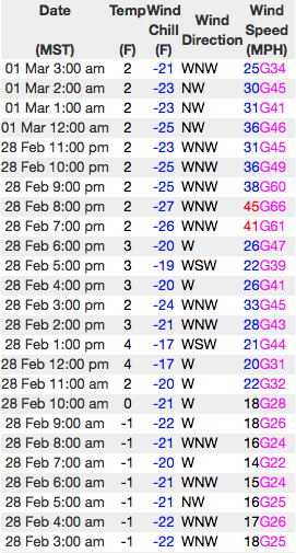
current conditions Skies are beginning to clear in the wake of yesterday's energetic storm which delivered 2"-4" of Utah, uber fluff. Since Monday night, the eastern front received just over 2' of snow. West-northwest winds bumped into the 50's and 60's around dinnertime last night, but have relaxed somewhat and currently blow in the 20's and 30's. With sunny skies, deep, cold pow, and a go anywhere base... today is the kind of riding and turning conditions that make our license plate famous. Real time wind, snow, and temperatures for the Uinta's are found here Snowpack observations and trip reports are found here. |
 |
recent activity
This naturally triggered wind slab on a SE aspect at 10,400' appeared to be initiated by a small cornice fall. Not overly huge, but at 2' deep x 150' wide, could definitely ruin your day. (C. Brown image) A full list of Uinta avalanche activity is found here. |
| type | aspect/elevation | characteristics |
|---|

|
|
LIKELIHOOD
 LIKELY
UNLIKELY
SIZE
 LARGE
SMALL
TREND
 INCREASING DANGER
SAME
DECREASING DANGER
|
|
description
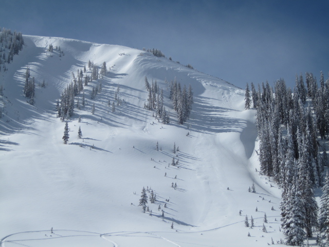
The recent avalanche activity from upper Weber Canyon reveals an insight into the snowpacks strength right now. The good news is... avalanches are pockety and failing within the storm snow. The less than good news is... just by shear virtue of the all the new snow we've received in the past few days, the snowpack needs a little break, time to adjust, and get comfortable in its own skin. With an additional load from last nights west and northwest winds, today's avalanches may break deeper and wider than you might expect. And any avalanche triggered today will involve a healthy dose of volume and can easily roll you. Of course, it doesn't mean you need to hide under the beds and can't ride. It does mean a successful day of riding involves avoiding steep, upper elevation, wind drifted slopes. Give the big bowls another day to settle out and get after it when the snowpack has had a little more time to heal.
Steep, leeward terrain... the image above illustrates the type of terrain you could trigger an avalanche in today. |
| type | aspect/elevation | characteristics |
|---|

|

|
LIKELIHOOD
 LIKELY
UNLIKELY
SIZE
LARGE
SMALL
TREND
 INCREASING DANGER
SAME
DECREASING DANGER
|
|
description
Corni... they're ridiculous this year, stretch for miles along the ridges, and are breaking back further than you might expect. You definitely want to give these unpredictable monsters the respect they deserve. |
 |
weather High pressure begins to build today and that gives us mostly sunny skies with temperatures warming into the low 20's. Northwest winds will be a nuisance for a few hours this morning, blowing into the 40's along the high ridges, but should relax as the day progresses. Warm and dry weather is on tap for the last half of the week. |
| general announcements Remember your information can save lives. If you see anything we should know about, please participate in the creation of our own community avalanche advisory by submitting snow and avalanche conditions. You can call me directly at 801-231-2170, email [email protected] The information in this advisory is from the US Forest Service which is solely responsible for its content. This advisory describes general avalanche conditions and local variations always occur. The information in this advisory expires 24 hours after the date and time posted, but will be updated by 7:00 AM on Thursday March 2nd. |