25th Annual Black Diamond Fall Fundraising Party
Thursday, September 13; 6:00-10:00 PM; Black Diamond Parking Lot
25th Annual Black Diamond Fall Fundraising Party
Thursday, September 13; 6:00-10:00 PM; Black Diamond Parking Lot
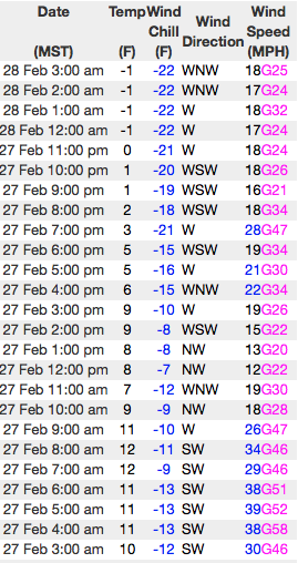
| Advisory: Uintas Area Mountains | Issued by Craig Gordon for Tuesday - February 28, 2017 - 3:25am |
|---|

|
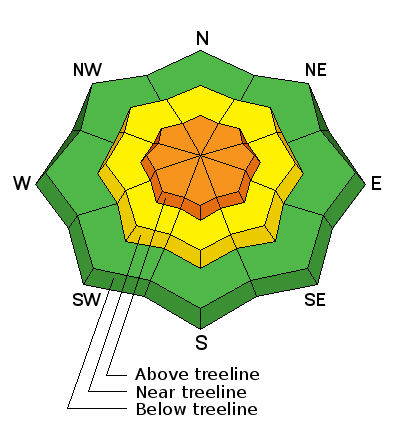
bottom line At and above treeline in the wind zone, you'll find a CONSIDERABLE avalanche danger. Human triggered avalanches are LIKELY on all steep wind drifted slopes. A MODERATE avalanche danger is found in mid elevation terrain and human triggered avalanches are possible on steep slopes with recent deposits of wind drifted snow. Wind sheltered slopes in mid and lower elevations offer LOW avalanche danger.
|
 |
current conditions Talk about the gift that keeps giving! Yesterday's storm came in fast and furious, quickly stacking up over a foot of snow. Trial Lake wins the overachiever award once again, registering 20" of new snow. Fortunately, winds have been pretty well behaved and currently clock in from the west and northwest in the teens and mid 20's. Under partly cloudy skies, temperatures are near zero. Epically deep riding and turning conditions await those who cash in their sick day vouchers today. Real time wind, snow, and temperatures for the Uinta's are found here
Ted was in Whitney Basin Sunday and found very good riding conditions and stable snow. Insights on his travels are found here. Snowpack observations and trip reports are found here. |
 |
recent activity Not many observations from yesterday, but the few people that got out reported tender soft slabs on steep, wind drifted slopes. A full list of Uinta avalanche activity is found here. |
| type | aspect/elevation | characteristics |
|---|

|
|
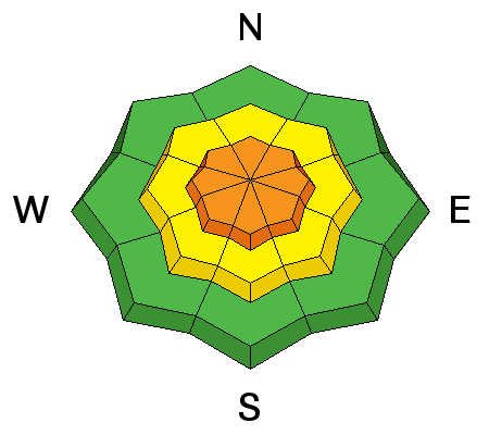
LIKELIHOOD
 LIKELY
UNLIKELY
SIZE
 LARGE
SMALL
TREND
 INCREASING DANGER
SAME
DECREASING DANGER
|
|
description
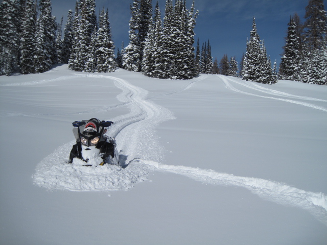
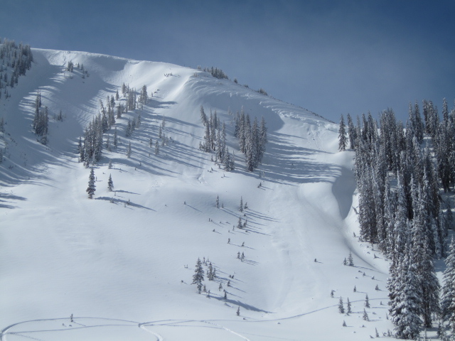
New wind drifts, old wind drifts, storm snow... you name it, we've got it and I'm going to lump them together. The good news is, pre-frontal winds quickly died down yesterday morning once the storm arrived and I think fresh drifts will offer a level of predictability... breaking at or below our skis, boards, or sleds. The less than good news is, just by shear virtue of the all the new snow we've received in the past 24 hours, the snowpack needs a little break, time to adjust, and get comfortable in its own skin. Any avalanche triggered today will involve a healthy dose of volume and can easily roll you. It doesn't mean you need to hide under the beds and can't ride. It does mean a successful day of riding involves avoiding steep, upper elevation, wind drifted slopes. Give the big bowls another day to settle out and get after it when the snowpack has had a little more time to heal.
Steep, leeward terrain... the image above illustrates the type of terrain you could trigger an avalanche in today. |
| type | aspect/elevation | characteristics |
|---|

|
|
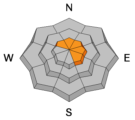
LIKELIHOOD
LIKELY
UNLIKELY
SIZE
LARGE
SMALL
TREND
INCREASING DANGER
SAME
DECREASING DANGER
|
|
description
Corni... they're ridiculous this year, stretch for miles along the ridges, and are breaking back further than you might expect. You definitely want to give these unpredictable monsters the respect they deserve. |
 |
weather One last piece of energy slides through the region today, ushering in a few light snow showers. Nothing like yesterday's storm and accumulations should be right around 4". High temperatures barely crack into the mid teens with overnight lows near zero. West and northwest winds blow in the 20's and 30's and could spike into the 50's late in the day. Warmer, drier weather sets up for the second half of the week. |
| general announcements Remember your information can save lives. If you see anything we should know about, please participate in the creation of our own community avalanche advisory by submitting snow and avalanche conditions. You can call me directly at 801-231-2170, email [email protected] The information in this advisory is from the US Forest Service which is solely responsible for its content. This advisory describes general avalanche conditions and local variations always occur. The information in this advisory expires 24 hours after the date and time posted, but will be updated by 7:00 AM on Wednesday March 1st. |