25th Annual Black Diamond Fall Fundraising Party
Thursday, September 13; 6:00-10:00 PM; Black Diamond Parking Lot
25th Annual Black Diamond Fall Fundraising Party
Thursday, September 13; 6:00-10:00 PM; Black Diamond Parking Lot
| Advisory: Uintas Area Mountains | Issued by Craig Gordon for Wednesday - February 22, 2017 - 3:27am |
|---|

|
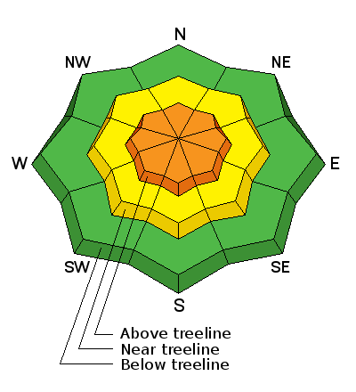
bottom line At and above treeline in the wind zone, you'll find CONSIDERABLE avalanche danger on steep wind drifted slopes. Both new and old wind drifts will react to our additional weight and human triggered avalanches are LIKELY. Once triggered, today's avalanches will break wider and deeper than you might expect. While less pronounced, a MODERATE avalanche danger is found in mid elevation terrain and human triggered avalanches are possible on steep slopes with recent deposits of wind drifted snow. Wind sheltered slopes at lower elevations offer LOW avalanche danger.
|
 |
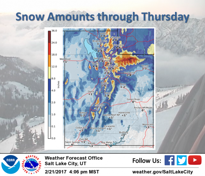
current conditions I'm driving a little blind this morning with no real-time snow data, but I'm thinking the range received close to 10" from last nights system. What I do know is... the cow-tipping southwest winds finally relaxed around 8:00 last night, switched to the west and northwest, and are blowing 15-25 mph along the ridges. Skies are mostly cloudy, light snow is falling and temperatures are in the teens. Last nights much needed reboot delivered a fresh coat of white paint, and mid elevation wind sheltered terrain is the place to be today.
Real time wind, snow, and temperatures for the Uinta's are found here
A dark and stormy day... winds raged along the ridges yesterday. Snowpack observations and trip reports are found here. |
 |
recent activity
A full list of Uinta avalanche activity is found here. |
| type | aspect/elevation | characteristics |
|---|

|

|
LIKELIHOOD
 LIKELY
UNLIKELY
SIZE
 LARGE
SMALL
TREND
 INCREASING DANGER
SAME
DECREASING DANGER
|
|
description
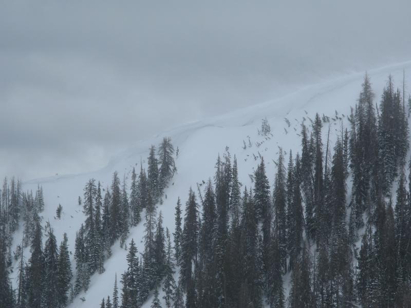
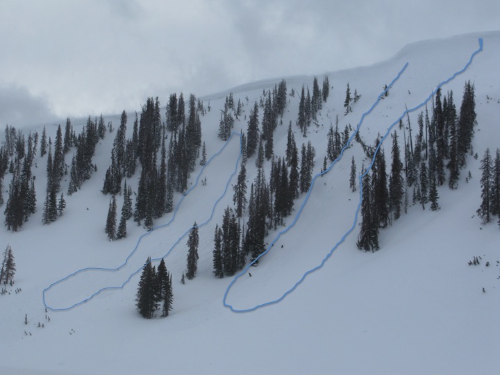
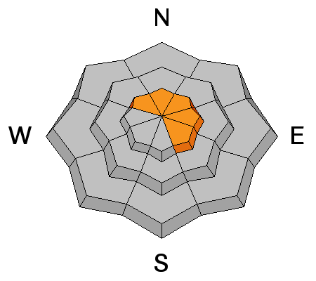
Yesterday's nuking southwest winds found what little snow there was available for transport and formed thick, dense slabs along the leeward side of upper elevation ridges. In addition, due to the strength of recent winds, drifts formed lower downslope than we usually see them. With new snow overnight and winds switching direction, both new and old slabs are going to be covered over with fresh snow, making them harder to detect. In any case, the best offense is a good defense. Today I'd look for and continue avoiding any fat, rounded piece of snow, especially if it feels or sounds hollow like a drum. Any avalanche triggered has the potential to pack a hefty punch... instantly ruining your day.
Wind from all directions has cross-loaded terrain features such as gullies and chutes like the terrain pictured above. |
| type | aspect/elevation | characteristics |
|---|

|
|
LIKELIHOOD
LIKELY
UNLIKELY
SIZE
LARGE
SMALL
TREND
INCREASING DANGER
SAME
DECREASING DANGER
|
|
description
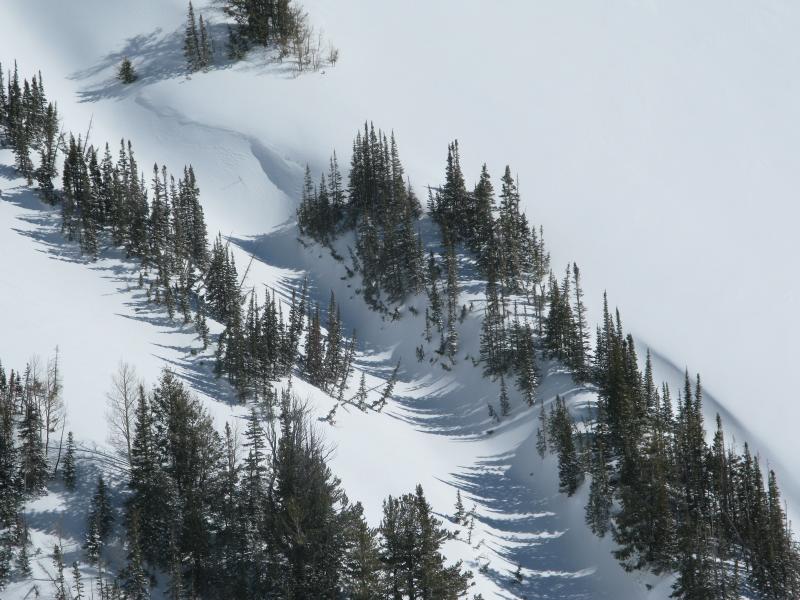
Recent winds coupled with dense snow are adding another layer to the already ginormous ridgeline corni. These unpredictable boxcar monsters are breaking further back than you'd think, and can easily take you for an unexpected, terrifying, elevator ride to the ground floor. |
 |
weather A good shot of snow continues this morning with an additional 4"-6" expected. Westerly winds blow in the 20's and 30's along the high ridges and temperatures top out in the low 30's. An increasingly cold northwest flow keeps snow showers going through Thursday night, especially on the North Slope.
|
| general announcements Remember your information can save lives. If you see anything we should know about, please participate in the creation of our own community avalanche advisory by submitting snow and avalanche conditions. You can call me directly at 801-231-2170, email [email protected] The information in this advisory is from the US Forest Service which is solely responsible for its content. This advisory describes general avalanche conditions and local variations always occur. The information in this advisory expires 24 hours after the date and time posted, but will be updated by 7:00 AM on Thursday February 23rd. |