25th Annual Black Diamond Fall Fundraising Party
Thursday, September 13; 6:00-10:00 PM; Black Diamond Parking Lot
25th Annual Black Diamond Fall Fundraising Party
Thursday, September 13; 6:00-10:00 PM; Black Diamond Parking Lot
| Advisory: Uintas Area Mountains | Issued by Craig Gordon for Monday - February 20, 2017 - 3:32am |
|---|

|
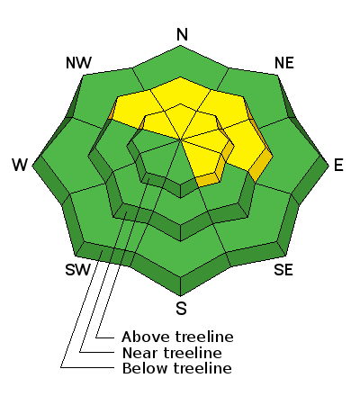
bottom line At and above treeline in the wind zone, you'll find MODERATE avalanche danger on steep leeward slopes facing the north half of the compass. Both new and old wind drifts will react to our additional weight and human triggered avalanches are possible. Once triggered, today's avalanches may pack more of a punch than you might expect. Wind sheltered terrain and most slopes facing the south half of the compass offer LOW avalanche danger.
|
 |
current conditions Skies are clear and temperatures in the teens and low 20's. Yesterday's storm favored the North Slope with 6" of dense snow... elsewhere storm totals register half that amount. Westerly winds bumped into the 50's and 60's late in the day, but relaxed somewhat overnight, switched to the southwest and are currently blowing 20-30 mph along the high ridges. On a go anywhere base and with a little effort, you'll find cold creamy snow on wind sheltered shady slopes. Real time wind, snow, and temperatures for the Uinta's are found here Snowpack observations and trip reports are found here. |
 |
recent activity Shallow soft slabs breaking up to a foot deep were reported on steep wind drifted slopes throughout the range. A full list of Uinta avalanche activity is found here. |
| type | aspect/elevation | characteristics |
|---|

|

|
LIKELIHOOD
 LIKELY
UNLIKELY
SIZE
 LARGE
SMALL
TREND
 INCREASING DANGER
SAME
DECREASING DANGER
|
|
description
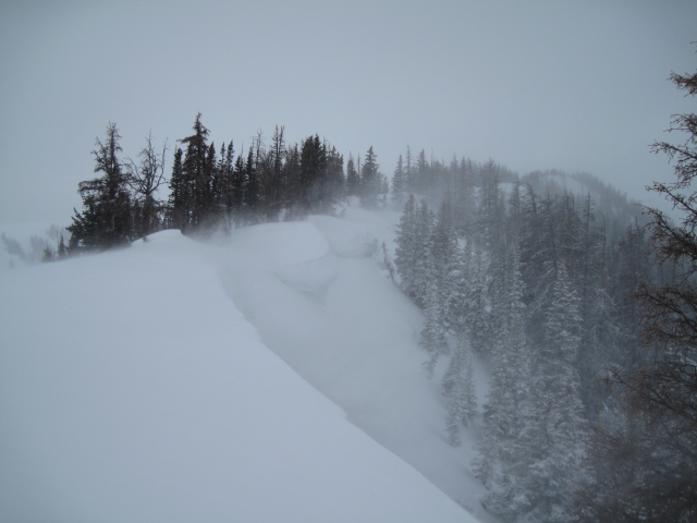
Yesterday's strong winds quickly whipped our dense storm snow into sensitive slabs. On steep, northerly slopes in the wind zone, small avalanches predictably breaking within the new snow were easily triggered with the additional weight of a person,. The good news is... I bet these instabilities settled out overnight and today's slabs won't be quite as widespread or touchy. None-the-less the Uinta's are a big range and I'm certain there's a lingering drift or two out there that's gonna react to our additional weight. Once triggered, today's slabs could easily boss you around. Fortunately, we can manage the avalanche dragon by avoiding the problem. Found mostly along the leeward side of upper elevation ridges and around terrain features like chutes, gullies, or sub-ridges, it's a good day to look for and avoid any fat, rounded piece of snow, especially if it sounds or feels hollow like a drum.
Recent winds coupled with dense snow are creating sensitive soft slabs on leeward slopes and adding another layer to the already ginormous ridgeline corni. |
 |
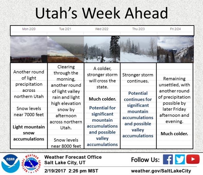
weather A mild southwest flow over the region, brings occasional snow showers and temperatures rising into the upper 30's. Southwest winds ramp up later today and should be blowing in the 60's and 70's around dinnertime. Scattered snow showers are on tap for Tuesday with a cold front crossing the area late in the day bringing a period of heavy snow. A cold, moist, west to northwest flow settles over the area Wednesday through about Friday. Storm totals could be several feet by the weekend.
|
| general announcements Remember your information can save lives. If you see anything we should know about, please participate in the creation of our own community avalanche advisory by submitting snow and avalanche conditions. You can call me directly at 801-231-2170, email [email protected] The information in this advisory is from the US Forest Service which is solely responsible for its content. This advisory describes general avalanche conditions and local variations always occur. The information in this advisory expires 24 hours after the date and time posted, but will be updated by 7:00 AM on Tuesday February 21st. |